by Dr J Floor Anthoni 2000
www.seafriends.org.nz/oceano/waves.htm
When the continental crust under water moves
suddenly, by an earth quake, it can cause a slow and very deep wave called
a tsunami. If the slump is large enough, a mega tsunami may result.
The ocean knows several kinds of special waves like seiches, bores and
internal waves. What kind of damage do these large waves cause under water
to the rocky shore, and how do they work? This chapter helps you understand
special waves.
Tsunamis are caused by deep earthquakes which disturb the water above
them, causing a wave front to radiate out at high speed. Tsunamis are unpredictable
and can cause considerable damage. Mega tsunamis
may occur when asteroids hit the ocean or when volcanoes erupt.
Internal waves are an interesting phenomenon that cannot be observed
from above. They propagate along layers caused by thermoclines, underlying
fresh water and the like. They can cause sizeable undersea waves.
Waves cause damage to the coast. Whereas healthy dunes
and beaches are able to repair themselves, the rocky shore is not.
This section looks at how waves cause damage to the rocky shore.
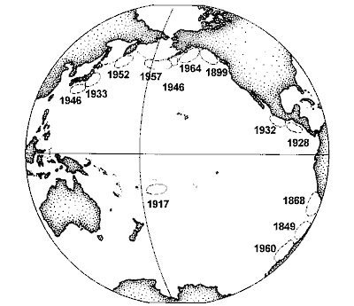
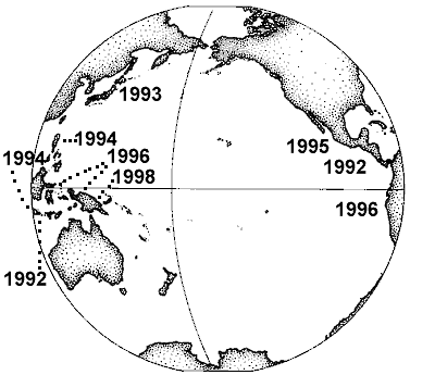
Tsunamis At intervals of from 5-15 years, and often without prior warning, the
sea begins to heave and churn, sometimes receding to bare its floor, or
suddenly rising far beyond the normal range of wave and tide. Flooding
over breakwaters, tearing ships from their moorings, they leave wide spread
destruction to shoreline habitations and facilities. From the map one can
see that large tsunamis are rather rare. 13 of these were recorded over
a time span of 110 years! (Japanese: tsu, "harbour," and nami,
"wave"). The map shows the origin of major tsunamis in the Pacific Ocean
from 1840 to 1960.
Tsunamis are caused by undersea earthquakes, seabed slides, or large
volcanic eruptions (Krakatoa 1883), and are therefore equally impossible
to predict. They are formed by a sudden uplift or subsidence of the sea
bottom, as if a large plunger was suddenly moved up or down. The way they
make themselves felt, varies considerably depending on the distance travelled,
their magnitude and the form of the coast. Tsunamis are large waves travelling
at high speed and limited by the narrow 4 km channel between the sea's
surface and the deep ocean floor.
Many of a tsunami's properties can be
understood with our knowledge of waves. In earlier subchapters on this
page, reference has been made to tsunamis:
The amplitude of a tsunami depends on the size of the original disturbance
and distance travelled. A tsunami wave behaves much the same as the widening
circle radiating out from a pebble's plunge. As the circle widens, the
wave's crest lengthens and its height decreases proportionally to the square
root of distance travelled. After about 6700 nautical miles (12,000 km)
it reaches minimum amplitude, after which it starts focusing again under
the influence of coriolis forces and the curvature of Earth. At sea a tsunami
is hardly noticeable even though it travels so fast, typically rising less
than a metre over a period of 10-30 seconds. Such movement is easily concealed
by local waves.
The speed of a tsunami wave is limited by the depth of the sea,
to about 450 knots (830 km/hr) in the Pacific Ocean.
A tsunami of 4000m deep, bounces off the continental shelf, producing
a variety of wave forms. The continental shelf of 100m is a very shallow
area for these waves and they rise, form steep crests and very large
horizontal water movements, which over-run low lying areas, rip boats
from their moorings and may bare the sea to a depth of 5m or splash against
the coast to a height of 20-30m. The first tsunami wave is not necessarily
the worst.
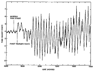
The picture shows a recording of the Chilean tsunami
wave of 22 May, 1960, as it was observed at Acapulco, Mexico, showing vertically
the tide height in feet and horizontally time in hours. The first waves
were less than half a metre high but three hours later many oscillations
of about 1.5m occurred. With some 20 crests in 10 hours, the waves oscillated
quite slowly but regularly. Perturbations of this nature cause large coastal
and harbour currents. Compared with a typical tidal oscillation of 2m in
12.4 hours, the tsunami currents could have been 15 times stronger than
normal tidal currents.
The source of this earthquake in 1960 extended over a
distance of about 1,100 kilometres along the southern Chilean coast. Casualties
included about 5,700 killed and 3,000 injured, and property damage amounted
to many millions of dollars. Seismic sea waves excited by the earthquake
caused death and destruction in Hawaii, Japan, and the Pacific coast of
the United States.
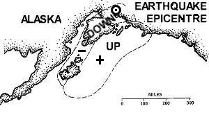
Dr
William Van Dorn (1974) gave the following account of the great earthquake
of 28 March 1964 on southeastern Alaska, and its tsunami:
The volume of water displaced defies imagination. It
involved a dislocation averaging 6 feet (1.8m) vertically over 100,000
square miles - thrice the size of Florida! About half this area was on
land, and subsided; the other half, which included the entire 100-mile
wide shelf bordering the Gulf of Alaska, was bulged upward - in some places
as much as 50 feet (15m). The resulting mound of water poured off the shelf
for two hours, and fanned out over the Pacific, creating widespread damage
as far south as Crescent City, California, 1200 miles distant, where half
of the business district was swept away.
Although this was by no means the most destructive
tsunami in historical times, five of Alaska's seven largest communities
were devastated by the combination of earthquake and wave damage. Its fishing
industry and most seaport facilities were virtually destroyed, and only
massive federal aid and years of effort have sufficed to restore its crippled
economy.
As a long-time student of tsunamis, I flew to Alaska
within 24 hours of the quake, and made a ten-day aerial tour of the entire
region affected, traveling by helicopter, navy aircraft and chartered bush
plane. Among accounts of calamities too numerous to mention, is one of
particular interest to mariners. Most of the Alaskan crab fleet was at
anchor in Kodiak harbour when they received belated warning of "fifty-foot
waves" passing Cape Chiniak, twenty miles to the south. Getting rapidly
underway, they were well out into Chiniak Bay when they encountered the
first incoming crest, estimated to be thirty feet (9m) high and breaking.
The next instant they were making 16 knots (30 km/hr) sternway, and were
carried over a mile back into the harbor, over a protective mole, and on
up into the center of the waterfront business district. The crab boats,
being rather stoutly constructed, were not appreciably damaged by this
excursion into unfamiliar territory, but a number of buildings were knocked
down by their gyrations.
The lesson here is that the fleet was within the epicentral
area of the earthquake, which was plainly felt by everyone. The first waves
arrived some 45 minutes later. Had the fleet put to sea directly after
the earthquake warning instead of waiting for further advisement, the catastrophe
might have been avoided.
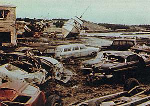
Some of the damage wrought by the 1964 Alaskan tsunami. Photo
source US Geological Survey.
It is interesting but sad to note what happened to the
old town of Valdez, which was built on unconsolidated and unstable deltaic
sands and gravels. The shock waves from the 1964 earthquake, running ahead
of the tsunami, caused the sediments under the waterfront area to spontaneously
liquefy, causing a large section of the delta to slump into Port Valdez.
Not only did this destroy the township, but it also displaced a large volume
of water, generating a local tsunami. Since all of this occurred before
the earthquake shaking ended, the town had no warning at all, and all people
on the town docks at the time were killed by the tsunami. The combined
effects of the earthquake, and the 9-12m local tsunami destroyed most of
the waterfront and caused damage a considerable distance inland. To make
things worse, the forces caused the tanks at the Union Oil Company to rupture,
which started a fire that spread across the entire waterfront, finishing
off the few structures still standing.
Earthquakes
and tsunamis could be monitored by sea-based monitoring stations. By placing
these along seismically active zones, they could warn immediately after
a potential earth quake occurred and when a tsunami wave passes by. By
placing sensors on the bottom of the sea, large waves could be detected.
Normal storm waves do not reach deep enough but a tsunami's long wave would,
even though its amplitude might be very small. By means of satellite communication,
the early warning signals could be transmitted to a tsunami co-ordination
centre, with direct connections to coastal tsunami warning centres.
The map shows all major earthquakes of the 1990s as tabled
below (Source: Scientific American, May 1999):
Date
Place
Max wave
Fatalities
2 Sep 1992
Nicaragua
10m
170
12 Dec 1992
Flores Island
26m
>1000
12 July 1993
Okushiri, Japan
31m
239
2 June 1994
East Java
14m
238
14 Nov 1994
Mindoro Island
7m
49
9 Oct 1995
Jalisco, Mexico
11m
1
1 Jan 1996
Sulawesi Island
3.4m
9
17 Feb 1996
Irian Jaya
7.7m
161
21 Feb 1996
North coast of Peru
5m
12
17 July 1998
Papua New Guinea
15m
>2200
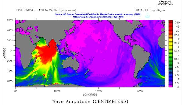
Why was the Sumatra tsunami
so devastating? The Sumatra-Andaman Islands
Earthquake on December 26, 2004, happened in an area with high population
densities along the coasts where it struck with maximal force (see red
colours in the simulated image below). Yet some nations were more so affected
than others. Why?
It has escaped scientists' attention
that the worst affected areas had two things in common: they have neither
experienced hurricanes nor tides. Thus people lived dangerously close to
the water and often on ships that would not be seaworthy in areas where
tropical cyclones are common. The following two maps illustrate the point:
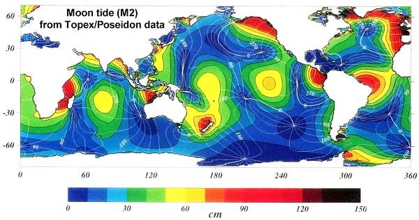
The
above map of the main tide component, the moon-tide, shows where the tide
is zero or very small (dark blue areas). One can see that this is the case
between Aceh (Sumatra) and Ceylon (Sri Lanka). In such areas the tide has
never been able to shape the land as it does for instance where the tide
is between 2-3m, as in the area north of Sumatra. The moon-tide is like
a tsunami, happening twice daily. Combined with waves, and particularly
those from storms, tides then erode the shoreline out, until a shore profile
results that also resists tsunamis. On such coasts, a tsunami won't be
able to run inland as far as it did in Aceh, resulting in less damage and
fewer fatalities.
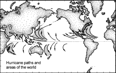
Now notice that the same
area is also located on or very close to the equator where hurricanes cannot
happen because there is not enough coriolis
force or spin to force winds into circular paths. Hurricanes
do not happen either, north of their warm water zones.
Study both maps to find
other tsunami-sensitive areas, such as north and west-Japan. The March
2011 tsunami indeed caused predictably much damage where the coast never
experienced substantial tides nor storms.
Also read Tsunami by Frank I Gonzalez. Scientific
American, May 1999. (Available from the Seafriends library)
Visit a page on tsunamis and good
advice for survival.
Mega-tsunamis Based on findings and projections of British geologist
Simon Day, the BBC television programme, in October 2000, screened a disturbing
documentary about the possibility of a mega tsunami arising from a collapse
of the Cumbre Vieja volcano on the island of La Palma in the Canarias archipelago.
The resulting shock wave could send a massive wave all across the Atlantic
Ocean, to swamp large areas of America's east coast. Headlines in newspapers
ran like this:
It was a scene straight from a disaster movie
but a disaster on such an epic scale that even the most flamboyant Hollywood
director would hesitate to suggest it might ever happen. Imagine being
transported in your tiny fishing boat on the crest of a wave 1,600ft high
- three times the height of Blackpool Tower- over forests and glaciers
and living to tell the tale. That is what happened to fishermen Howard
Ulrich and his son Sonny on a July evening in 1958 in Lituya Bay, Alaska.
On 8 July 1958 a 7.5 magnitude (others say 8.3) earthquake
occurred along the Fairweather Fault, running along a trench near Lituya
Bay. As a result, a massive land slide originating from 1000m altitude,
while possibly shifting 30 million m3 of earth, plunged into the bay. The
wave it caused, denuded the sides of the bay up to 516m high near the slide,
and the rest of the shoreline between 200 and 30m high as it moved away
towards the entrance. Simon Day extrapolated that if the entire west flank
of the Cumbre Vieja mountain did the same, but with 1000 times more earth,
it would send 650m shockwaves across the ocean, that would still be 40-50m
high when reaching the USA, 6500 km away.
But computer models do not agree, and tsunami expert
Charles Mader advised that the wave would have a short wave length (less
than 10 minutes), rapidly decaying to a deep water wave before it reached
the US.
The La Palma story helps us to
brush up our knowledge of the physics of waves (see above). Whether originating
from an underwater land slide, the explosion of a volcano or the impact
of an asteroid, waves still obey the same physical laws.
Impulse and energy: There are two aspects of a
disturbance that we need to distinguish: suddenness (velocity, v)
and volume (mass,
m). The two combined create impulse or impact
(v x
m), and kinetic energy (0.5 x v x v x
m).
Impulse determines how much matter will be moved by the disturbance (water
and earth and buildings), which is often more destructive than the energy
content of the disturbance. Think for instance of the huge energy contained
in normal moon tides, which causes no harm because tides move slowly.
Physical limitations: The critical element is how
a wave (a surface wave) moves through a narrow channel of 6000 km long
but only 4km deep, the Atlantic Ocean. And there's an obstacle in the middle
as well, the Mid-atlantic Ridge. Such waves are physically limited to travel
no faster than 700-800 km/h, giving them a wave period of around 2 minutes
(120 sec) and a wave length of 26 km (see equations above). This narrow
channel soon dampens the quicker components of a disturbance. Think for
instance of a sudden movement, like throwing a pebble into a pool. As the
pebble displaces water outward, it also produces a wave moving inward and
upward, which dissipates most of the energy and impact. So, as far as underwater
tsunamis are concerned, the long-distance component is proportional only
to the amount of earth shifted (in 2 minutes). An underwater slip or slump
consists of a volume of mud sliding down hill. Since the velocity of such
incidents is roughly the same, their impact depends on mass only.
Impacts from outside, however, can produce larger waves.
Asteroids are a point in case. They travel at speeds between 10-70 km/s
(usually around 20 km/s=70,000 km/h), such that a 1km3 asteroid can produce
a 70-90m deep water wave 100 km away from impact, but such impacts occur
about once in 100,000 years. (Please note that not all scientists agree
on these figures)
Diminishing with distance travelled: Once the wave
is on its way, it fans out over 180 degrees, becoming weaker as it 'dilutes'
over a larger area, while encountering resistance as well. The wave weakens
roughly inversely to distance travelled, thus at 1000km distance, the wave
is 100 times (computers say 200 times) smaller (its energy 10,000 times
less) than it was at 10km distance. The 1964 tsunami in Alaska shifted
some 500 km3 of earth, starting a deep water wave of 30m, which diminished
to 0.3m at 1500 km distance, then increased to 3-6m as it ran up the shallows.
This wave caused substantial damage to boats, piers and the business district
in Crescent City, California. The 1960 Chilean earthquake may have shifted
over 1500 km3 (my estimate), causing extensive coastal damage locally and
as far away as Hawaii (15 hours) and Japan (22 hours), but was hardly noticeable
in New Zealand (18 hours later).
Mountain slide: According to Simon Day, in the
case of the Cumbre Vieja, as much as 500 billion tonnes (200 km3) of earth
could suddenly slide into the ocean, creating 650m waves locally. In his
model he used a solid wedge, which slid rapidly, but natural slumps break
up and slide more gradually. Since earth is between 2 and 3 times 'heavier'
above water, land slides can acquire 2-3 times more momentum from their
mass, and another similar amount from their higher speed, totalling perhaps
10 times. This would suggest that the La Palma island mega tsunami would
equate to an under water slump of no more than 2000 km3.
Meteorites: Meteorite impact studies suggest that
such an impact (equal to 10,000 Mt TNT) equates to that of a 500m diameter
asteroid (0.037 km3). Such waves would diminish to less than one metre
at 6000 km, but would still be capable of causing much damage through their
variable 'run-up' effect.
Run-up: Tsunamis cause more or less damage depending
on how they run up the coast. As they enter shallow water, the waves rise
and slow down. Depending on the shape of the sea bottom and that of bays,
their size increases between two (normal) and forty times (very abnormal).
A 1m wave could thus rise to 2m (normal rise, within normal tidal range)
or 40m, causing extreme damage very locally.
Conclusion: although scientific knowledge and computer
models are not able to disprove Simon Days' findings, common sense evaluation
of the situation makes 40-50m tall waves swamping America and Britain,
highly unlikely.
Seiches and bores Oscillations of lake water levels were first studied in Lake Geneva
in Switzerland, where they are called seiches. Seiches are standing
waves that slosh to and fro in deep lakes, from one end to another. Changes
in barometric pressure or other disturbances may start such standing waves.
The speed and length of standing waves is given by the basin's depth and
the distance between shores. In this manner each enclosed body of water
has its own standing wave characteristics.
At the entrances to semi-enclosed harbours, waves or an incoming tide
may start oscillations that bounce to and fro between the shores of the
harbour. Such oscillations can be started by large wave trains, gusty winds
and may damage moored boats.
When a spring tide comes in on a gently sloping shore which narrows
into a river entrance, the tide currents can become strong enough to displace
outflowing water and to rise up, forming a fast moving vertical wall of
water. Such a wave, characterised by a surge of water moving swiftly upstream,
headed by a wave or series of waves, is called a bore (Old-Nordic
bara=wave.
A bore is also called an eagre).
A famous bore, known as the Mascareton the French river
Seine, forms on spring tides and reaches some 50km inland. The bore can
reportedly outrun a horse (about 35km/hr).
A rather destructive bore enters the Amazon river and is called pororaca
meaning "great roar" because it can be heard long before arriving.
Other famous bores are found in the Fu-chun River in china, the Severn
in England and the Petitcodiac River in New Brunswick, Canada.
Internal waves Internal waves are a class of gravity waves to be found almost entirely
under the surface. They propagate along the boundaries of layers of water
with differing densities:
A thermocline forms when the sea heats up. Warm water being lighter
than cold water, remains on top. A temperature gradient develops into a
sharp thermocline. The water on top may be 4 degrees warmer and 0.2% less
dense.
Fresh water flowing from large rivers, is lighter than salt water
and stays on top of it for many kilometres and several metres depth. In
fiords, the fresh water may form a 5m deep layer. The fresh water is about
3.5% less dense.
Because of the small difference in density between such layers, the
corresponding restoring force for gravity waves is much less than that
for surface waves (which is the weight difference between water and air).
From the speed equation for gravity waves, it follows that internal waves
move much more slowly but at a fixed rate, which also depends on the depth
of the boundary layer. For instance, for a thermocline at 10m with a difference
of 0.15% density, the wave velocity would be 0.4m/s (1.4 km/hr). For a
fresh water layer of 5m depth, the wave velocity would be 1.3 m/s (6.1
km/hr).
Internal waves require very little energy to be set in motion. The tidal
current flowing over a sea bottom discontinuity could create packets of
internal waves. Internal wave amplitudes of tens of metres and periods
of up to 12 hours have been measured in the open ocean. Internal waves
can also produce standing waves (like seiches) in enclosed bays. Because
these waves are difficult to observe, very little is known about them.
The wave phase velocity
of gravity waves in a two layer ocean is given by:
c x c = g x d x (p2
- p1) / p2 where c = phase velocity (m/s), g = acceleration
of gravity (9.8 m/s/s), d = thickness of the upper layer (m)
p1 = density of top layer (g/cm/cm), p2
= density of deep layer (g/cm/cm).
From this formula it follows that the wave velocity of internal
waves depends both on the thickness of the layer and the relative difference
in density between the two layers.
It is interesting to note that the water particles above
the layer move clockwise whereas those below move counter clockwise.
Although
they did not know what caused it, seamen were familiar with a strange phenomenon,
called deadwater. When travelling into a fiord, or near an ice shelf,
their slow ships seemed to come to a halt, and even at full power they
would only make very slow headway. Later, scientists discovered its cause,
an internal wave created by the ship's movement. It appears as if the ship
is travelling uphill against the heavier salt water crest. A 1000 tonne
ship could experience it as a 20 tonne drag, because salt water of 3.5%
is about 2% denser than fresh water.
Internal waves arising from temperature or saline differences,
can reach magnitudes of 40m, bringing deep nutrient-rich water right into
the shallow light zone where it causes sudden and dense plankton blooms.
The polar explorer Fridtjof Nansen, leader of the Norwegian
North Polar expedition to the Arctic in 1893-1896 reported the following
experience aboard the small research vessel Fram, as he was tracking the
ice dirft across the Arctic:
On tuesday, August 29th, 1893, the Fram got into open
water in the sound between the Isle of Taimur and the Almvist Islands and
steamed in calm water through the sound to the north-east. . . . We approached
the ice to make fast to it, but the Fram had got into dead-water, and made
hardly any way, in spite of the engine going at full pressure. It was such
slow work that I thought I would row ahead to shoot seal. . . . the speed
must have reduced to 1 - 1.5 knot in the dead-water. . . The water at the
surface was almost fresh, whereas through the bottom-cock of the engine
room we got perfectly salt water.
In 1963, the nuclear submarine USS Thresher was lost
with all hands on board. Prior to the sinking there had been no indication
of equipment malfunction or unusual storm weather. While submerged, submarines
attain neutral buoyancy by flooding or jettisoning seawater from a series
of ballast tanks. An effective way for a submarine to avoid detection by
suface vessels is to dive and cruise silently along density discontinuities
(pycnoclines), which tend to reflect the engine noise downward and sonar
pulses from above upward. Navy scientists speculate that the USS Thresher
was probably cruising along a pycnocline when it encountered a large internal
wave. Because of its neutral buoyancy, it is thought that the submarine
suddenly slid down the wave's back side, down to greater depths. Unable
to compensate for this sudden fall, the submarine exceeded its design depth
and imploded with loss of all life.
Source: Paul R Pinet: Oceanography.1992.
How waves damage the rocky
shore When
waves roll along in deep water, the water particles hardly move at all,
relative to each other. But once a wave enters shallow water, the situation
changes. At its foot, the wave meets a boundary that won't move and as
a consequence, the water particles move relative to that boundary. At its
top, the wave breaks, sending rushes of water forward. At these two points,
the bottom and the top, the coast appears under severest attack of the
waves. Depending on the amount of exposure and depth, the rock face is
ground to a shape of minimal erosion, such that any point deviating from
this shape, would erode faster than its surroundings. Although affected
by the vagaries of rock hardness and homogenity, a typical coastal profile
emerges.
In deep water, the profile plunges down vertically to over 20m depth.
These steep rock walls bounce waves back into sea, without absorbing much
of their energy at all. So erosion rates near the surface are low. In moderately
deep water, a drop-off may exist but the slope becomes more gradual. Platforms
are a consistent feature of the shore. In the diagram with actual north-facing
shore profiles, one can see a platform developing in the sea urchin habitat,
and perhaps also one lower down. Because the urchins graze their patch
thoroughly, the stoneleaf algae (Lithothamnion sp) thrive, protecting
the rock. What are the forces of the waves that carve these shapes?
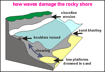
When
a mass of water is on the move, it is much harder to stop than air. Water
is about 800 times heavier than air. So it can turn and lift boulders.
Enormous pressure waves can develop when water is squeezed into a crack
or cave. But most damage is caused by the friction of water, as it races
along a rock face (shearing). Creatures attached to the rock may be ripped
and their bodies washed up on a beach. At the bottom, where the sand or
pebbles can move freely, rocks and organisms become sand-blasted and erosion
here is high during large storms. The freely moving sand may be deposited
on deep rock flats, smothering the attached organisms.
Ironically, scientists discovered that the hardness of the rock has
little bearing on its rate of wear [Taylor,
2000]. Such findings go against all logic, but nature
can be perplexing. What is often overlooked, is the protection afforded
by organisms living on the rock. Even a thin scum of algae prevents water
and sand from touching its surface, and although the living skin may suffer
damage, it is capable of repairing itself. The 'living skin' idea could
explain why soft rock is protected relatively better (because it is easier
to attach to), than hard rock such as granite (is too smooth for attachment).
It could explain the existence of platforms (because these are the best
form for sun-loving plants) and why the shoreline erodes so slowly despite
the enormous forces occurring in the wave zone. It could also explain why
shaded coasts wear faster (because the protective film grows slower), and
why coastal erosion is increasing everywhere in the world (because protective
organisms are disappearing due to pollution and mud).
Among the rock-protecting creatures one can find both animals (that
don't need sunlight) and plants (that do need sunlight). Animals: barnacles,
mussels. Plants: various matting algae, pink paint (Lithothamnion sp),
large algae.
Amongst the living skin, also creatures can be found that are capable
of drilling into soft rock. They do so by means of scraping, assisted by
excreting acids. Particularly limestone-rich rocks can be attacked in this
way.
Reader please note that the above are my own observations
that have not been confirmed by scientific method. Floor Anthoni Taylor,
Anna. Geography Dept, Univ Canterbury: Erosion of shore platforms,
East Coast, South Island, New Zealand. International Coastal Symposium
2000, Rotorua, New Zealand.
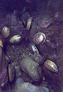
These live paua shells (abalone Haliotis iris), living
close to the bottom of a shallow cave in northern New Zealand, have been
abraded by shingle, showing their finely polished nacre. It was like happening
upon Aladdin's cave of treasures. The rocks were finely polished too.
By night, pauas leave their sleeping places to browse
the rocks that are exposed to sunlight by day.
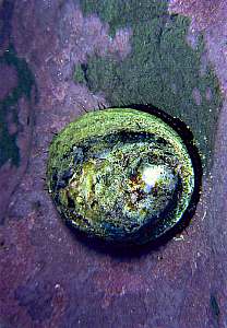
Close-up of a polished paua shell. Notice that the rock is
covered by a rock-hard pink alga (Crustose Calcarean Alg CCA), affectionately
called 'pink paint' (Lithothamnion sp.). It is apparently hardy
and resilient enough to repair damage from both the grazing of paua and
abrasion from shingle. This most amazing rock lining lives from shallow
rock pools, down to 50m depth. Here it thrives in the darkness of this
cave.
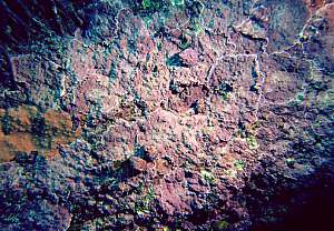
Close-up of pink paint (Lithothamnion sp) on the side
of a rock at 20m depth. The edges of each plant (leaf) can clearly be distinguished.
Top left, part of a kelp's holdfast (Ecklonia radiata) is seen.
A number of top shells can be distinguished, grazing the pink paint.
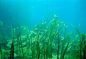
These young kelp plants had settled in shallow water (6m),
the domain of the sea urchins. During a storm (cyclone Fergus), their canopies
were stripped off, causing almost full mortality. It is amazing to see
how sharp the boundaries of storm damage are. Only one metre deeper, none
of the kelp plants was affected.
 Tsunamis
 Dr
William Van Dorn (1974) gave the following account of the great earthquake
of 28 March 1964 on southeastern Alaska, and its tsunami:
Dr
William Van Dorn (1974) gave the following account of the great earthquake
of 28 March 1964 on southeastern Alaska, and its tsunami:
 Earthquakes
and tsunamis could be monitored by sea-based monitoring stations. By placing
these along seismically active zones, they could warn immediately after
a potential earth quake occurred and when a tsunami wave passes by. By
placing sensors on the bottom of the sea, large waves could be detected.
Normal storm waves do not reach deep enough but a tsunami's long wave would,
even though its amplitude might be very small. By means of satellite communication,
the early warning signals could be transmitted to a tsunami co-ordination
centre, with direct connections to coastal tsunami warning centres.
Earthquakes
and tsunamis could be monitored by sea-based monitoring stations. By placing
these along seismically active zones, they could warn immediately after
a potential earth quake occurred and when a tsunami wave passes by. By
placing sensors on the bottom of the sea, large waves could be detected.
Normal storm waves do not reach deep enough but a tsunami's long wave would,
even though its amplitude might be very small. By means of satellite communication,
the early warning signals could be transmitted to a tsunami co-ordination
centre, with direct connections to coastal tsunami warning centres.
 The
above map of the main tide component, the moon-tide, shows where the tide
is zero or very small (dark blue areas). One can see that this is the case
between Aceh (Sumatra) and Ceylon (Sri Lanka). In such areas the tide has
never been able to shape the land as it does for instance where the tide
is between 2-3m, as in the area north of Sumatra. The moon-tide is like
a tsunami, happening twice daily. Combined with waves, and particularly
those from storms, tides then erode the shoreline out, until a shore profile
results that also resists tsunamis. On such coasts, a tsunami won't be
able to run inland as far as it did in Aceh, resulting in less damage and
fewer fatalities.
The
above map of the main tide component, the moon-tide, shows where the tide
is zero or very small (dark blue areas). One can see that this is the case
between Aceh (Sumatra) and Ceylon (Sri Lanka). In such areas the tide has
never been able to shape the land as it does for instance where the tide
is between 2-3m, as in the area north of Sumatra. The moon-tide is like
a tsunami, happening twice daily. Combined with waves, and particularly
those from storms, tides then erode the shoreline out, until a shore profile
results that also resists tsunamis. On such coasts, a tsunami won't be
able to run inland as far as it did in Aceh, resulting in less damage and
fewer fatalities.
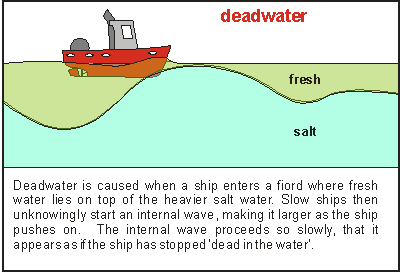 Although
they did not know what caused it, seamen were familiar with a strange phenomenon,
called deadwater. When travelling into a fiord, or near an ice shelf,
their slow ships seemed to come to a halt, and even at full power they
would only make very slow headway. Later, scientists discovered its cause,
an internal wave created by the ship's movement. It appears as if the ship
is travelling uphill against the heavier salt water crest. A 1000 tonne
ship could experience it as a 20 tonne drag, because salt water of 3.5%
is about 2% denser than fresh water.
Although
they did not know what caused it, seamen were familiar with a strange phenomenon,
called deadwater. When travelling into a fiord, or near an ice shelf,
their slow ships seemed to come to a halt, and even at full power they
would only make very slow headway. Later, scientists discovered its cause,
an internal wave created by the ship's movement. It appears as if the ship
is travelling uphill against the heavier salt water crest. A 1000 tonne
ship could experience it as a 20 tonne drag, because salt water of 3.5%
is about 2% denser than fresh water. 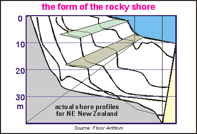 When
waves roll along in deep water, the water particles hardly move at all,
relative to each other. But once a wave enters shallow water, the situation
changes. At its foot, the wave meets a boundary that won't move and as
a consequence, the water particles move relative to that boundary. At its
top, the wave breaks, sending rushes of water forward. At these two points,
the bottom and the top, the coast appears under severest attack of the
waves. Depending on the amount of exposure and depth, the rock face is
ground to a shape of minimal erosion, such that any point deviating from
this shape, would erode faster than its surroundings. Although affected
by the vagaries of rock hardness and homogenity, a typical coastal profile
emerges.
When
waves roll along in deep water, the water particles hardly move at all,
relative to each other. But once a wave enters shallow water, the situation
changes. At its foot, the wave meets a boundary that won't move and as
a consequence, the water particles move relative to that boundary. At its
top, the wave breaks, sending rushes of water forward. At these two points,
the bottom and the top, the coast appears under severest attack of the
waves. Depending on the amount of exposure and depth, the rock face is
ground to a shape of minimal erosion, such that any point deviating from
this shape, would erode faster than its surroundings. Although affected
by the vagaries of rock hardness and homogenity, a typical coastal profile
emerges.
 When
a mass of water is on the move, it is much harder to stop than air. Water
is about 800 times heavier than air. So it can turn and lift boulders.
Enormous pressure waves can develop when water is squeezed into a crack
or cave. But most damage is caused by the friction of water, as it races
along a rock face (shearing). Creatures attached to the rock may be ripped
and their bodies washed up on a beach. At the bottom, where the sand or
pebbles can move freely, rocks and organisms become sand-blasted and erosion
here is high during large storms. The freely moving sand may be deposited
on deep rock flats, smothering the attached organisms.
When
a mass of water is on the move, it is much harder to stop than air. Water
is about 800 times heavier than air. So it can turn and lift boulders.
Enormous pressure waves can develop when water is squeezed into a crack
or cave. But most damage is caused by the friction of water, as it races
along a rock face (shearing). Creatures attached to the rock may be ripped
and their bodies washed up on a beach. At the bottom, where the sand or
pebbles can move freely, rocks and organisms become sand-blasted and erosion
here is high during large storms. The freely moving sand may be deposited
on deep rock flats, smothering the attached organisms.