By Dr J Floor Anthoni (2000)
www.seafriends.org.nz/oceano/currents.htm
The world consists almost for 80% of water
(oceans). Not surprisingly, these play a major role in the world's natural
affairs. For instance, all rain originates from the oceans. Ocean temperatures
are stable from day to day and change slowly with the seasons, as opposed
to land temperatures. This chapter explores the circulations of water,
in the air, in surface currents and in deep ocean currents. Because the
planet rotates, all movement on its surface experiences a mysterious force,
the Coriolis deflection. How does it work? How is water transported onto
continents? How do surface currents influence climate? What is El Niño
and how does it work?
.
please note that this document covers: part1
air circulation and part2 ocean circulation
(this page)
Solar energy reaches the planet on its outer
atmosphere. Some is reflected and some reaches the surface through a number
of natural filters that protect life on earth. What reaches the surface,
warms it up and makes plants grow. Atmosphere, ionosphere, exosphere, Van
Allen radiation belts, magnetosphere, satellites, orbits.
The solar radiation warms the surface of the
planet and its atmosphere. Various gases filter incoming and outgoing radiation,
resulting in a planet which is liveable. Solar radiation, blackbody, terrestrial
radiation, atmospheric gas filters, absorption and shade, photosynthetic
absorption, seasons.
The way air circulates in the atmosphere is surprisingly
complicated. It governs the climate all over the world. During summer and
winter, predictable areas of high and low pressure develop and the winds
associated with them. General global circulation, Hadley Cell, jet stream,
deserts,
The water retained as moisture in
the air, brings life to the continents where it circulates almost independently
from that above the oceans. Humans have disrupted this water cycle by changing
forests into agriculture and urban development, which in turn changed the
climate.
Currents and winds are deflected by Coriolis
forces. How do they work? How do winds and currents react? What is an Ekman
Spiral? How do layers of air or water move?
The surface currents are driven by wind blowing
over the ocean's surface. Where winds blow predictably, these currents
are predictable also their associate climates. Map and names of currents.
Most of a water particle's life is spent in the
deep sea and nutrients befall the same fate. Yet at places on Earth, the
cool bottom water is able to resurface and sea life here is bountiful.
Wind-driven currents depend on the vagaries of
climate and climate depends on ocean currents. An introduction to the El
Niño climate variation that affects nearly the entire world's climates.
-- previous page -- next
page -- 20000825,20011124,20030130,20030328,20060806,20060826,20070718,
The water
circulation
What makes planet Earth so exceptional, is a very common substance called
water. It is available in massive quantities in our oceans, ice caps, lakes
and rivers. It cycles through the air and through the bodies of every living
creature.
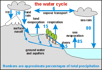
In the diagram this water cycle is shown, with percentages attached
for each component (Total amount of water on Earth= 1.4E9km3. Evaporation
100%= 4E5km3). As one can see, the circulation above land is essentially
separate from that above the seas, but all water comes from the seas, since
rivers eventually drain all terrestrial water back into it. About 6% is
exchanged between the two. Note that the fertility of the land thus depends
very strongly on how well the water cycles above the land. Most of the
terrestrial cycled water is held in the living tissues of plants. Evaporation,
being part of the cycle inside these plants, is part of the chemistry that
makes plants grow, and that determines the biological productivity of the
land. It is not surprising therefore, that natural ecosystems have developed
ways to soak up rain, dew and snow and to store the water for gradual use.
Water, 'dissolved' in air as vapour, has a major influence on how the
planet's temperature is stabilised. Everywhere on Earth, winds flow from
warm to cold and back again, to transport the equator's heat to the poles.
Without water vapour, air alone would not be able to do so, unless it flowed
much faster than experienced today. The water's secret is held in its heat
capacity (one calory heats one gram of water by one degree), and more so
in the amount of heat required to evaporate it (about 400 calories per
gram). Every gram of water evaporated, cools its environment by 400 calories.
The water vapour rises high into the atmosphere, exchanging heat with the
cool air, only to condensate back into rain again. In this manner, massive
amounts of heat are exchanged with and between all layers of the troposphere
(where surface winds blow).
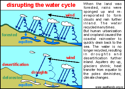
Disrupting
the water cycle Through deforestation, agriculture and urbanisation, the terrestrial
water cycle has been disrupted substantially, resulting in world-wide climate
change. The diagram shows how. In the top part, it shows the natural situation,
before Man changed the land. The land was forested, and the forests acted
like a large sponge. Moisture for the land arrives mainly from the sea,
precipitating in the coastal zone. In the forested situation, only a small
part of the rain drains back through rivers to the sea. Most evaporates,
rising to form clouds, only to rain down further inland. Successively the
rains reach the centres of the continents, although in lesser volumes than
at the coast. As a result, the centres of all continents have always consisted
of arid land.
Since Man has deforested the land for agriculture and urbanisation,
the natural forest-sponge has disappeared, and the coastal rains flow back
immediately to the sea. The amount evaporated from the coastal zone became
much less, resulting in much less rain to fall further inland. This also
warmed up the deforested lands, with the result that the clouds rose higher
than normal, reluctant to condensate back into rain. The centres of the
continents became expanding deserts. Note that it was sufficient to develop
only the coastal zone to achieve this effect!
The reduction in moisture had another major effect on climate, since
most of the heat transport from equator to poles happens by the repeated
cycles of evaporation, transport, condensation and precipitation (rain).
With less moisture available in the air above continents, the heat transport
diminished, resulting in warmer equator, cooler poles and warmer continents.
The temperture stabilising function of the winds also became less, and
winds 'compensated' for this by flowing faster. It resulted in climate
change notable for its heavy rains, flooding of rivers, inland droughts
and more severe but stable winds, higher tropical and desert temperatures
and cooler poles.
Reader please note, that this aspect of climate change has not received
sufficient publicity and interest, all attention being focused on global
warming instead. But here is something interesting news to support our
findings.
Rising
clouds leave forests high and dry 26 March 2003 - Exclusive
from New Scientist Print Edition
The base of clouds that form
over the north-eastern states of the US have been getting ever higher over
the past 30 years. It is a change that could severely disrupt forests in
the Appalachian Mountains. Rising cloud ceilings have been spotted before
in other parts of the world. In 1999, scientists found that clouds in the
Monteverde cloud forests of Costa Rica were not forming as far down the
mountains as they once did.
This effect was initially
attributed to rising sea temperatures in the Caribbean, caused by global
warming, but in 2001 Robert Lawton of the University of Alabama in Huntsville
reported that the main driving force behind the change
was warmer, drier air moving up from the lowlands, which had been cleared
of trees. The rising cloud ceiling has seriously damaged the cloud
forest ecology, causing an alarming decline in populations of toads and
frogs.
Now Andrew Richardson of
Yale University in New Haven, Connecticut, and his colleagues have uncovered
a similar trend in the temperate Appalachian ecosystem. The study was prompted
by an intriguing observation by team member Thomas Siccama in the 1960s,
when he regularly travelled through the mountains. "He noticed that in
the fall, a lot of the time the clouds were at a level that coincided with
the change from deciduous to coniferous forests," says Richardson. Concerned
about the effect of a rising cloud ceiling on this forest boundary, the
researchers examined data from 24 airports located along the south-west
to north-east axis of the Appalachians. Airports routinely measure the
cloud ceiling because it is important to pilots.
Richardson's team found that
in the 18 most northerly airports, the cloud ceiling
has climbed an average of six metres per year since 1973. "Over
30 years, that's 180 metres, which is about six tree heights," says Richardson.
"It is pretty stunning."
Scavenged water
With the cloud base moving up,
many spruce and fir trees will not be able to scavenge water from the clouds.
"That's got all sorts of implications for hydrology in the mountains,"
says Richardson. Normally, the scavenged water drips down to the forest
floor, but if this supply began to run dry it would immediately affect
moisture-loving animals such as toads and salamanders. If the trend continued,
broad-leafed deciduous trees such as sugar maple and yellow birch could
move up the slope, visibly shifting the deciduous-coniferous boundary.
The study is due to appear in a future issue of the Journal of Climate.
Roger Pielke, a climatologist
at Colorado State University in Fort Collins and a member of Lawton's team,
says that deforestation and urbanisation in the north-eastern US may be
causing the cloud ceiling to rise, just as in Costa Rica, because both
changes lead to warmer air that has to rise higher before it condenses.
Cleaner air, containing a lower level of particulates, may amplify this
effect. Particulates normally act as condensation nuclei, encouraging clouds
to form at lower altitudes. Pielke cautions that because the research data
comes from airports, it may be unduly influenced by the local effects of
urbanisation. "But these are real trends," he says. "If they actually occurred
in the mountains, they would be of concern."
Anil Ananthaswamy
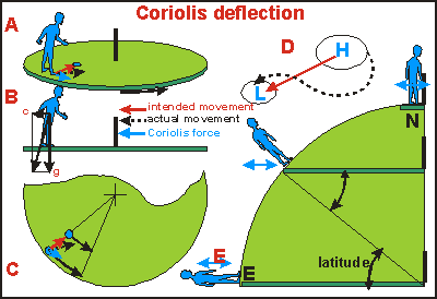
Deflection Because
the Coriolis deflection is a major influence on winds and currents, it
pays to understand it a little better. In traditional old-fashioned playgrounds,
among the swings, see-saws and slides, almost always a rotating platform
was found. Pushing it by its side railing, the 4-5 metre flat disc could
be spun around and one could then jump on to experience and conquer strange
forces that would make a grown man stumble and fall as if he was drunk
(figure A). Note that the platform rotates like the planet, in an easterly
direction, or counter-clockwise when seen from above. The immediate
effect of the spinning platform is a steady force pushing one outward.
It is easily conquered by leaning towards the centre of the disc (Fig B).
The real fun starts when walking around. For every step forward one will
be pushed off-balance, needing several quick correcting steps to recover.
What could the mysterious force be that does this?
It is the Coriolis force, described and formulated
by the French engineer and mathematician Gustave-Gaspard Coriolis in 1835.
He realised that objects resting on a circular platform have different
circular speeds, depending on their distance to the centre. In the centre
the speed is zero, whereas it increases as the radius increases. An object
moving inward (red arrows= path without Coriolis force) would have too
much orbital speed for the new position and would land to the right, in
front of it (dotted black arrows = path with Coriolis force). It
seems as if the object is deflected to the right (Fig C). When moving outward,
the object's orbital velocity will be short of the new position, landing
the object behind, again to the right, of its intended direction.
When moving with the rotation, one's speed would
be too high for the radius, resulting in a push to the right. Moving against
the rotation would reduce one's orbital speed, causing one to fall inward.
In all cases a pull to the right is experienced, no matter where one goes
or where one is on the platform! The mysterious pull appears to depend
only on the platform's rotational speed and the speed of an object relative
to this platform.
Coriolis formulated this force in a simple formula:
pull = 2 x spin x speed (see box below). Because Earth spins
rather slowly, the Coriolis force is correspondingly small. For instance,
a motorbike rider of 100 kg, on a bike of 200 kg, moving at 100 km/hr (30
m/s) would experience a side-ways pull at mid latitudes of only 0.9 kg.
By contrast, gravity pulls him with 300 kg.
At this point it is important to observe that
the Coriolis pull works only in a plane parallel to the rotating disc (blue
arrows), and that up and down movements (jumping) do not invoke it, but
movements parallel to the rotating disc do.
When looking from the north pole down on the planet,
it looks like a rotating disc in fig C, turning counter-clockwise. Thus
all movements on the northern hemisphere are deflected to the right. Likewise
all movements on the southern hemisphere are deflected to the left. Figure
D shows the path of winds travelling from an anticyclone (H) to a cyclone
(L) with right-handed deflection.
Figure E shows a cross-section of the planet with
E the equator and N the north pole. The equator rotates eastward towards
the viewer. The dark green bars are conceptual spinning discs as in figure
B. The blue arrows give the directions of the Coriolis forces (parallel
to the spinning discs). Now it can be seen that moving north-south on the
equator does not invoke Coriolis pull, whereas east-west movements do.
Orbital velocity here is about 1600 km/hr.
At mid latitudes (45º), movements in all
directions invoke about equal Coriolis pull. Near the poles, the Earth's
surface resembles that of a spinning disc most, and here the Coriolis effect
is largest.
A number of other interesting observations can be made.
At the equator, objects moving in the direction of Earth's rotation (west-east)
are deflected upward. Air moving in this manner would make unstable circulation
cells, but moving east to west, air is pushed down, being able to glide
over the surface over long distances. In the Pacific Ocean, this stable
wind produces a stable current (the equatorial current). It too is deflected
down, producing a circulation pattern that maintains the equatorial counter
current at some depth under water. Coriolis forces focus this current to
run beneath the surface as a narrow jet of high velocity. When scientists
first discovered it, they were very surprised, but it could have been predicted
from the way Coriolis forces work in this area.
At mid latitudes, the Coriolis forces do not just deflect winds sideways
but also upward or downward, depending how they run. It produces unpredictable
swirls of wind, high and low pressure areas and fronts.
The Coriolis deflection (force per unit mass) experienced
on the flat spinning disc is equal everywhere, depending only on the object's
velocity v and the rotational spin (radian/sec):
f
=
2 x spin x v, where spin is the Earth's rotational spin of
360 degrees, 2 x pi radians per 24 hours = 7.27E-5 rad/s . f
= 1.45
x v (m/s/kg )
The effect of latitude adds a sine factor as can be seen
in fig. D: f = 1.45 x v x SIN( latitude)
For example: f = 0, 0.25E-4, 0.50E-4, 1.0E-4, 1.45E-4
at latitudes 0, 10, 20, 43, 90 degrees.
The deflection caused by the turning earth is called
geostrophic
(Greek: Geos= Earth, trephos = to turn). Geostrophic wind and geostrophic
currents are examples.
Ekman
spiral The Coriolis force acts on the transfer of movement by friction, from
one layer of air or water to another. In theory, the water's surface is
pushed at a 45 degree angle to the wind, as shown in the diagram for the
southern hemisphere (left-hand deflection). As the movement is transferred
from layer to layer, the speed decreases while the angle increases. Speed
becomes zero in a direction opposing the wind. When all speeds and directions
are taken into account, the net flow of mass is perpendicular to the wind.
This theory explains the movements of water in the open ocean, but near
coasts, water layers are not as free to move according to theory. Here
one finds the water seldom moving further than 30 degrees from the direction
of the wind.
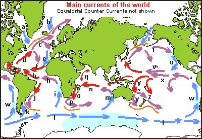
Surface
currents The map and table below show the main surface currents of the world.
Red arrows for warm currents, blue arrows for cold currents and purple
arrows in between. When comparing currents with the average wind maps above,
a good match is found. Monsoon winds that blow in opposite directions for
part of the year, do not produce significant currents. Upwellings are shown
in light blue. They are found mainly where cold currents hug a continent.
In these places no thermocline exists that keeps the water layered (stratified).
Coriolis forces and surface winds make the currents rotate, turning cold
and nutrient-rich bottom water to the surface and carrying warmer water
out to sea. In these places the richest fisheries of the world are found.
The orange lines on the map mark the places where warm water meets
cold water. A front (subantarctic front) is formed because the two water
masses won't mix easily. Cold water is pushed down to the deep ocean and
in the front eddies are formed that bring nutrient-rich water to the surface.
These places are also highly productive.
a Labrador Current
b East Greenland C.
c North Atlantic Drift
d Gulf Stream
e Canary C.
f North Equatorial C.
g Caribbean C.
h South Equatorial C.
i Benguela C.
j Brazil C.
k Falkland C.
l West Wind Drift
m West Australian C.
n South Equatorial C.
o Mozambique C.
p Agulhas C.
q Monsoon Drift
r Kamchatka C./Oya Shio
s Kuro Shio C.
t North Pacific Drift
u California C.
v North Equatorial C.
w Peru/ Humboldt C.
x South Equatorial C.
y East Australia C.
z East Auckland C.
Deep currents Although ocean basins stretch from one pole to the other, a distance
of 20,000 km, they are only 4-5 km deep on average. It is almost unimaginable
that such a thin sheet of water can form layers that mix with difficulty.
Deep ocean water may remain there for 1000 to 2000 years before returning
to the surface. Although the deep ocean circulation is very slow, the amount
of water and the temperature differences involved, play a major role in
the heat distribution of the planet, the weather and human-induced global
warming. We'll first look at the stratification (layering) of water in
a lake.
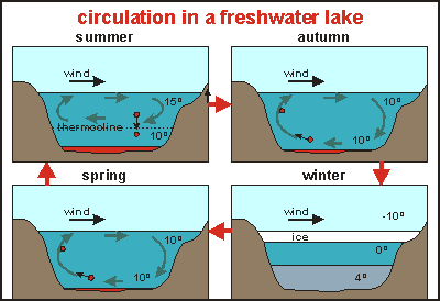
The
diagram shows a cross section through a typical freshwater lake. In summer
the surface water warms up and becomes lighter than the bottom water. Although
wind-induced surface currents stir the water around, they are not strong
enough to mix the entire lake, if it is deep enough. A thermocline develops.
Had the cooler autumn not arrived, the entire lake would eventually have
warmed through by the conduction of heat downward. Organisms living above
the thermocline use up all available nutrients there, which sink to the
bottom layer with their deceased bodies. At one time, the surface water
may become very clear. By contrast, the bottom layer may become anoxic
(lacking oxygen) because oxygen is used for breaking down the dead organisms
and returning their body salts to the water as soluble nutrients.
Autumn arrives, cooling the surface water until no thermocline remains,
enabling surface currents to lift nutrient-rich bottom water to the surface.
In winter an ice sheet forms and the top water becomes colder than the
bottom water, due to a unique property of water, being heaviest at 4 degrees.
Another thermocline develops. Fish hybernate in this layer under the thermocline.
In spring the winter layering disappears and the whole lake is mixed, inviting
spring blooms of phyto plankton and other organisms.
The
way things happen in the oceans is much more complicated, partly because
of the different properties of salt water (See salinity
and temperature) and also because
of the size of the oceans spanning a huge range of temperatures. Small
seas like the North Sea may behave somewhat like a large lake, as shown
in the temperature cross sections in this diagram, but the large Oceans
tell a different story.
The
deep ocean circulation, which is still being studied extensively, has yielded
an amazing complexity as shown in this diagram, a cross section through
the Atlantic Ocean from the North Pole to the south Pole (90 to -90 degrees
latitude), with the equator in the middle. The curves on the right show
decreasing temperature and salinity with depth. Unlike atmospheric circulation
where warm air rises at the tropics, forming Hadley Cells and Trade Winds,
ocean water is reluctant to do the same. It is incompressible and doesn't
have its water content change from gas to water to ice and back, all major
factors in atmospheric circulation.
By about 1500m depth, both salinity and temperature assume constant
values of 1-2 degrees Celsius and 3.5% salinity. In the previous chapter
we've seen the complexity of the surface currents which are seldom more
than 200m deep. One sees a band of about 300m deep where the water mixes
sufficiently to give very gradual temperature and salinity readings. Underneath
it extends a body of water where the temperature descends gradually to
2 degrees at 1500 m depth. Oceanographers call it the thermocline although
it extends over 1500m. By about 45º north and south, one enters the
sub-arctic and sub-antarctic waters where no thermocline exists.
In this diagram one sees zones of high evaporation (the desert band)
and zones of high rainfall (the temperate zone). These influence the salinity
of the surface water. But ice does so too. In winter it freezes, drawing
fresh water from the sea, while leaving saltier water behind. In the summer,
the reverse happens. In any case, the water is 1-2 degrees and dense enough
to sink to the deepest layers of the ocean.
But there's a difference in behaviour between the cold north pole water
and that of the south pole. It is caused by the sill (barrier) between
the Norwegian Sea and the Atlantic Ocean. Warm salty water from the Gulf
Stream is cooled, becoming so dense that it overturns the Norwegian sea,
while flowing back over its sill, descending as cold salt water, mixing
turbulently (2-3 km/hr) with cool, less salty water, and finally sliding
down over the Antarctic Bottom Water (at speeds of several metre per hour).
Guided by mid-ocean ridges and continental margins, these waters do not
swirl around by Coriolis forces that do act on them, but they remain flowing
in one direction. At the South Pole, this north pole water re-surfaces,
rich in nutrients, to give life to the most bountiful upwellings on Earth.
There it joins the surface circulation of the West Wind Drift.
But some of it is cooled further to become antarctic bottom water,
sinking to the bottom of both the Pacific, Indian and Atlantic Oceans,
filling the deepest parts of their basins and flowing into the northern
hemisphere. Some of this water passes close by New Zealand through the
Hikurangi and Kermadec troughs. Inside these underwater canyons it can
reach velocities of 0.5 km/hr.
Over the entire expanse of the ocean, mixing between cold nutrient-rich
bottom water and warm, nutrient-depleted surface water, takes place, but
very slowly. It takes 1000 to 2000 years for nutrients to resurface again.
Somehow
the deep circulation and surface circulations must join up, a puzzle that
plagued scientists for many years, leading to several hypotheses. The map
here shows how the great marine conveyor belt is thought to work now. The
orange part is the surface component, which fits into the surface currents
shown above. Only in one place does the surface component dip down into
the cold depths of the deep sea: south of Greenland, as also shown in the
deep sea circulation diagram above. The cold bottom water then flows above
the ocean floor to antarctica, where some of it surfaces (not shown), but
most of the cold, nutrient-rich water will surface in two places: in the
northern Indian Ocean and northern Pacific Ocean. Although this ocean conveyor
belt moves slowly, it is massive, and plays a major role in the heat transfer
of the planet. It certainly plays a major role in the circulation of nutrients
from the depths of the oceans, back to the surface. It is speculated, that
during ice ages, the belt is interrupted over Indonesia, due to ocean levels
dipping more than 100 metres.
(Joseph L Reid in Oceanography, the last frontier.
1974 and Ehrlich & Ehrlich in Ecoscience. 1977)
El Niño In the past fifteen years much has been published
about the El Niño weather conditions to the extent that every year
is pronounced as either an El Niño or a La Niña event. On
this web site a whole chapter will be devoted to it, in order to unravel
the confusions. From the current chapter we have seen that the oceans have
a major influence on climate. Countries alongside a cold current may experience
good fishing, but their climate will always be colder than normal. The
warming water draws heat from the atmosphere, causing a dry climate with
little rainfall but with sunny weather. Where warm currents cool off on
their way to the poles, the climate will be warm and moist. When the ocean
currents stagnate, it will have profound effects on not just weather, but
on the climate for a certain duration.
It can be expected that the largest ocean will
also have the largest influence on the world's climate, and that is the
South Pacific. In order of importance (size), the oceans line up as: 1=
South Pacific, 2= North Pacific, 3= Indian Ocean, 4= North Atlantic, 5=
South Atlantic. They all play a role in the world's climate but the South
Pacific is their cheerleader.
Where confusion begins, is when people try to
find a cause for the El Niño weather oscillations. There is no cause
for the phenomenon but perhaps there is one for its frequency. Let me explain.
The south Pacific currents form a massive gyre
rotating anti-clockwise, but all oceans have a gyre. Its currents are propelled
mainly by the equatorial easterlies and the subantarctic westerlies, but
contributions from the south Indian Ocean and winds in the west and east
Pacific, cannot be ignored. Where cold water surfaces, as explained above,
an area with dry climate and high barometric pressure is formed. On the
other side of the ocean, the reverse happens. The difference in barometric
pressure produces the very winds that made the currents, that made the
highs and lows. So it is principally an unstable system where effect makes
its cause. When circulation reaches a maximum, only a small perturbation
suffices to wind the motor back: decreasing currents causing decreasing
barometric difference, causing decreasing winds and so on. It is a cycle,
but its pendulum, the inertia of the enormous water mass, is rather large.
Water masses of all oceans interact, so we are talking about a very large
system.
Scientists measure the barometric difference between east and west side
of the South Pacific and call it the ENSO index (El Niño
Southern Oscillation). It is only a very small symptom of a very large
system. From this index, many, often too far reaching, conclusions are
drawn. The El Niño cycle used to be
strong, in twenty year intervals, but recently it has become weak with
more frequent intervals. Such change may have been caused by human influence
on the atmosphere. In a warming world, strong ocean currents are needed
to spread the extra heat evenly.
For further reading, see the chapter on global warming. Many resources
exist on the Web. Visit NASA and NOAA.
 What makes planet Earth so exceptional, is a very common substance called
water. It is available in massive quantities in our oceans, ice caps, lakes
and rivers. It cycles through the air and through the bodies of every living
creature.
What makes planet Earth so exceptional, is a very common substance called
water. It is available in massive quantities in our oceans, ice caps, lakes
and rivers. It cycles through the air and through the bodies of every living
creature.
 Disrupting
the water cycle
Disrupting
the water cycle
 Because
the Coriolis deflection is a major influence on winds and currents, it
pays to understand it a little better. In traditional old-fashioned playgrounds,
among the swings, see-saws and slides, almost always a rotating platform
was found. Pushing it by its side railing, the 4-5 metre flat disc could
be spun around and one could then jump on to experience and conquer strange
forces that would make a grown man stumble and fall as if he was drunk
(figure A). Note that the platform rotates like the planet, in an easterly
direction, or counter-clockwise when seen from above. The immediate
effect of the spinning platform is a steady force pushing one outward.
It is easily conquered by leaning towards the centre of the disc (Fig B).
The real fun starts when walking around. For every step forward one will
be pushed off-balance, needing several quick correcting steps to recover.
What could the mysterious force be that does this?
Because
the Coriolis deflection is a major influence on winds and currents, it
pays to understand it a little better. In traditional old-fashioned playgrounds,
among the swings, see-saws and slides, almost always a rotating platform
was found. Pushing it by its side railing, the 4-5 metre flat disc could
be spun around and one could then jump on to experience and conquer strange
forces that would make a grown man stumble and fall as if he was drunk
(figure A). Note that the platform rotates like the planet, in an easterly
direction, or counter-clockwise when seen from above. The immediate
effect of the spinning platform is a steady force pushing one outward.
It is easily conquered by leaning towards the centre of the disc (Fig B).
The real fun starts when walking around. For every step forward one will
be pushed off-balance, needing several quick correcting steps to recover.
What could the mysterious force be that does this?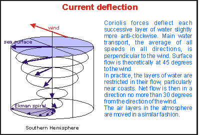 Ekman
spiral
Ekman
spiral
 The
diagram shows a cross section through a typical freshwater lake. In summer
the surface water warms up and becomes lighter than the bottom water. Although
wind-induced surface currents stir the water around, they are not strong
enough to mix the entire lake, if it is deep enough. A thermocline develops.
Had the cooler autumn not arrived, the entire lake would eventually have
warmed through by the conduction of heat downward. Organisms living above
the thermocline use up all available nutrients there, which sink to the
bottom layer with their deceased bodies. At one time, the surface water
may become very clear. By contrast, the bottom layer may become anoxic
(lacking oxygen) because oxygen is used for breaking down the dead organisms
and returning their body salts to the water as soluble nutrients.
The
diagram shows a cross section through a typical freshwater lake. In summer
the surface water warms up and becomes lighter than the bottom water. Although
wind-induced surface currents stir the water around, they are not strong
enough to mix the entire lake, if it is deep enough. A thermocline develops.
Had the cooler autumn not arrived, the entire lake would eventually have
warmed through by the conduction of heat downward. Organisms living above
the thermocline use up all available nutrients there, which sink to the
bottom layer with their deceased bodies. At one time, the surface water
may become very clear. By contrast, the bottom layer may become anoxic
(lacking oxygen) because oxygen is used for breaking down the dead organisms
and returning their body salts to the water as soluble nutrients.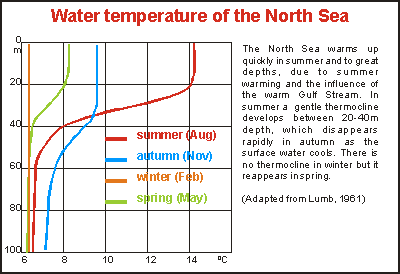 The
way things happen in the oceans is much more complicated, partly because
of the different properties of salt water (See
The
way things happen in the oceans is much more complicated, partly because
of the different properties of salt water (See 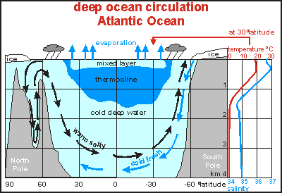 The
deep ocean circulation, which is still being studied extensively, has yielded
an amazing complexity as shown in this diagram, a cross section through
the Atlantic Ocean from the North Pole to the south Pole (90 to -90 degrees
latitude), with the equator in the middle. The curves on the right show
decreasing temperature and salinity with depth. Unlike atmospheric circulation
where warm air rises at the tropics, forming Hadley Cells and Trade Winds,
ocean water is reluctant to do the same. It is incompressible and doesn't
have its water content change from gas to water to ice and back, all major
factors in atmospheric circulation.
The
deep ocean circulation, which is still being studied extensively, has yielded
an amazing complexity as shown in this diagram, a cross section through
the Atlantic Ocean from the North Pole to the south Pole (90 to -90 degrees
latitude), with the equator in the middle. The curves on the right show
decreasing temperature and salinity with depth. Unlike atmospheric circulation
where warm air rises at the tropics, forming Hadley Cells and Trade Winds,
ocean water is reluctant to do the same. It is incompressible and doesn't
have its water content change from gas to water to ice and back, all major
factors in atmospheric circulation.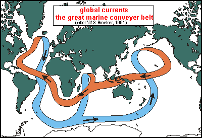 Somehow
the deep circulation and surface circulations must join up, a puzzle that
plagued scientists for many years, leading to several hypotheses. The map
here shows how the great marine conveyor belt is thought to work now. The
orange part is the surface component, which fits into the surface currents
shown above. Only in one place does the surface component dip down into
the cold depths of the deep sea: south of Greenland, as also shown in the
deep sea circulation diagram above. The cold bottom water then flows above
the ocean floor to antarctica, where some of it surfaces (not shown), but
most of the cold, nutrient-rich water will surface in two places: in the
northern Indian Ocean and northern Pacific Ocean. Although this ocean conveyor
belt moves slowly, it is massive, and plays a major role in the heat transfer
of the planet. It certainly plays a major role in the circulation of nutrients
from the depths of the oceans, back to the surface. It is speculated, that
during ice ages, the belt is interrupted over Indonesia, due to ocean levels
dipping more than 100 metres.
Somehow
the deep circulation and surface circulations must join up, a puzzle that
plagued scientists for many years, leading to several hypotheses. The map
here shows how the great marine conveyor belt is thought to work now. The
orange part is the surface component, which fits into the surface currents
shown above. Only in one place does the surface component dip down into
the cold depths of the deep sea: south of Greenland, as also shown in the
deep sea circulation diagram above. The cold bottom water then flows above
the ocean floor to antarctica, where some of it surfaces (not shown), but
most of the cold, nutrient-rich water will surface in two places: in the
northern Indian Ocean and northern Pacific Ocean. Although this ocean conveyor
belt moves slowly, it is massive, and plays a major role in the heat transfer
of the planet. It certainly plays a major role in the circulation of nutrients
from the depths of the oceans, back to the surface. It is speculated, that
during ice ages, the belt is interrupted over Indonesia, due to ocean levels
dipping more than 100 metres.