By Dr J Floor Anthoni (2000)
www.seafriends.org.nz/enviro/soil/geosoil.htm
Although soil seems the end product from weathering
rocks, it is merely a stage in the gigantic cycle of mineral recycling
by the movement of tectonic plates. Humans use soil for their daily needs
but do not sufficiently take account of its slow formation and fast loss.
Discover the amazing geology of soil formation and the basic rock and soil
types. How is soil formed? How does soil become fertile? What is the soil
cycle? How does rainfall and evaporation affect soil and the environment?
What are soil orders?
The tectonic movement of the crustal plates sweeps sediments onto continents
and underneath them where they are molten into new rock. It is a continuous
process of rejuvenating continental rock.
In the cauldron of Earth, new rocks are formed, to emerge through volcanoes
or by being exposed after erosion. The melting pot brings minerals together,
then separates them into various classes of igneous rock.
Rainfall and evaporation are essential to soil fertility and productivity,
but also to their sensitivity to erosion. Ideally, rainfall should just
exceed evaporation, but large areas of the world do not share these favourable
conditions.
related chapters
Table of rock types and gems, soils,
soil orders, soil chemistry
Begin at the beginning, the index to
soil science: ecology, sustainability, fertility, erosion, conservation,
threats, etc.
-- home -- soil
index -- Rev 20001205,20010411,20051121,20070718,
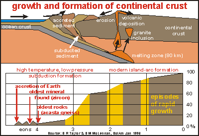
Tectonic mixing In
the section oceanography/tectonic
plates, the drifting of the continents and the formation of continental
crust is dealt with in more detail. This diagram is part of that chapter.
It shows the formation of continental crust over eons of time (billions
of years), first fast, then successively more slowly (bottom chart). The
top shows a cross-section through the earth's crust where ocean plate meets
continent. As the plate is subducted underneath the lighter continent,
it sweeps ocean and continental sediment onto the continent and also drags
it down into the hot, plastic zone. Under high pressure and heat, and under
the little understood 'ignition' of water, the sediment melts furiously,
bubbling its way up through the continent. Particularly at its margins
where the continental crust is thinnest, volcanoes are formed and hot lava
deposited on the land. Ashes are spread far afield during the initial violent
phases of volcanoes. Gases enter the atmosphere, only to be rained down
onto sea and continent.
The rock formation process shown in the top diagram is both one of mixing
and one of seggregation. On the land, rocks weather and form soil. Both
are eroded, transported by running water and deposited, always down-hill
until they end up in the sea. Nutrients and other dissolved chemicals,
are transported into the sea and used by plankton organisms who die and
rain down onto the ocean bottom, complete with their cargo in minerals
(body and shell). Winds blow over the land, blowing fine dust far out into
the ocean. But eventually, it all gets swept 'under the carpet' to be molten
together in the cauldron of the magma chamber, discussed in the next chapter.
Rock formation As the molten magma bubbles up from the subduction zone through the
continental crust, it forms chambers (see cross-section above) with molten
magma, which cools slowly. In the process, elements (of which minerals
are made) separate out in zones. Heavy elements sink to the bottom while
lighter elements float to the top, and gases rise there too. In their own
zones, the elements combine to form minerals. Minerals are crystallised
combinations of elements, often allowing a number of different compositions,
which makes an enormous variability in the end result. By the process of
'liquid solution', minerals seggregate out in predictable ways and sequences.
This is explained in more detail in the rock
classification table.
Molten
magma may push itself out through the surface, forming volcanoes in the
process. In its early years, a volcano belches light materials and gases
under enormous pressure. Such volcanoes are 'rhyolitic' (Mt St Helens),
belching dust and ash high up in the atmosphere. As the pressure in the
magma chamber underneath the volcano diminishes, the volcano also calms
down, eventually oozing liquid lava with ever higher density, until the
pressure is insufficient to bring up any more material. The magma chamber
cools off slowly and the volcano dies. Sometimes the magma chamber can't
reach the surface, solidifying slowly inside the earth with all its treasures
locked inside. In the process, minerals have the time to form beautiful
and large crystals. The rock thus formed, shows these clearly (granite,
gabbro, peridotite, precious stones).
In the diagram one can see the various kinds of igneous (from molten
magma) rock and how they relate. Inside the diagram the various minerals
(quartz, feldspar and so on) are mentioned and their ratios in the rock
formed from it. From top left to bottom right, one can imagine the cross-section
through a magma chamber, the lighter elements on top (quartz), heavier
ones below (olivine). In this direction, also the density of the rock (specific
mass, relative to water), changes from 2.4 for quartz to over 3.4 for olivine.
The heaviest materials, sinking to the bottom of the cauldron, are the
metal ores, not shown in the diagram.
Rocks formed outside the crust, and cooling rapidly, are called extrusive,
whereas those formed inside by slow cooling, intrusive. The extrusive series
from left to right names the kinds of rock emanating from volcanoes, as
these age (rock also becomes denser). First rhyolite (frothy rock, ash)
then dacite (in between), andesite (solid lava) and basalt (the crater
plug). The intrusive series starts with light granite and ends with heavy
peridotite. For more details, see the rock classification
table.
Where do the minerals that are important for life end up? In the cauldron,
they are seggregated by mass. Imagine the main substance in the cauldron
is quartz SiO2 or related silicates. From the periodic
table of elements, the atomic masses can be found: O=16, Si=28. The
main nutrients are: N=14, Mg=24, P=30, S=32, K=39, Ca=40. Mg and Ca are
found in amphibole, pyroxene, olivine, feldspars. Potash (K) in potash
feldspars. Phosphorus (P), sulphur (S) and nitrogen (N) are not well
represented in these rocks.
What is important to remember is that, starting from a well mixed cauldron
with sediments, the formed rocks end up with different properties, and
thus the soils formed from them. This is the first step in the seggregation
of minerals. Sedimentation and sediment transport is another one. But let's
first turn to the process of soil formation.
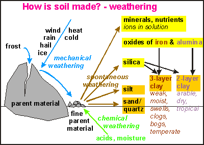
Soil formation One
of the most important scientific discoveries was how soil forms spontaneously
from rock. Under the influence of physical factors like deformation by
heat and cold, assault by wind, rain, hail and ice, and the enormous levering
forces of water expanding into ice, solid rock is shattered into smaller
pieces (see picture). But however small these fragments, they still have
the same properties as the parent rock.
Being formed under high pressure and temperatures, the crystals of
the minerals in the rock are somewhat unstable at surface pressure and
temperature. Particularly when attacked by acids that etch away the soluble
components in the minerals, the crystals fall apart, albeit very slowly.
It is called spontaneous weathering, but it is accelerated considerably
under the influence of vegetation and its acids (chemical weathering).
During the weathering process, four
components are released:
minerals in solution (cations and anions), the basis of plant nutrition.
oxides of iron and alumina (sesquioxides Al2O3, Fe2O3).
various forms of silica (silicon-oxide compounds).
stable wastes as very fine silt (mostly fine quartz) and coarser quartz
(sand). These have no nutritious value for plants.
Factors in soil formation:
parent material
time
climate
atmospheric composition
topography
organisms
Depending on temperature and rainfall, new minerals are formed. The
oxides of iron and alumina combine with silica to form clay. In temperate
regions a three-layer clay is formed, which is weak, swells under moisture,
and clogs. It is able to absorb large amounts of water but is rather heavy
on plant roots, blocking the oxygen the soil organisms need. Because clay
has a charged surface area, it is able to bind and retain minerals and
nutrients (Cation Exchange Capacity). The valuable nutrition for plants
won't leach away easily in three-layer clays.
Two-layer clays are formed in hot, humid tropical regions, producing
arable but easily dried soils. These clays are not able to hold much water,
or nutrients, but are still very much better than sand.
Soil's
productivity is mainly due to the clays in the soils. Knowing that clay
particles are very small (less than 2 microns), one can imagine that this
component is easily eroded out of the soil. Its small size prevents it
from sedimenting out rapidly in water, resulting in rivers, lakes and ocean
water staying turbid for a long time after rains have ended.
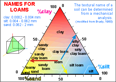
The mix of sand, silt and clay is called a loam. In this diagram, the
triangle represents all possible combinations of the three. Soil specialists
use names for the various loams, as indicated in the diagram. A loam can
be dried and pounded in the laboratory and passed through sieves to separate
the mix by particle size. From the diagram, the official composition of
'loam' can be inferred - sand:silt:clay = 40:40:20. (Draw lines parallel
to each side and read the left-hand values.)
Sand is very workable but won't hold water, or nutrients well. Loam
is poor in nutrients, reasonably workable, but holds water well. Clay is
difficult to work, compacts easily, but holds water and nutrients well,
but is reluctant to release these to plants. As the diagram shows, the
various loams derived from the three base components, have varying workability,
water holding capacity and cation exchange capacity (CEC).
Not only temperature and moisture affect soil formation but also the
level of the groundwater table and the steepness and elevation. As can
be seen, soil formation depends on many factors, regional and local, resulting
in an almost infinite number of different soils, each having different
needs. Nutrients therefore, can vary considerably from patch to patch,
requiring careful application and observation.
Soil profile Whereas
soil is formed from the rock below, it is eroded away from the top. A cover
of plant life slows down erosion, allowing the soil layer to build up,
but there is more going on.
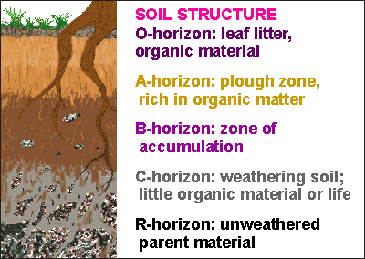
Just above the base rock, is the C-horizon, containing the recently
weathered and still weathering soil. It is rich in nutrients. The A-horizon
is where most plant roots are found and all soil organisms. Its nutrients
have been used by plants or leached downward, so it is relatively poor
in nutrients, but rich in life. By comparison, the B-horizon is the zone
where new material from below and nutrients from above accumulate. Sometimes
an impermeable layer or pan is formed above it (podsol), denying plants
to access this rejuvenating source of new nutrients. On the surface of
the soil, often a thin layer is found, rich in leaf litter and other organic
material.
horizon
description of detailed
soil horizons
O
consists mainly of organic
matter from the vegetation, which accumulates under conditions of free
aeration.
A
eluvial (outwash) horizon
consisting mainly of mineral matter mixed with some humified (decomposed)
organic matter.
E
strongly eluviated horizons
having much less organic matter and/or iron and/or clay than the horizons
underneath. Usually pale coloured and high in quartz.
B
illuvial (inwashed) horizon
characterised by concentrations in clay, iron or organic matter. Some lime
may accumulate, but if the accumulation is excessive, the horizon is named
K.
K
horizon containing appreciable
carbonate, usually mainly lime or calcium carbonate.
G
gleyed horizons which form
under reducing (anoxic) conditions with impeded aeration, reflected in
blueish, greenish or greyish colour.
C
weathered parent material
lacking the properties of the solum and resembling more the fresh parent
material.
R
regolith, the unconsolidated
bedrock or parent material.
Soil and top soil are produced naturally at a rate of 1mm in 200-400
years, averaging at about 1 ton/ha/y. A full soil profile develops in 2,000
- 10,000 years, a period which is long for humans but short for the planet.
World-wide, agricultural soil is lost at a rate 10-40 times faster than
its natural replacement. The USA lost 80mm since farming began, 200 years
ago. This amounts to some 18 t/ha/y. China appears to lose 40 t/ha/y. World-wide
loss of agricultural land is 6 million ha per year, from a world-wide total
of 1200 million ha (0.5%/y). These are compelling reasons for improving
the way humans manage their soils.
Sediments Soil
erosion is a natural process, part of the gigantic cycles of minerals.
As the soil erodes, its particles are transported down-hill towards ever
faster flowing rivers, which eventually slow down in their lower reaches.
As the water slows down, first the coarse material settles, the cobbles,
shingle and gravel. Then sand, silt and finally mud. In the flood
plains of a river, silt and sand are deposited with some mud, creating
some of the most fertile and workable soils of the world. In estuaries,
under the influence of tides and waves, fine particles are washed out and
sand flats are left behind. When the sea level drops, these become workable
soils but poor in nutrients.
In the sea, something similar happens. Close to shore the coarser particles
accumulate, whereas the finest particles settle out furthest away. As thick
layers are formed, water is squeezed out and the sediment compacted to
form new rocks, sedimentary rocks. These may be pushed up by tectonic upheaval,
creating new bedrock, becoming weathered and forming soil and so on. Sedimentary
rocks are: conglomerate, sandstone, mudstone, and limestone.
When subjected to extreme pressure, by being pushed deep down, or by
colliding forces, sedimental rock will metamorphose into new, harder rock
forms like gneiss, schist, greywacke and marble. These weather like the
original igneous rocks, to form sand, silt and clay.
We've now come full circle in our description of the rock/soil/mineral
cycle.
Soil orders The
main soil orders of the world follow the main terrestrial habitats because
they depend on the same conditions of temperature and humidity. Please
refer to the section oceanography/currents
to study how climate comes about and where rain falls.
This diagram illustrates the principles behind the various soil orders
in a north-south (left-right) soil cross-section from tundra to desert.
The top part shows three graphs of temperature, rainfall and evaporation.
Potential evaporation is a property of soil that can entirely be predicted
from temperature. As the temperature increases, water molecules become
more volatile, resulting in a predictable potential loss (potential evaporation).
The difference between rainfall and evaporation is what remains for the
vegetation. Large areas of the world have at least one season where this
is the case. Only few places have rain in all seasons; New Zealand being
one of these.
Tundra is a vegetation of mosses and lichens, only just capable
of growing in the short season of light and thaw. Their soils are boggy,
never able to thaw completely, and the groundwater table is permanently
frozen (permafrost). As rainfall and evaporation increase, soils can develop
further south of this region.
The taiga conifer forest is only just able to grow in the cold
summers. With rainfall exceeding evaporation, and soils acidified by the
trees' resins, nutrients and clays are leached downward, forming grey podsols
where most clay is found in the B horizon, leaving the A horizon sandy.
Deeper soils are formed in the mid-latitudinal areas, the temperate
zone, where evaporation roughly equals rainfall. Deciduous forests
can now grow in the long summer months, hybernating in winter. Under these
conditions, productive grey/brown soils are formed.
As the water table descends further, soils deepen, while warm, dry conditions
are favourable for savannah and prairies. Populated by deep-rooting
grasses that produce just enough aciditiy to retain clay but not enough
to leach its nutrients. Under these conditions, fertile black chernozem
soils are formed, rich in humus.
As the water table descends further, and evaporation far exceeds rainfall,
soils become chestnut/cinnamon coloured and unproductive. The steppe
grasslands, Mediterranean scrub and Californian chaparral are only
a step away from the desert. Seasonally, these soils dry so thoroughly
that instead of clays, oxides of iron are formed. These cinnamon-coloured
soils contain very little clay and are very poor in humus and organic material.
Desert soils are characterised by severe erosion and slow weathering.
They are very poor and easily disturbed by wind and occasional rain. Horizons
of calcium-bearing deposits form, like gypsum.
Not shown in the picture are the rain forest soils. Because of
extensive rainfall, the water table extends almost to the surface, for
most of the year. Deep soils cannot develop and all minerals and nutrients
are stored in the vegetation above and in a rich, deep organic O-horizon.
Trees can grow only if some other tree sheds a leaf that becomes decomposed,
or if an animal dies and decomposes. Although such ecosystems look very
rich, they are not productive and are unsuitable for human exploitation.
Evaporation and rainfall In the diagram of the previous chapter, a soil and vegetation profile
was followed that ran across the most fertile regions of the USSR. with
rainfall just exceeding evaporation. Very fertile black-earth regions developed,
very suitable for cropping. But large areas of the world do not enjoy such
balanced situations. In this chapter we'll explore how rainfall and the
sun's radiation, which causes evaporation, relate.
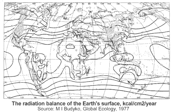
If
evaporation exceeds rainfall, soils become arid. If rainfall exceeds loss,
soils become boggy. In either case, productivity is reduced considerably.
Where rainfall exceeds twice the potential evaporation, as is found in
some tropical rainforests, the ecosystem won't sustain exploitation by
humans. Likewise the soils where evaporation exceeds rainfall by a factor
of two, the deserts and dry soils. These soils should either be left alone,
never to be exploited by modern farming, or be farmed with utmost care.
This map shows the areas that are either too dry or too wet. Note that
human technology cannot improve their sustainably.
When all other areas that are not suitable for agriculture are added:
the mountains, the ice-cover, the tundra and even a large part of the taiga
(boreal forests), very little suitable land area remains.
For maps of the original vegetation of the world, visit oceans/productivity.
In
the early seventies, advanced climatological and ecological work was done
by the Russian scientist Mikhail Ivanovich Budyko, who developed and proved
advanced ecological theories. Budyko observed that the heat balance of
the Earth's surface drives many of its phenomena, like the weather. This
heat or radiation balance at the Earth's surface, can be defined as:
radiation balance = solar radiation - heat to atmosphere - heat to
soil/sea - horizontal heat transport
Heat loss due to horizontal transport of water, cancels out on average
(but not everywhere), and the heat loss in warming the soil is very small,
so the radiation balance is the amount of solar heat left over to do work,
like changing the status quo; warming the soil, evaporating moisture and
so on. Budyko measured the radiation balance to make the map shown below.
Runoff, the flow of water over the land into rivers and the sea, is
basically:
runoff = rainfall - evaporation - drainage through the soil.
As drainage through the soil is small, runoff depends mainly on water
that did not evaporate. Local conditions affect runoff, like soil porosity,
soil depth and the amount of water transpired by plants. The latter requires
the same heat as evaporation, and can thus be included in evaporation.
Soils may be porous, but eventually they will saturate. Soil porosity is
important to be able to soak large rains before these cause damaging runoff
and to store moisture in between rains, but eventually the soil will saturate.
Note that the fanning curves all have a horizontal bit starting from the
bottom left corner. As rainfall increases, runoff won't occur until the
point of soil saturation is reached. From there on runoff increases rapidly,
but not as rapidly as the first curve for which evaporation is zero and
runoff is 100% of rainfall. In winter, rainfall is high and the radiation
balance is low, resulting in high runoff, whereas in summer the opposite
is true. The theory should thus be interpreted with care.
The curves in the diagram (radiation balance from 0 to 70) cover most
areas of the world, as shown in the map below. It can be seen that runoff
of 0.5m/yr is easily exceeded. If runoff is to stay below 25% of rainfall
(the green line), sustainable farming is achievable only with rainfall
in between 0.4 and 1.0 m/yr. In New Zealand, where the radiation balance
is between 50 and 70, sustainable farming can be achieved in areas with
rainfall between 0.7 and 1.0 m/yr. Notice that some runoff is needed to
eluviate (wash out) excess salts from the soil. As can be seen, sustainable
farming is difficult to achieve, but more about this in the chapters on
erosion and sustainability.
The water balance for land surfaces and
the oceans quantifies the water cycle:
precipitation = evaporation + runoff + drainage
Drainage into the soil changes water levels of aquifers and does not
contribute largely to the horizontal water displacement caused by runoff
through rivers, so it can be ignored. The table shows actual values for
all continents and oceans. Note that for the oceans the equation becomes:
excess = precipitation + runoff - evaporation
Note that the Atlantic has a shortage of 12 cm/yr, meaning that it is
losing water to evaporation and that it continually borrows water from
other oceans. Likewise the Pacific has an excess of 3 cm/yr. Note that
total runoff from the land appears different from total runoff into oceans,
because the surface of the oceans is much larger, and Antarctica and the
Southern Ocean are missing.
water balance on
continents and oceans
continent/ ocean
rain/snow cm/year
evapo cm/yr
run-off cm/yr
runoff% /excess
Europe
Asia
Africa
N America
S America
Australia
All land
 In
the section oceanography/tectonic
plates, the drifting of the continents and the formation of continental
crust is dealt with in more detail. This diagram is part of that chapter.
It shows the formation of continental crust over eons of time (billions
of years), first fast, then successively more slowly (bottom chart). The
top shows a cross-section through the earth's crust where ocean plate meets
continent. As the plate is subducted underneath the lighter continent,
it sweeps ocean and continental sediment onto the continent and also drags
it down into the hot, plastic zone. Under high pressure and heat, and under
the little understood 'ignition' of water, the sediment melts furiously,
bubbling its way up through the continent. Particularly at its margins
where the continental crust is thinnest, volcanoes are formed and hot lava
deposited on the land. Ashes are spread far afield during the initial violent
phases of volcanoes. Gases enter the atmosphere, only to be rained down
onto sea and continent.
In
the section oceanography/tectonic
plates, the drifting of the continents and the formation of continental
crust is dealt with in more detail. This diagram is part of that chapter.
It shows the formation of continental crust over eons of time (billions
of years), first fast, then successively more slowly (bottom chart). The
top shows a cross-section through the earth's crust where ocean plate meets
continent. As the plate is subducted underneath the lighter continent,
it sweeps ocean and continental sediment onto the continent and also drags
it down into the hot, plastic zone. Under high pressure and heat, and under
the little understood 'ignition' of water, the sediment melts furiously,
bubbling its way up through the continent. Particularly at its margins
where the continental crust is thinnest, volcanoes are formed and hot lava
deposited on the land. Ashes are spread far afield during the initial violent
phases of volcanoes. Gases enter the atmosphere, only to be rained down
onto sea and continent.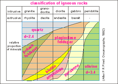 Molten
magma may push itself out through the surface, forming volcanoes in the
process. In its early years, a volcano belches light materials and gases
under enormous pressure. Such volcanoes are 'rhyolitic' (Mt St Helens),
belching dust and ash high up in the atmosphere. As the pressure in the
magma chamber underneath the volcano diminishes, the volcano also calms
down, eventually oozing liquid lava with ever higher density, until the
pressure is insufficient to bring up any more material. The magma chamber
cools off slowly and the volcano dies. Sometimes the magma chamber can't
reach the surface, solidifying slowly inside the earth with all its treasures
locked inside. In the process, minerals have the time to form beautiful
and large crystals. The rock thus formed, shows these clearly (granite,
gabbro, peridotite, precious stones).
Molten
magma may push itself out through the surface, forming volcanoes in the
process. In its early years, a volcano belches light materials and gases
under enormous pressure. Such volcanoes are 'rhyolitic' (Mt St Helens),
belching dust and ash high up in the atmosphere. As the pressure in the
magma chamber underneath the volcano diminishes, the volcano also calms
down, eventually oozing liquid lava with ever higher density, until the
pressure is insufficient to bring up any more material. The magma chamber
cools off slowly and the volcano dies. Sometimes the magma chamber can't
reach the surface, solidifying slowly inside the earth with all its treasures
locked inside. In the process, minerals have the time to form beautiful
and large crystals. The rock thus formed, shows these clearly (granite,
gabbro, peridotite, precious stones).
 One
of the most important scientific discoveries was how soil forms spontaneously
from rock. Under the influence of physical factors like deformation by
heat and cold, assault by wind, rain, hail and ice, and the enormous levering
forces of water expanding into ice, solid rock is shattered into smaller
pieces (see picture). But however small these fragments, they still have
the same properties as the parent rock.
One
of the most important scientific discoveries was how soil forms spontaneously
from rock. Under the influence of physical factors like deformation by
heat and cold, assault by wind, rain, hail and ice, and the enormous levering
forces of water expanding into ice, solid rock is shattered into smaller
pieces (see picture). But however small these fragments, they still have
the same properties as the parent rock.
 Soil's
productivity is mainly due to the clays in the soils. Knowing that clay
particles are very small (less than 2 microns), one can imagine that this
component is easily eroded out of the soil. Its small size prevents it
from sedimenting out rapidly in water, resulting in rivers, lakes and ocean
water staying turbid for a long time after rains have ended.
Soil's
productivity is mainly due to the clays in the soils. Knowing that clay
particles are very small (less than 2 microns), one can imagine that this
component is easily eroded out of the soil. Its small size prevents it
from sedimenting out rapidly in water, resulting in rivers, lakes and ocean
water staying turbid for a long time after rains have ended.
 Whereas
soil is formed from the rock below, it is eroded away from the top. A cover
of plant life slows down erosion, allowing the soil layer to build up,
but there is more going on.
Whereas
soil is formed from the rock below, it is eroded away from the top. A cover
of plant life slows down erosion, allowing the soil layer to build up,
but there is more going on.
 Soil
erosion is a natural process, part of the gigantic cycles of minerals.
As the soil erodes, its particles are transported down-hill towards ever
faster flowing rivers, which eventually slow down in their lower reaches.
As the water slows down, first the coarse material settles, the cobbles,
shingle and gravel. Then sand, silt and finally mud. In the flood
plains of a river, silt and sand are deposited with some mud, creating
some of the most fertile and workable soils of the world. In estuaries,
under the influence of tides and waves, fine particles are washed out and
sand flats are left behind. When the sea level drops, these become workable
soils but poor in nutrients.
Soil
erosion is a natural process, part of the gigantic cycles of minerals.
As the soil erodes, its particles are transported down-hill towards ever
faster flowing rivers, which eventually slow down in their lower reaches.
As the water slows down, first the coarse material settles, the cobbles,
shingle and gravel. Then sand, silt and finally mud. In the flood
plains of a river, silt and sand are deposited with some mud, creating
some of the most fertile and workable soils of the world. In estuaries,
under the influence of tides and waves, fine particles are washed out and
sand flats are left behind. When the sea level drops, these become workable
soils but poor in nutrients.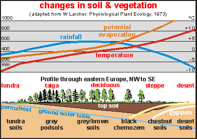 The
main soil orders of the world follow the main terrestrial habitats because
they depend on the same conditions of temperature and humidity. Please
refer to the section
The
main soil orders of the world follow the main terrestrial habitats because
they depend on the same conditions of temperature and humidity. Please
refer to the section 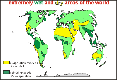 If
evaporation exceeds rainfall, soils become arid. If rainfall exceeds loss,
soils become boggy. In either case, productivity is reduced considerably.
Where rainfall exceeds twice the potential evaporation, as is found in
some tropical rainforests, the ecosystem won't sustain exploitation by
humans. Likewise the soils where evaporation exceeds rainfall by a factor
of two, the deserts and dry soils. These soils should either be left alone,
never to be exploited by modern farming, or be farmed with utmost care.
This map shows the areas that are either too dry or too wet. Note that
human technology cannot improve their sustainably.
If
evaporation exceeds rainfall, soils become arid. If rainfall exceeds loss,
soils become boggy. In either case, productivity is reduced considerably.
Where rainfall exceeds twice the potential evaporation, as is found in
some tropical rainforests, the ecosystem won't sustain exploitation by
humans. Likewise the soils where evaporation exceeds rainfall by a factor
of two, the deserts and dry soils. These soils should either be left alone,
never to be exploited by modern farming, or be farmed with utmost care.
This map shows the areas that are either too dry or too wet. Note that
human technology cannot improve their sustainably. In
the early seventies, advanced climatological and ecological work was done
by the Russian scientist Mikhail Ivanovich Budyko, who developed and proved
advanced ecological theories. Budyko observed that the heat balance of
the Earth's surface drives many of its phenomena, like the weather. This
heat or radiation balance at the Earth's surface, can be defined as:
In
the early seventies, advanced climatological and ecological work was done
by the Russian scientist Mikhail Ivanovich Budyko, who developed and proved
advanced ecological theories. Budyko observed that the heat balance of
the Earth's surface drives many of its phenomena, like the weather. This
heat or radiation balance at the Earth's surface, can be defined as: