 Interestingly,
picture D shows what happened to our hard sea coasts, where mountain ridges
border the sea. Remember those mysterious rock platforms extending out
in sea, just above low tide level? They show us where the coast was 65,000
years ago (and 100,000 years ago), before the last ice age, and 4000 years
ago, when the oceans slowed their rapid rise. The distance between the
edge of these platforms and the current cliff faces represents some 4000
years of coastal erosion. The reason that the platforms are so resilient
against erosion by the sea, is probably because they are covered with a
protecting film of life. This film of life consists mainly of algae, and
in particular the stone-leaf coralline alga Lithothamnion, need
to be covered in water, and need sunlight as well. This also explains why
their level is just above low tide, even though erosive forces there are
strongest. Interestingly,
picture D shows what happened to our hard sea coasts, where mountain ridges
border the sea. Remember those mysterious rock platforms extending out
in sea, just above low tide level? They show us where the coast was 65,000
years ago (and 100,000 years ago), before the last ice age, and 4000 years
ago, when the oceans slowed their rapid rise. The distance between the
edge of these platforms and the current cliff faces represents some 4000
years of coastal erosion. The reason that the platforms are so resilient
against erosion by the sea, is probably because they are covered with a
protecting film of life. This film of life consists mainly of algae, and
in particular the stone-leaf coralline alga Lithothamnion, need
to be covered in water, and need sunlight as well. This also explains why
their level is just above low tide, even though erosive forces there are
strongest. |
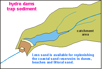 An
argument often touted to explain why beaches are disappearing, is that
of the large and increasing number of dams in rivers for energy generation,
irrigation and flood control. They trap up-river sediment and indeed reduce
the amount of sand that could otherwise have reached the sea. In some major
rivers such as the Nile, this has affected the sediment budget considerably
but overall, their influence is rather small. Every year more and more
forests are burnt to make room for agriculture, a practice that increases
soil erosion and hence the quantity of new sand, enormously. Here in New
Zealand, the loss of sand from hydro dams is negligible.
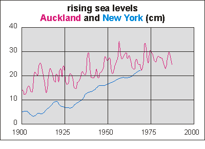 As
a consequence of global climate warming, it has been predicted that sea
levels would rise, on the one hand by the sea water column expanding and
on the other by the melting water from glaciers and polar ice caps.
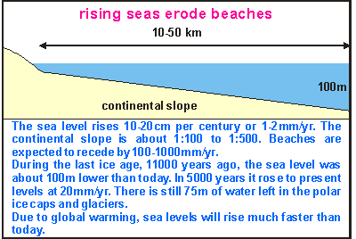 Much
scientific work has been done to correlate the world wide beach erosion
with rising sea levels. The argument is shown in this diagram of the continental
shelf.
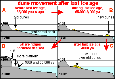 Before the last ice age, about 65000 years ago, the sea stood almost exactly
where it is found today, evident from the location of old (pleistocene)
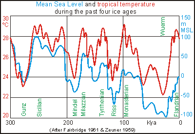
dune sands (picture A). During the last glaciation (ice age), the ocean's
level sank by about 120m because of the amount of water locked up in ice
caps and glaciers. As the seashore moved outward toward the edge of the
continental shelf (but not quite), the old sand was left behind, but new
dunes and beaches formed (picture B). By about 6000 years ago, the oceans
started to rise again, sweeping the new sand dunes before it while destroying
the coastal vegetation, all the way from the shelf edge to where they are
found today, overlaying the old dune sand (Picture C). The rapid rise in
sea level ended some 4000 years ago.
 As
the seas are slowly rising further, these new dunes will just shift slowly
further inland, but remember that they have been where they are today for
some 4000 years! However, what we are experiencing today is that the dune
sand is moving seaward as the sea is moving landward, something quite contrary
to what has been happening in the past 6000 years! Obviously, we have to
find better answers to why many beaches are eroding so rapidly today, and
why at the same time, some beaches are not eroding at all..
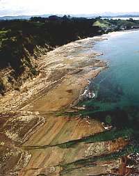
 Interestingly,
picture D shows what happened to our hard sea coasts, where mountain ridges
border the sea. Remember those mysterious rock platforms extending out
in sea, just above low tide level? They show us where the coast was 65,000
years ago (and 100,000 years ago), before the last ice age, and 4000 years
ago, when the oceans slowed their rapid rise. The distance between the
edge of these platforms and the current cliff faces represents some 4000
years of coastal erosion. The reason that the platforms are so resilient
against erosion by the sea, is probably because they are covered with a
protecting film of life. This film of life consists mainly of algae, and
in particular the stone-leaf coralline alga Lithothamnion, need
to be covered in water, and need sunlight as well. This also explains why
their level is just above low tide, even though erosive forces there are
strongest.