|
Where
|
Description
|
Year [1] |
km2[2] |
Q[3] |
|
|
Kermadec Islands marine
reserve. Subtropical rocky shore, oasis, surrounded by a large 'empty'
ocean. A large section has been devoted to this jewel in the crown of NZ's
marine reserves (~80 pages). |
1990,DoC |
7480
|
5 |
|
North Cape
|
North Cape (Piwhane-Spirits
Bay) no-fishing zone to protect the benthic fauna to 50m deep. No coast;
sandy bottom with rock flats in very strong currents and turbulence. |
1999,MfE |
1059
|
4 |
|
|
The wreck of the Rainbow
Warrior is a voluntary marine reserve. Sheltered wreck. |
1987, Vol |
0.01
|
4 |
|
Mimiwhangata
|
The Mimiwhangata Marine
Park. Exposed rocky shore promontory. See new proposal. |
1983,MoF |
20 |
3 |
|
|
The Poor Knights Islands
marine reserve. Rocky shore, oasis, islands. |
1981,DoC |
24.1
|
3-4 |
|
|
The Cape Rodney to Okakari
Point marine reserve. Goat Island. Exposed rocky shore with shelter
and caves. |
1975,DoC |
5.2
|
3 |
|
Tawharanui
|
The Tawharanui Marine Park.
Exposed rocky shore promontory. No shelter, no caves, shallow sand. Proposed
status change. |
1981,MoF |
3.5 |
3 |
|
Long Bay
|
Long Bay marine reserve,
North Auckland. Sheltered rocky shore, estuary and beach. |
1997,DoC |
9.8
|
1-2 |
|
|
A sheltered harbour at the
south-eastern end of Waiheke Island, near Auckland. Sheltered inlet, muddy-sandy
bottom. |
2003,DoC |
7.0?
9.0?
|
1-2 |
|
Pollen Island
|
Pollen Island (Motu Manawa)
marine reserve, West Auckland. Estuarine mudflats. |
1997,DoC |
5.0
|
- |
|
Hahei
|
Whanganui A Hei marine reserve.
(Cathedral Cove). Exposed to semi exposed rocky shore, small beach. |
1992,DoC |
8.4
|
4 |
|
Mayor Island
|
Tuhua marine reserve (Mayor
Island). Exposed rocky shore. Small part of island. |
1992,DoC |
10.6
|
4 |
|
Te Tapuwae
|
Te Tapuwae o Rongokako (Gisborne)
Marine Reserve, 16km north of Gisborne. Exposed rocky shore. |
1999,DoC |
24.5
|
2 |
|
|
Te Angiangi marine reserve.
East coast of central Hawkes Bay near Napier. Exposed rocky shore. |
1997,DoC |
4.5
|
2 |
|
Sugarloaf
|
Sugarloaf Island Marine
Protected Area (SLIMPA) near New Plymouth. Exposed rocky pinnacles. |
1991,Own |
8.0
20.0? |
3 |
|
Kapiti
|
Kapiti Island marine reserve.
Rocky shore. Part island, part beach |
1992,DoC |
21.7
|
3-4 |
|
Taputeranga
|
The exposed rocky shore
south of Wellington: Owhiro, Island, Princess and Houghton Bays. |
2008,F&B |
8.5
|
3 |
|
Long Island
|
Long Island (Kokomohua)
marine reserve, Queen Charlotte Sound. Shelterd rocky shore and sand flats. |
1993,DoC |
6.2
|
2-3 |
|
Nelson
|
Glenduan to Ataata Point
marine Reserve. Semi-exposed rocky shore, shallow sandy/muddy bottom. |
proposed |
-
|
2 |
|
Tonga Island
|
Abel Tasman National Park.
Semi-exposed rocky shore, sandy beaches, shallow water. |
1993,DoC |
18.4
|
1-2 |
|
Westhaven
|
Westhaven (Te Tai Tapu)
marine reserve. North-west coast. Estuary. |
1994,DoC |
5.4
|
2 |
|
Kaikoura
|
The Kaikoura Marine Reserve.
Exposed rocky outcrops of the Kaikoura Peninsula |
proposed |
-
|
2-3 |
|
Banks Peninsula
|
Banks Peninsula Marine Mammals
Sanctuary. To protect Hector's Dolphins. |
|
-
|
3 |
|
Pohatu
|
Akaroa Hr, Banks Peninsula,
South Island. Exposed rocky shore, inlet. Protects nesting penguins |
1999,DoC |
2.18
|
3 |
|
Milford
Sound
|
Milford sound (Piopiotahi)
marine reserve. Sheltered deepwater fiord rocky shore. |
1993,DoC |
6.9
|
2 |
|
Fiordland
|
Fiordland fisheries management
areas with protected sites. Sheltered fiord habitat. |
2003,GoF |
?
|
- |
|
The Gut
|
Te Awaatu Channel marine
reserve (Dusky Sound). Sheltered fiord rocky shore, shallow. |
1993,DoC |
0.9
|
4 |
|
Nugget Point
|
An exposed promontory and
pinnacle group between Balclutha and the Catlins. Exposed rocky shore.
Proposed 1992. |
DoC |
6?
|
- |
|
Stewart
Island
|
Patersons Inlet |
- |
-
|
- |
|
Auckland
Island
|
Auckland Islands Marine
Mammals Sanctuary + Motu Maha marine reserve protects the entire underwater
environment down to 3000m. Part of the Subantarctic World Heritage Area. |
2003,DoC |
4840
|
- |
| |
|
|
|
|
| |
|
|
|
|
| |
Other
proposed marine reserves (see the war for marine
reserves for updated information) |
|
|
|
|
Volkner
Rocks
|
Very exposed remote pinnacle
group near White Island. |
applied |
?
|
- |
|
Tiritiri
Matangi
|
Semi-exposed island, deep
mud flats, sheltered promontory. |
proposed |
-
|
- |
|
Arid Island
|
North-East Great Barrier
Island. Exposed to semi-sheltered rocky shore, sand flats, small estuary
and beach. |
cancelled |
?
|
3 |
|
Mimiwhangata
|
Status change from Marine
Park to Marine Reserve, and extension. Exposed rocky shore with beaches
and sand flats. |
proposed |
|
- |
|
Mahurangi
|
The Mid-Gulf Marine Reserve,
around Mahurangi Harbour. Semi-exposed to sheltered rocky shore, sandy-muddy
bottom. |
proposed |
?
|
2 |
|
Whangarei
Hr
|
Two sites protecting 2.2%
of Whangarei Harbour. Sheltered sand and mudflats with current channels.
Proposed by Kamo School, accepted by DoC in Dec 2004. |
2004, DoC |
2.31
|
- |
|
Marine
reserve investigations (see the war for marine
reserves) |
|
|
|
|
Whangarei Harbour, Three
Kings Islands, Taronui Whangaroa Hr, Bay of Islands, Cape Brett, Motu Kararo
I Whangarei Heads, Auckland West Coast, Firth of Thames, Whangara, Pukerua
Bay, Pauatahanui Inlet, Parininihi, French Pass, Paparoa South I West Coast,
Moeraki West Coast, Jackson Head West Coast, Inner fiords and sounds. |
|
|
|
|
|
|
|
|
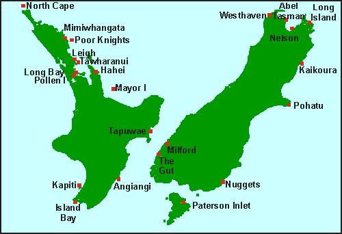
 Since
their first concept in 1975, and the establishment of the first marine
reserve at Leigh, many others followed. Some are voluntary, others managed
by the Minister of Fisheries, but most are now managed by the Department
of Conservation. In this Marine Reserves section of the Seafriends web
site, you will find detailed information of each, complete with photos
and maps, how to get there, and an assessment of the underwater environment.
For other details, visit the Department
of Conservation's web site, or its overview
map with links. On this overview map each of our marine reserves has
been indicated by a red dot and a short name, which is often not its official
name. Consult the table below for a quick overview by date of establishment,
and click on the link for more detail. The first column gives a short key
name, coresponding with the overview map. The description column gives
the reserve's full and official name and environment type. Underneath the
year of establishment, one finds an abbreviation of who manages it. Then
follows a column with the extent of the area in square kilometres (1km2=100
ha). Finally we have added a quality assessment column, which is entirely
our own. It shows the state of its marine environment. Unfortunately, many
of our marine reserves are stressed or degrading rapidly. For more on resource
management, biodiversity, principles of conservation and marine reserves,
visit our conservation section. Here you will also find more about why
reserves can fail, and how to asses marine environmental quality.
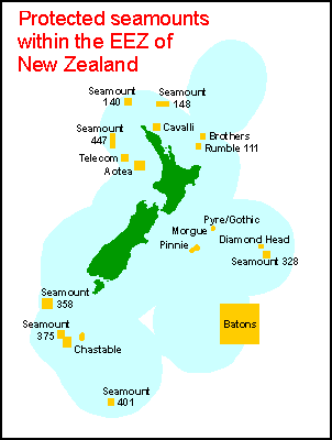
 Protected
seamounts