|
by Dr J Floor Anthoni www.seafriends.org.nz/indepth/cyclone_heta.htm |
 |
 |
|
by Dr J Floor Anthoni www.seafriends.org.nz/indepth/cyclone_heta.htm |
 |
 |
|
|
|
.
 Situation Situation
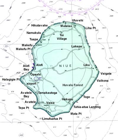
Niue is a small independent state on top of a large sleeping volcano rising steeply from a 3000-4000m deep ocean. Located between Tonga on the west and the Cook Islands further east, it marks the boundary of the paths taken by large tropical cyclones, which are born above warm tropical seas. Niue is only a small limestone island, measuring about 23 by 18 km with a total surface area of 250km2. It rises to only 68m above sea level, with most of the island no higher than 30m. Its population is estimated at 1400-1800, with around 200-300 tourists enjoying the clear waters, caves and calving humpback whales in winter (Aug-Oct). However, most of the 20,000 Niueans live in Auckland, New Zealand and another 2000 in Australia. Located 19 degrees south of the Equator, Niue experiences regular trade winds from the south-east, which renders the coast of this part of the island inhospitable. Understandably, the NW side of the island is more sheltered, reason why most of its population and tourist activities reside here, and goods are landed here by ship. But this is also the side facing the path of cyclones and their most vicious winds. |
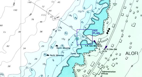 [1] The map appears incorrect here, since the cliffs are some 20-25m tall, and buildings reside on the first platform at this height far above sea level. |
Tropical Cyclones
 Tropical
Cyclones (hurricanes, typhoons) are spiralling winds moving towards a centre
of low pressure. Ironically, they are spawned above warm seas in still
wind conditions. The energy contained in water vapour rises, causing updrafts
but at height where the temperature drops as the air expands, it condensates
to form very small droplets as cloud. These clog together to form rain,
which causes a down draft. The circular rings of updrafts and down drafts
then form a powerful motor for drawing air from far around towards its
centre and a tropical cyclone is born. Over several days above a warm sea,
such a hurricane can increase its size and strength to monstrous proportions.
Likewise, hurricanes lose their strength over land or over cold seas, and
as they die, they produce torrential rains. Their occurrence is felt long
afterwards in irregular weather patterns and an unusual period of drought
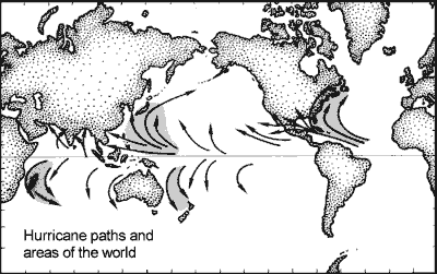
following immediately. As this map shows, Niue is not located in an area
frequented by cyclones. The previous one (Ofa) occurred in 1990 and the
one before that in 1979. Tropical
Cyclones (hurricanes, typhoons) are spiralling winds moving towards a centre
of low pressure. Ironically, they are spawned above warm seas in still
wind conditions. The energy contained in water vapour rises, causing updrafts
but at height where the temperature drops as the air expands, it condensates
to form very small droplets as cloud. These clog together to form rain,
which causes a down draft. The circular rings of updrafts and down drafts
then form a powerful motor for drawing air from far around towards its
centre and a tropical cyclone is born. Over several days above a warm sea,
such a hurricane can increase its size and strength to monstrous proportions.
Likewise, hurricanes lose their strength over land or over cold seas, and
as they die, they produce torrential rains. Their occurrence is felt long
afterwards in irregular weather patterns and an unusual period of drought
following immediately. As this map shows, Niue is not located in an area
frequented by cyclones. The previous one (Ofa) occurred in 1990 and the
one before that in 1979. |
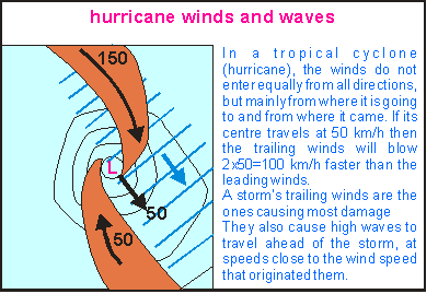 The
winds around a hurricane do not blow equally fast from all directions,
and neither are the waves underneath such a rotating storm of similar magnitude.
As a cyclone wanders, its centre may attain speeds of 20-50km/h. Winds
coming from behind then have to catch up with the cyclone's centre, so
that they are more powerful than those coming towards it. The waves produced
by the trailing winds are as a result much more powerful such that a hurricane's
left flank (in the southern hemisphere) is the most damaging one. As cyclone
Heta passed 70km west of Niue, it presented its most devastating flank
to the island. The
winds around a hurricane do not blow equally fast from all directions,
and neither are the waves underneath such a rotating storm of similar magnitude.
As a cyclone wanders, its centre may attain speeds of 20-50km/h. Winds
coming from behind then have to catch up with the cyclone's centre, so
that they are more powerful than those coming towards it. The waves produced
by the trailing winds are as a result much more powerful such that a hurricane's
left flank (in the southern hemisphere) is the most damaging one. As cyclone
Heta passed 70km west of Niue, it presented its most devastating flank
to the island.
Should a hurricane pass straight overhead, one would experience first a wind from the right, then a period of calm (its centre) followed by winds from the left. The sea directly in front of a tropical cyclone is whipped up one way, to be neutralised by opposing winds once the TC passes. It is the best place to be. |
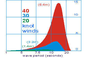 A
property of waves is that their energy increases rapidly with wind speed,
after a period of exposure. The diagram here shows the energy spectra of
waves caused by 20,30 and 40 knot winds over a long distance and after
at least 24 hours to reach the maximum sea state. A 40 knot wind
(74 km/h) produces waves 16 times more powerful (2x2x2x2) than a wind of
half that speed (20 knot= 37 km/h). By comparison, cyclone Heta had winds
of 140 knot (260 km/h) and gusts even stronger (over 300km/h). Usually
both wind speed and direction keep changing such that the maximum sea state
is not frequently attained. Indeed, as the winds around a cyclone flow
in all directions, the waves cannot easily reach their maxima, but the
fact that cyclone Heta pursued a straight path for almost two days, allowed
waves in the forward direction to reach unusual heights. A
property of waves is that their energy increases rapidly with wind speed,
after a period of exposure. The diagram here shows the energy spectra of
waves caused by 20,30 and 40 knot winds over a long distance and after
at least 24 hours to reach the maximum sea state. A 40 knot wind
(74 km/h) produces waves 16 times more powerful (2x2x2x2) than a wind of
half that speed (20 knot= 37 km/h). By comparison, cyclone Heta had winds
of 140 knot (260 km/h) and gusts even stronger (over 300km/h). Usually
both wind speed and direction keep changing such that the maximum sea state
is not frequently attained. Indeed, as the winds around a cyclone flow
in all directions, the waves cannot easily reach their maxima, but the
fact that cyclone Heta pursued a straight path for almost two days, allowed
waves in the forward direction to reach unusual heights. |
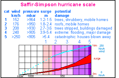 Scientists
Saffir and Simpson came up with a hurricane scale which expresses the storm's
damaging power in simple numbers but each step produces twice the damage
of the previous one. As one can see, the table stops at class five, which
is the worst conceivable storm with waves of 10m and a storm surge of 4-7m.
A storm surge is a bulge of water produced by the storm's low pressure
centre and winds mopping the sea towards it. Notice how the storm's surge
increases rapidly towards class 5 (red band) whereas wind speeds increase
more gradually (blue line). Together with this diagram, please read the
complete
table describing the kind of damage caused and how (un)likely such
a storm is. Scientists
Saffir and Simpson came up with a hurricane scale which expresses the storm's
damaging power in simple numbers but each step produces twice the damage
of the previous one. As one can see, the table stops at class five, which
is the worst conceivable storm with waves of 10m and a storm surge of 4-7m.
A storm surge is a bulge of water produced by the storm's low pressure
centre and winds mopping the sea towards it. Notice how the storm's surge
increases rapidly towards class 5 (red band) whereas wind speeds increase
more gradually (blue line). Together with this diagram, please read the
complete
table describing the kind of damage caused and how (un)likely such
a storm is.
A storm with the strength of cyclone Heta is a once in a thousand years event where hurricanes occur, causing large overwash and extensive damage on a regional scale. In fact it has been reported that 80% of all foliage on the island has been stripped off, which destroyed also crops and fruiting trees. All plants have furthermore received so much salt spray that their remaining leaves may eventually turn brown and die. |
| What is it like?
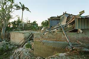
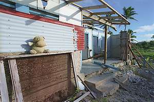
Experiencing cyclone Heta as Niue did, is a most frightening experience. There is first the expectation and preparation. After all there was Ofa in 1990, and others in 1979, 1960 and 1959, which have taught how to survive. Windows are battened down and securely shut; movable objects are stored out of storms way; antennas are taken down and anything else that may break; people prepare to bunker down in secure places to let the storm take its course. The weather forecast in these remote areas is not very precise due to the lack of weather stations that produce actual data. The weather station of Niue must have been taken out by the storm, as have also all communications. Then the storm arrives - gradually - causing more and more unstoppable damage. The sound is deafening. Water droplets propelled at 250km/h can cause lesions to the skin [1]. One cannot face the storm. Everywhere debris and broken goods are flung into the sky or propelled over the ground with fatal velocities. Houses start to break as their roofs become airborne. Suddenly a house gives way to be destroyed completely. People flee to safer spots. Some have to weather it out behind a tree, sheltering inside its roots, as they can no longer move around. Then the water comes. Wave after wave, reaching ever higher and with their enormous strengths washing sheds, houses and workshops into the sea. Despair sets in: how much worse can it get and how much longer will it take? This storm is so much worse than anything experienced before! And it does get worse and the end seems so far away. Then the storm abates slowly, finally reaching a point where people, the strong men first, can creep out of their shelters to see what has happened. The place is unrecognisable. Everything has been shifted or torn down with strange objects everywhere. People have died. The aftermath is concerned with finding out if there is anything left that still works. The telephones are dead and if it weren't for the recent technology of satellite phones, the news of Niue's plight might not have been able to reach the world. Electricity is down. Sewage pumps are not working. There is no running water. Everything is waterlogged - in salt water. People have nowhere to stay. They have lost all they had. Crops and future income have vanished too. It's a true disaster. How can we ever recover? [1] A man stood in the rain all night and experienced the rain. Although it hurt, it did not pierce his skin. |
| Richard StClair in a 'white paper' of the Internet
Users Society of Niue (IUS-N) writes:
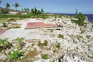
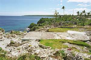
"Again, dodging downed trees, power lines, chunks of houses, we make our way to town. Coming down the hill we see the treasury building and police station . . . . around the corner and down main street south. Heavy damage to all the buildings we see. The roads are a mess. Trees down everywhere. Rocks the size of small cars in the road and in people's yards. We don't know it yet, but that is nothing compared to what we are going to see in a few minutes. The IUS-N office and Internet Cafe are still there but the roof is gone. Part of the roof is behind the building, the rest could be anywhere. The ceiling inside the office itself actually has protected the inside room from most of the ocean spray . . . . Leaving our downtown office for the moment, we drive to Alofi South (the south side of Niue's capital city), we travel only a short way when suddenly realize, it's basically gone. The road is there, we see where we think we should be, but there is nothing recognizable. Eventually we see some parts of some buildings that survived, and realize we are in front of Alofi Rentals, Niue's car rental service. Across the street we see the place where Ernie Welsh's house used to be. It's not only gone but the only hint there was ever a house there is the cement foundation that is not only cleaned off completely, but polished shiny from the sandy ocean water rushing over it through the night. The Niue we have known all these years is truly gone. It is a different island and a different country. Hundreds are homeless, the hospital is a total loss, the flagship Niue Hotel is in total ruins, the diveshop is gone, the museum and cultural centre are gone, the land court is destroyed. We can only imagine what the rest of the island looks like, since we are unable to drive there. Most of the roads are closed and we can't spare the fuel anyway, since we've heard that Niue's only petrol station has been damaged. We also know the main fuel tanks by the ocean (wharf) have been damaged and are leaking fuel into the ocean. Eventually the realization of what has actually happened, starts to sink in. People are milling around looking through the rubble for clothing and personal effects. Over the course of the next few hours we will learn that Kathy Alec, a young 26 year old nurse has given her life as a human shield in an attempt to protect her two year old son when the tsunami crashed her house. A few weeks later, after an incredible fight for his life, we also learn that the toddler she died trying to save, simply can't recover and succumbs to his injuries. . . " |
 |
 |
 |
 |
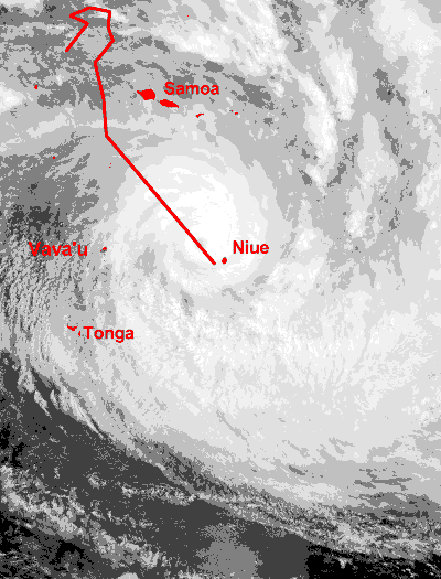
This satellite image shows cyclone Heta as it bears down on Niue. The image has been pixellated to show the storm's structure. The storm was spawned on New Year's Day 2004 in an unpopulated area of the Pacific Ocean and fortunately most of its course remained over open water. First it deviated northward threatening the Tokelau Islands (2 Jan), where some damage occurred. Then it veered down and around Western Samoa (3-4 Jan), as it gradually gained size, strength and speed. Its last lap was a two day journey (5,6 Jan) heading straight for Niue, passing about 70km west of the island. This long, straight course of 600-700km allowed the storm to whip the sea to its left and in front into mountainous waves accompanied by a high storm surge. The most devastating winds came from the north and north-east while the most damaging waves came from north to north-west. After causing massive damage to Niue, it continued its journey over unpopulated areas of the Pacific Ocean where it rained out and died. |
The odds of Heta
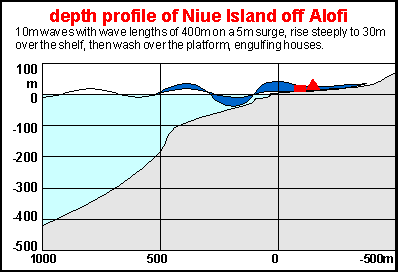 If
a class five hurricane is a one in a thousand year event for those places
frequented by hurricanes, the form of Niue's coast made the event even
less likely. This diagram shows the shore profile of Niue off its capital
Alofi. The land gradually slopes down from +50m to sea level, with most
houses between 20m and 30m above sea level. Outside a coral intertidal
fringe, the sea drops to 10m until the edge of the coral fringe where it
drops quickly to 30m. Beyond a kind of continental shelf of no more than
400m wide, the sea bottom suddenly sinks to 200m and then more gradually
to 3000m outside the diagram with inclines of 1:7 to 1:5. Note that the
vertical scale has been exaggerated only slightly. If
a class five hurricane is a one in a thousand year event for those places
frequented by hurricanes, the form of Niue's coast made the event even
less likely. This diagram shows the shore profile of Niue off its capital
Alofi. The land gradually slopes down from +50m to sea level, with most
houses between 20m and 30m above sea level. Outside a coral intertidal
fringe, the sea drops to 10m until the edge of the coral fringe where it
drops quickly to 30m. Beyond a kind of continental shelf of no more than
400m wide, the sea bottom suddenly sinks to 200m and then more gradually
to 3000m outside the diagram with inclines of 1:7 to 1:5. Note that the
vertical scale has been exaggerated only slightly.
The amplitude and length of the most devastating waves is also shown to size. Because the continental shelf is too narrow, it is unable to absorb the waves' energy. Instead it slows them down while increasing their heights up to three fold (dark blue). Waves of up to 30m high run up the natural ramp, then crash over the coral fringe, washing inland for hundreds of metres at speeds of around 100km/h. Overwash of this nature destroys and annihilates everything in its path. |
A class five hurricane is a very rare event but in the El Niño years (92-94, 02-04) when the Pacific gyres (large eddies) come to a halt, the tropical warm water is no longer transported to cooler areas like New Zealand. Consequently the heat builds up in the tropics, as at the same time New Zealand experiences cold seas. In the tropics the corals suffer from coral bleaching while in New Zealand dense plankton blooms cause other threats. During such conditions one can expect tropical cyclones to become more powerful than in other years. Niue just had an exceptional dose of bad luck.
the wrong time, wrong place, wrong shore
| What next?
Niue, the world's smallest self-governing nation has been self-governing in free association with New Zealand since its independence on 19 Oct 1974. Its small economy is substantially bolstered by the New Zealand taxpayer, as the Niuean economy is not able to sustain the necessary infrastructure for a decent life for all. Australia provides around $900,000 a year in bilateral assistance and NZ $8.2 million. Most Niueans have chosen to live in New Zealand, thereby relieving their homeland from the potentially devastating consequences of overpopulation (5200 in 1966). But most are also determined to maintain their cultural links with their past and their language while carefully accepting some benefits of the modern world. |
Private insurance is not working for low lying islands in the Pacific as insurers cannot make profits against the perceived and real high risks against low asset values. Fortunately a network of social support exists, with New Zealand taking the leading role in helping Niue after Heta. (But French Tahiti silently came to help with an energetic and experienced team, backed by heavy machinery. Their massive practical contribution to the clean-up is praised by all and will not easily be forgotten). A donor team comprising representatives from Australia, France, Britain, Germany, Canada, Japan and Fiji are working with New Zealand authorities to help with the relief efforts. New Zealand's 20,000-strong Niuean population has been raising funds and providing volunteers to help their homeland. About 2000 Niueans live in Australia and are also arranging assistance. Those on the island are now trying to recover, but with so much damage the process will take time. Australia's Westpac Bank is providing very basic services from its damaged branch in Alofi, which since 1988 has been the only commercial bank operating on the island. The European Union is to provide $US766,700 to rebuild Niue after cyclone Heta.
Even so, the future looks grim for those prepared to give up easily. Niue's fledging economy based on tourism and coconut & fruit tree plantations was just showing promising returns as the cyclone hit. Both have been seriously set back, as have most of the popular coral reefs and the whole dive operation that made this paradise accessible to visiting tourists. The effect of the storm on local flora and fauna can only be guessed at as fruits for fruit bats and birds, and leaves for insects have become very scarce.
Related issues on this web site:
Trapped
waves: the oncoming cyclone Heta accelerated in almost a straight
line, sufficient for massive trapped waves, arriving with little warning.
An extensive chapter about Niue,
its geography, history and ecology. A must-read for those interested in
this island nation.
Seafriends chapter on storms
oceano/storms.htm
and wavesoceano/waves.htm, and
more popularly in indepth/storms.htm
Storm classification table oceano/stormcls.htm
contains details and occurrence rate of hurricanes class 1 to 5.
Kermadec
Islands: a biogeography of NZ islands lying 1400km southwest of
Niue. What it is like to
make a living on a remote live volcano 1/9th the size of Niue.
External Links:
www.reliefweb.int
a record of press releases and relief actions for Niue and other disaster
areas.
www.sopac.org.fj
South Pacific Applied Geoscience Commission: to mitigate natural disasters
in the Pacific Islands. Also has interactive maps of these islands. SOPAC
is mandated to contribute to sustainable development, reduced poverty and
enhanced resilience for the people of the Pacific by supporting the development
of natural resources, instigating natural systems and the reduction of
vulnerability through applied environmental geosciences, appropriate technologies,
knowledge management, technical and policy advice, human resource development
and advocacy of Pacific issues.
www.worldhurricanes.com
follows the presently raging storms all around the world.
MODIS
rapid response system has been developed to provide rapid access to
MODIS data globally, with initial emphasis on 250m color composite imagery
and active fire data obtained from geo satellites. It has photos of cyclone
Heta over Niue.
CIA
factbook with vital statistics of Niue.
Lonely
Planet guide of Niue: more facts and maps of Niue
www.niue.nu:
a web site devoted to Niue and its commercial activities.
-- Seafriends home -- indepth
index -- site map -- Rev: 20040122,20041020,20060808,20090115,