by Dr J Floor Anthoni (2004-2005)
www.seafriends.org.nz/niue/geo.htm
This chapter deals with general information
about Niue, like where it is located relative to other Pacific islands,
and the size and shape of its territory covered by its EEZ. This chapter
also delves into Niue's long past, speculating about when it was created
and what happened to it since. Today Niue is a coral rock on top of an
undersea volcano with properties not easily found elsewhere in the world.
It is surrounded by a deep ocean for its entire Exclusive Economic Zone,
with the exception of Beveridge Reef which may well be unique. The calcite
rocks that cover the entire island have weathered to form tropical soils,
and they show that tropical cyclones have always been plaguing Niue.
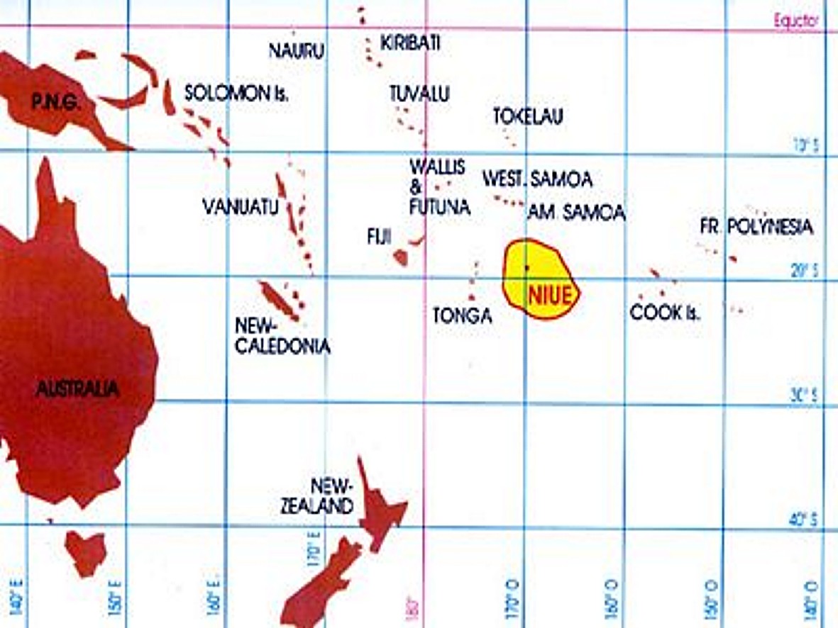
Niue in the Pacific Ocean Niue
is a very small island, located NE of New Zealand, East of Tonga, West
of the Cook Islands and South of Samoa. The map shows Niue in the central
Pacific, and its Exclusive Economic Zone (EEZ) in yellow. Niue is rather
unique in being only an isolated island rather than an archipelago. This
uniqueness has its influence on the marine life found along Niue's coasts,
as it lacks an interconnected 'network' of places to live. The larvae of
marine species are thus easily lost in the blue sea, as they drift off
into an environment lacking planktonic food. Niue's isolation has also
had its effect on Niue's history, culture and wellbeing.
To obtain a sense of distance, the map shows a grid spaced by 10 degrees.
As the meridians (N-S) are of same size ans the parallels (EW), the grid
consists of almost perfect squares. Each square measures 10x10 degrees
and each degree is 60 nautical miles (nM), or 60 x 1.85km = 111km. Each
square thus measures roughly 1100x1100 km.
Memorise Niue's position on the world map so you can locate it on other
world maps used in this section. Niue's position is 19 degrees South by
170 degrees West, or ten degrees East of the date line.
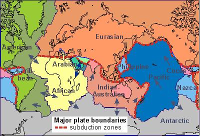
Niue
is located on the Pacific sea plate, coloured here in blue. The world's
surface area consists of several sea plates and continents. These are not
static, but move slowly (drift) relative to one another. The Pacific Plate
moves steadily at about 1cm per year in a NW direction. That may not seem
much, but when Niue was still an active volcano, peeping its top above
the sea, some 2-3 million years ago, Niue was located some 2 million cm
further South-East (20km).
Located just East of the deep Kermadec Trench, Niue is moving slowly
towards this trench and in hundreds of millions of years in the future,
will be swallowed up by the Kermadec Trench and pushed underneath the Indian-Australian
plate. However, this is of no concern today. It does explain, however,
why so few islands exist East of the Kermadec Trench, which leaves Niue
rather alone by itself.
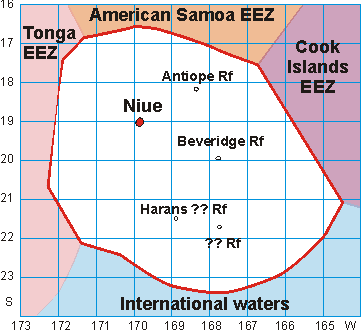
Niue's ocean area Niue's
ocean territory has recently been defined by its Exclusive Economic Zone,
an ocean territory encircling every outcrop of land. As Niue has only two
submerging parts (Niue and Beveridge Reef), these form the centres of two
circles of 200nM (370km) radius, covering a total area of 390,000km2, and
extending from W164º to W172º30' and S16º30' ro S23º30'.
Where these circles interfere with those of other nations, the sea is divided
between competing nations. In this manner Niue borders the EEZ of Fiji
in the West, American Samoa in the North and Cook Islands in the East.
Its southern boundary is uncontested, bordering international waters. Notice
that the grid marks degrees of latitude and longitude, which so near the
equator are almost equal, measuring squares of 60nM (= 111km). Beveridge
Reef lies about 130nM from Niue.
Ships have traversed this sea, noticing two more reefs, Harans Reef
and another reef:
Beveridge Reef is an undersea mountain capped by a
coral atoll 20º00S 167º47'W. It encloses a lagoon about 4 nM
long in a NS direction and about 2nM wide. Apart from breaking seas, the
reef is not visible (Pacific Islands Pilot, 1984). (see below)
Antiope Reef 18º14S, 168º20'W was reported
in 1886 by British ship Antiope, about 3 cables long N/S direction and
1.5cable wide. The sea broke heavily over the centre of the reef. In 1984
this reef was reported to lie about 1nM SW of its charted position and
to have a depth of 9.5m over it (Pacific Islands Pilot, 1984)
Harans Reef (21º32'S, 168º54'W was reported
in 1848 by Mr Harans of the ship Thomas Dickenson. The reef was passed
at night and the sea broke heavily over it, apparently for about 2 ship's
lengths. Its position is now doubtful but new maps show a sea mount over
1000m deep where it was reported. Mr Harans could have seen volcanic gases
breaking the surface.
Another reef, the existence of which is doubtful,
was reported in 1965 to lie in position 21º43'S, 167º45'W, 60nM
E of Harans Reef (Pacific Islands Pilot, 1984). This reef is now a myth.
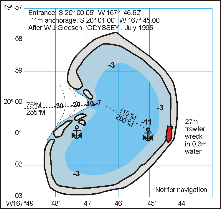
Beveridge
Reef As reported by W J Gleeson of the Odyssey in July 1996, Beveridge Reef
only barely extends above water, offering shelter to boats who can negotiate
its 7m shallow entrance sill. The reef is rather large, about 5 x 4 nM
or 9.5 x 7.5 km, about half the length and width of Niue and one quarter
its area. As it is also subjected to the SE trade winds and swells, best
anchorage is towards the wreck of a 27m (90FT) trawler on a course of 110º
Magnetic. On this course, coral bommies leave about 6m of water above them.
This anchorage provides best shelter against the SE trade winds. A good
dive spot is reported just south of the entrance at the eye of the anchor
symbol. Please note that this is a hand-drawn chart, not suitable for navigation,
but its GPS co-ordinates are more reliable than those on present nautical
charts. Click on the map for a larger version.
A latest report (2004) mentions that the trawler wreck has become invisible.
Shallowest part of entrance: S 20º 00.06' W 167º 46.62'.
The anchorage at 11m is at S 20º 01.00' W 167º 45.00'
Unlike Niue, Beveridge Reef does not emerge like a raised atoll. Its
rim and lagoon are still being built by coral organisms that need to stay
submerged in order to grow. This suggests that Beveridge Reef is rather
young, from after the last ice age, as the waters rose to what they are
now, some 14,000 years ago.
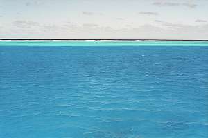
bevr07t: the rim of the Beveridge lagoon comes to high tide
level as waves outside break over it. Inside the lagoon, the water looks
milky due to the white sand below at 11m depth. Photo: Greg Gibbs.
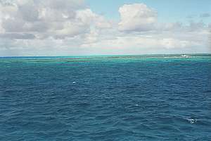
bevr10t: Outside the reef, the sea drops off steeply into
a giddying blue sea at the entrance to the lagoon. Photo: Greg Gibbs FV
SAVANNAH.
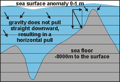
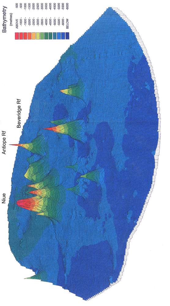
Bathymetry In
1978, an experimental satellite was launched to study the oceans. One of
Seasat's instruments was a radar altimeter, able to measure the ocean's
surface from an altitude about 500 miles up, with a precision of 5-10 cm.
Surprisingly, the surface of the ocean proved to be curving and dipping,
often by as much as 10m up and down (for 5000m bottom relief). When mapped,
the dips corresponded to dips in the sea floor and the bumps to sea mounts
and ridges. The precision of the measurements allowed computers to make
precise and detailed maps of the entire world's ocean floors.
The reason these dips and bumps occur in the ocean's floor, without
ships ever being able to notice these, comes from the force with which
two substance attract one another - the heavier earth's crust attracting
the lighter and fluid water. Thus undersea mountains pull water towards
them, resulting in a surface bump, whereas ocean trenches have the opposite
effect.
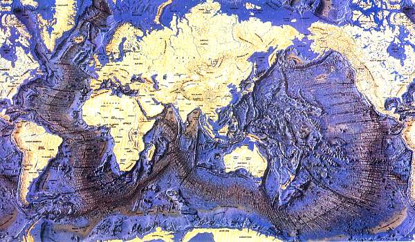
The above map shows the world's ocean sea floor. The broad bands with parallel
lines is where the ocean floor spreads, and where new ocean floor is created.
The thick black lines are the deep ocean trenches where ocean floor is
subducted, disappearing underneath some other ocean plate or continent.
Along these trenches one finds the world's active volcanoes or 'rings of
fire'.
To be more precise, disturbances
of the gravity field created by non-homogenous mass distribution within
Earth cause deformations of the sea-surface. These sea-surface deformations
are measured by satellite altimeters on board oceanographic satellites.
The short wavelength variations (20-250km) of the geopotential anomalies
(or sea-surface anomalies) are strongly correlated with the seafloor topography,
because the latter is the shallowest interface which produces geopotential
perturbations at the surface of the oceans. Satellite altimeter data was
obtained from SEASAT, GEOSAT (Exact Repeat Mission), ERS-1, TOPEX/POSEIDON.
The accuracy of the seafloor
computed depth is better than 10% of the mean seafloor depth (better than
500m for Niue EEZ), and the horizontal resolution is about 5 km. But the
satellites, in their rather precise orbits, have not crossed over every
bit of ocean, leaving gaps between their tracks.
The resulting undersea map of Niue's EEZ looks stunning as shown above.
Click on the map for a larger version that prints on an A4 sheet (niueez4.jpg)
The abyssal seafloor is made up of lower Cretaceous oceanic crust (100-140Mya)
with depths between 5000-5500m. Volcanic activity has created two groups
of sea mounts, one with Niue and the other with Beveridge Reef.
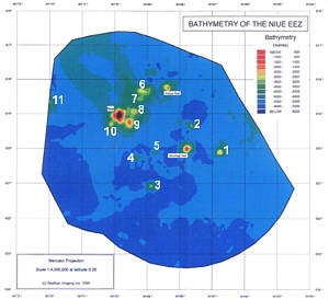
Seamount No
Latitude S
Longitude W
Estimated summit depth
1
20º 7'
166º 45'
Shallower than -2000m
2
19º 21'
167º 38'
Shallower than -3000m
3 'Harans Rf'
21º 5'
168º 53'
Shallower than -2100m
4
20º 17'
169º 20'
Shallower than -2800m
5
20º 8'
168º 45'
Shallower than -2700m
6
18º 20'
169º 5'
Shallower than -2500m
7
18º 35'
169º 7'
Shallower than -3000m
8
18º 57'
169º 24'
Shallower than -1300m
9
19º 14'
169º 33'
Shallower than -500m
10
19º 18'
170º 7'
Shallower than -1800m
11 Capricorn SeaMt
Lies much further E, shared
with Fiji
Only seamounts 1 and
2 had been reported previously.
Sea mounts within the Niue
EEZ
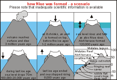
Niue's distant past Niue
is an old and inactive volcano that rose above the sea before it died.
As its soft cone eroded by weather and waves, it also shrank as its core
cooled. During this slow process, a coral reef formed on its top, the Mutalau
Reef, named after the island's present highest point. The reef kept up
with the sinking rate of the volcano, laying down a coral cap of possibly
70 + 130m = 200m. The diagram on right aims to visualise what happened,
but hard scientific information is not yet available. Because of the Pliocene-Pleistocene
fossils found in what was then the atoll's lagoon, the limestone cap must
have formed before the severe ice ages of the Pleistocene (1.6 million
years ago to 10,000 years ago). No tertiary fossils were found (56 million
to 2 million years ago). During the long period of the great ice ages in
the Pleistocene, the sea level rose and fell while the world's climate
was cooler by several degrees. It is not likely that much coral formed
during that cold period.
The Alofi Terrace may have formed during the penultimate interglacial,
some 150,000 years ago when sea level stood 25-50m higher than today. In
the meantime the interior developed its soils, which today are much more
advanced than those on the younger Alofi terrace.
During the last ice age, the sea level fell by 70-110m and as it rose
at the end of this period, some 10,000 years ago, it laid down more coral
reef and eventually the 'wave-cut' terraces of today. Ironically, the sea
level did not rise to the Alofi Terrace, as in New Zealand the present
dunes are overlaying ancient dunes. This is perhaps due to Niue still rising
slowly. At present, sea levels around New Zealand appear to be rising by
30cm in a century, a rate that corals can keep up with at present high
temperatures. The coralline flats surrounding the island at low tide mark,
suggest that Niue is also rising at this rate, for if this were not so,
the flats would have been dry at all times.
Please note that the name Alofi Terrace refers to the 20-30m high terrace
surrounding the entire island, and not just the terrace found at Alofi.
Likewise the Mutalau Lagoon refers to the entire inland basin, and the
Mutalau Reef is the entire high ridge around the island.
The
diagram on right shows tropical sea temperatures (red) and mean sea levels
(blue) for the past 300,000 years. Plaeontologists distinguish four ice
ages: Wuerm, Riss, Mindel and Gunz with warm interglacial periods in between
(Sicilian, Milazzian, Tyrrhenian, Monasterian and recent Flandrian). During
all of this time, Niue was located at the southern fringe of where coral
grows faster than erosion by wave action and natural dissolution of limestone
in water. Follow the red curve for all the periods extending above 26-27ºC.
During these periods, Niue grew, whereas during the inbetween periods,
Niue must have shrunk due to insufficient coral growth (the higher the
temperature, the better corals grow). Follow the blue curve, and it shows
that some 250,000 years ago, the sea level stood 100m higher. Further back
in time, it stood higher still. Thus the Mutalau Reef and lagoon may have
been formed during warm times when the sea level stood 100m higher than
today. Fossil shells show that this happened some 1 million years
ago but this date is uncertain. Niue may have formed in the Sicilian interglacial
when the sea level stood above the Mutalau Reef. The Alofi Terraces may
have formed in the Milazzian and Tyrrhenian warm interglacials (120,000
- 170,000 years ago) and another accretion may have happened some 80,000
years ago. These successive periods of accretion and erosion may have caused
discontinuities in the Alofi Terraces with alternations of weak and strong
rock, resulting in chasms seen today, explained by geologists as faults.
Please note that sea levels
are difficult to determine, due to continents sinking under the load of
glaciers, and rising again in warm periods.
Fairbridge R W (1961): Eustatic
changes in sea level. Physics and Chemistry of the Earth 4:99-185
Zeuner F E (1959): The Pleistocene
Period. London.
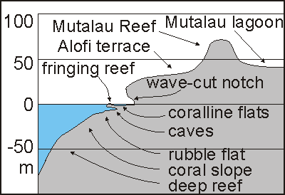
Shore line The shoreline of Niue is remarkably alike, all around the island but
it assumes different shapes depending on wave exposure (the wild side)
and damage from hurricanes (the sheltered Alofi side). In the chapter about
the island's ecology,we'll come back on this.
This
diagram shows the general cross section of the shore line. From right to
left, one leaves the ancient Mutalau Lagoon of 30-40m height, crossing
the ancient Mutalau Reef of 45-75m to descend onto the Alofi Terrace of
20-27m height. Descending over one of the ridges, one comes to a steep
dropoff of 6-20m height, undercut by a wave-cut notch of several metres
high. Going down a heel of 0.5-2.5m, one arrives at the coralline flat
which is bordered by a slightly higher fringing reef. Underneath the coralline
flats extends a maze of caves, at times opening up into blow holes and
seething canyons. At about 6-12m the rubble collects onto sandy flats,
alternated by coral-clad ridges, leading down a gentle slope to 25-30m
depth where the slope becomes steeper, the deep reef with corals able to
live in diminished light, while unaffected by storm waves. There exists
a remarkable difference between the exposed SE coast and the sheltered
but hurricane-torn NW coast.
This
view, looking south from Tuapa (N of Alofi), shows the typical shape of
Niue's shoreline. From the sloping Alofi Terrace on left, ridges run into
the sea, alternated by steep valleys. Both end in a platform that extends
further out into sea before it rises into a knee-high ridge, the outer
reef. From there it drops down to 6-10m, where it descends more gradually.
In their reports, geologists speak of wave-cut platforms, but we disagree.
These platforms were formed in recent times, mainly by the growth of coralline
algae, with here and there a true coral of the types able to suffer fresh
water immersion and exposure to air (Porites and Acropora
species). The flats are entirely flat and horizontal as low tide is the
decisive limitation for growth. Underneath one finds extensive cave systems.
The wave-cut notch is caused by wave erosion but where sea life persists,
there exists a ledge or heel, the erosion of which is slowed down considerably
by encrusting marine life.
Soil Soil is the precious substance that allows plants to grow, and grazing
on them, the animals. Normally soil is formed from hard rock such as basalt,
granite and volcanic debris. These rocks were formed under high temperatures
and pressure, and they very slowly decompose (weathering) in atmospheric
pressure, particularly under the influence of moisture and acids. Plants
retain moisture while providing for acids from their decomposing tissues
(leaves, stems, roots). So the development of soils goes hand in hand with
the flora growing on and in it. With it develops the soil fauna, often
unique to a particular location. But how does this happen in limestone?
The limestone of coral islands like Niue consists of two to three kinds:
coralline rock: although corals are the highly visible structures
on a coral reef, the coralline algae that grow like a paste or paint, layer
upon layer, leaf upon leaf, make up the bulk of the reef structure. It
is in fact seldom seen that a new coral grows on an older or dead one.
First the coralline algae form a new base upon which new corals then settle.
The coast facing hurricanes has very few corals and rocks here are mainly
formed by pink paint, at times enclosing broken fragments or coral debris.
Pink paint is a porous rock, diffused by plant tissue. When it dies, this
tissue or the nutrients from it, remain inside the rock. When it weathers
under soil, which is easy because it is not very hard, the nutrients are
freed up. This suggests that the soils from coralline rock form more readily
and that they are somewhat more fertile, but there is no scientific proof
of this.
coral rock: in warmer seas, the hard corals make up a large part
of the rock, although they may end up as debris washed up on a beach or
piled up against a coral cay. In Niue all corals are encased in pink paint,
but the side facing the trade winds has rock containing more hard corals.
Hard corals contain animal tissue in relatively large pores inside. when
corals die back or 'bleach', they lose (or re-use) the animal tissue. As
a result, they contain hard limestone but with fewer nutrients. Again,
this has not been proved scientifically.
coral sand or cemented coral sand: inside the Mutalau Lagoon or
the central basin of Niue, one finds much limestone formed from coral sand.
When such limestone has been percolated through from layers above it, it
may become cemented and hard like dripstones in a cave. Coral sand can
originate from coral debris being ground up by wave action, but most originates
from grazing fish, particularly parrotfish, scraping soft coralline rock
and passing it through their digestive systems physically unchanged but
with less algal tissue inside. Where substantial shelves (like continental
shelves) exist around reefs, the sand may be retained on sandy flats and
beaches but Niue loses most of it down the steep slope into the deep sea
around it.
As soil develops from the base limestone rock, it loses (eluviates) minerals
that are not needed by plants and soil animals (including fungi and bacteria),
while retaining and accumulating those it needs. As can be seen from the
soil table below, rarer elements like aluminium, iron and titanium are
accumulated whereas the common unused minerals calcium and magnesium are
lost. Note that the aluminium and iron compounds are not used by plants
and animals but they form what looks like soil, the substance able to retain
nutrients, and for plants and soil animals to live in and on.
The soils in Niue are not lost by erosion, sheet-wash and transportation
in rivers towards the sea. Niue has no rivers but rain water disappears
through the many fissures, tunnels, channels and cavities in the coral
rock. With it, soil also disappears into the limestone rock rather than
remaining on top. So, trees with deep roots can reach it and the moisture
it contains, whereas crops cannot. As a result, agriculture on Niue is
susceptible to drought even though rainfall is double (2100mm) that of
Auckland (1100mm), New Zealand.
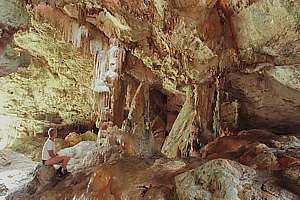
Limestone
is dissolved by the small amount of carbondioxide that dissolves in water.
The air around us contains very small concentrations of carbondioxide,
only 40 molecules for every million. Those molecules that dissolve into
water, exist in equilibrium (balance) with those outside, such that the
concentration of the acid it forms, is indeed very low. But this small
amount attacks limestone rock fiercely, dissolving it into the water. In
this manner the other elements in the rock are freed up, enabling the formation
of soil where plants and soil biota (worms, bacteria, fungi) exist. Where
the infused water (with calcium in it) dries up, such as on dripstone formations,
the limestone is again laid down layer by layer, in a very hard form. Where
algae are present due to available light, such dripstones may assume wonderful
palettes of colour, such as in the Avaiki cave.
The chemical equation below shows how limestone with water dissolves
into calcium ions and carbonic acid ions:
CaCO3 + H2O = Ca++ + 2HCO3-
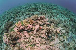
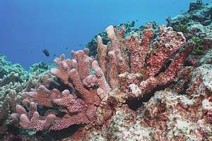
f044711: this coral seascape is the best Niue can offer,
located on the wild side of the island. It is rich in coral 'shrubs' but
notice also the amount of empty space inbetween, covered by coralline algae
(pink paint), which grows over old corals, creating the substrate for new
ones.
f044920: a pink branching coral is slowly dying from right
to left and already its rightmost branches have completely been grown over
by pink paint. Gradual die-back and recolonisation by coralline algae appears
to be normal.
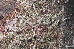
f043705: scratch marks from grazing fish. In scraping nutricious
algae from the rock, they unintentionally also scrape off some rock,
which becomes sand after passing their guts.
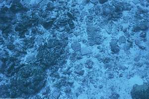
f043927: off Alofi and Avatele one finds flat areas and gulleys
filled with coral sand and rubble. This photo was taken with a 28mm lens,
looking down some 10 metres.
Geologists have distinguished
three kinds of limestone: reef rock, beach conglomerate and cemented or
loose coral sand. The most striking character of the reef rock is its low
content of macroscopic (visible) coral fragments, which are entirely absent
from some exposures. This indicates that these reefs were built by coralline
algae rather than coral.
The
middle of the island was once the atoll's lagoon, and it is still mainly
flat today. The surface rocks of the basin are all calcarenites
and commonly contain mollusc shells. The sand is cemented on about 60%
of the area and incipient (beginning) karrenfelds have developed
leaving residual pinnacles commonly rising about 5ft above the adjacent,
flat, uncemented sand.
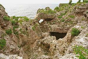
On the outer side, reef rock
is exposed in the steep bluffs down to the younger Alofi Terrace. It consists
of fine to coarse, cemented, unbedded sand containing rare coral fragment,
most being found in the south. The rock on the margins and the highest
remnants was carefully examined across eight sections and was found to
be reef rock similar to that on the outer slopes. No beach conglomerate
or cemented beach sand was seen. The photo shows typical limestone formations
at Alofi on the hurricane side of the island.
The
southern coast is attacked by the full force of the prevailing winds, and
the effect of constant spray has produced an entirely different landscape
from that in the more sheltered coastal areas. Instead of it being cliffed,
it is backed by a slope of 17-22º leading from sea level to the Alofi
Terrace. This slope is bare of vegetation and is exceedingly rough, being
a karrenfeld of crevices and razor-sharp pinnacles. Blowholes add
beauty to this desolate coastline.
[Source: Schofield J C (1959)
The geology and hydrology of Niue Island, south Pacific. DSIR Bull 62]
Shores deformed by hurricanes From our observations, and
supported by Schofield's observations on the differences in limestone between
the exposed and sheltered coasts, we propose (hypothesise) that the limestone
on the sheltered Alofi side was shaped by the influence of hurricanes.
Underwater we see extensive barrens from which coral colonies are
repeatedly being removed by hurricanes, and their place taken by soft algae
growing on hard coralline algae. This process must have been ongoing for
as long as Niue has existed. As a result, the limestone rock on the hurricane
side are as erratic and jumbled as we also see under water, whereas the
rocks on the exposed side show more structure.
Dr Floor Anthoni, 2004
karren= (German:
karren=cart,
referring to their wheel tracks; feld= field) the furrows or runnels
that occur from solution by rain wash on limestone in karst areas. They
range in width from a few millimetres to more than a metre, and are commonly
separated by sharp ridges.
karst= (German: Karst
is a region in Germany) a type of topography (landscape) formed over limestone,
dolomite or gypsum by dissolution. It is characterised by sinkholes, caves
and underground drainage.
calcarenite= a limestone,
more than half of which consists of cemented sand-sized grains of calcium
carbonate; a consolidated calcareous sand. Note that coral sand is produced
mainly by the many coral-scraping fish like parrotfish. Inside a sheltered
lagoon, such sand would over time, build up, forming a habitat of its own
with sand-burrowing clams. But on the outside of the reef, the sand plays
a lesser role as it can be lost to the abyss.
phonolite= a group
of fine-grained extrusive (volcanic) rocks primarily composed of alkali
feldspar & mafic (dark ferro-magnesium) minerals.
fault= a fracture
or fracture zone along which there has been displacement of the sides relative
to one another parallel to the fracture.
barren= a barren
zone underwater caused by storms that remove plants and corals. The barren
rocks are covered in reef-building coralline algae, in turn covered in
soft algae and grazed by a multitude of grazers, from snails to sea urchins
to fish. (Floor Anthoni)
Mineral
lagoon basin average
limestone average
basalt
phonolite Rarotonga
human intake mg/day
SiO2 silica
0.80
0.48
44.4
51.8
-
Al2O3 alumina
35.93
0.23
14.3
20.34
-
Fe2O3 iron oxide
27.18
0.29
15.8
6.59
15/22
TiO2 titanium oxide
1.48
0.02
2.4
..
-
??O3
2.43
..
0.3
0.52
?
P2O3 Phosphorus
0.17
..
..
..
1000/1774
CaO Calcium oxide
1.29
44.62
9.8
3.92
1000/1400
MgO Magnesium oxide
0.17
8.57
8.6
0.6
300/500
Na2O Sodium oxide
0.12
..
2.8
8.36
3000/4040
K2O Potassium oxide
0.05
..
1.6
4.24
3000/3620
MnO Manganese oxide
0.21
..
..
..
10/13
Niue soils
compared with unweathered rock. After Schofield, J C (1959)
Note that this kind of soil
test 'burns' the sample, thereby changing the original compounds into oxides
Human daily intake as mineral
element and behind the slash as oxide equivalent
This table indicates that the soils of Niue are considerably richer
in aluminium, iron, titanium and phospate than the underlying limestone.
This is a part of the evidence advanced by Wright [1] to support the hypothesis
that basic volcanic ash has contributed extensively to the soil materials
of Niue. He notes in particular that Al2O3/P2O3 of the soil is more than
double that of the limestone. The ratios expressed in the analyses of the
Niue soils are reasonably close to combined Al2O3/Fe2O3 ratios of basalt
and phonolite, which are common in igneous rocks in the Pacific.
However, the way soils form from rock or limestone is governed by plants
and soil biota. All useful minerals in the right ratios will eventually
circulate between soil organisms and plants. When 20m of rock decomposes
into 0.5m of soil, there has been ample opportunity for the soil to retain
and accumulate all the minerals it needs while leaching those that are
in excess. There is no need for volcanic ash to explain the observed mineral
enrichment.
Note that Alofi Terrace soils, being much younger, have high calcium
content and low iron/aluminum content.
For more information, read the extensive Soil
section on the seafriends web site. And the abundance
table of elements in the solar system, soil and living organisms.
[1] Wright, A C S (1960?): Soils and agriculture of Niue Island. NZ
Soil Bur Bull.
Water Niue is located south of the tropical rain band but north of the desert
band around the world. Rain falls reliably in winter, between July and
December, but becomes erratic outside this period, resulting in unpredictable
droughts that have on occasion, destroyed crops (see history). Although
total rainfall is nearly twice as much as in auckland, New Zealand, it
all quickly soakes down into the porous coral rock.
But some 1-3m above sea level, the fresh water collects in a labyrinth
of channels and pores in the coral rock, in what is known as a water
lens. The diagram shows the possible shape of it. As the formulas show,
for every one metre above sea level, it must extend 37m down into the salt
water. Experiments done at the Fonuakula well showed that the water stands
between 1.8 and 3m above sea level. The well is pumped to supply fresh
water to important places like the hospital, but it cannot be overdone.
In theory this water lens could be tapped from the central basin to supply
water for agriculture, but this has not been investigated carefully enough
as agriculture needs a considerable amount of water, far more than that
needed for washing and flushing toilets, and the voulme of the water lens
may not be enough.
A dug well at Fonuakula
is 54.3m deep, supplying water to the Tufukia hospital near Alofi. Its
shaft is 1.5x1.2m wide, bored through the massive limestone. It can sustain
400 gallons/hr (1800 l/h). At 2m of rainfall per year, the input to the
water lens is 500 billion litres or 500 million cubic metres (5.0E11).
The water lens consists mainly of limestone with small pores. Assuming
an average depth of 50m, and a limestone porosity of 1%, the water lens
may contain some 120 billion litres (120 million cubic metres) of fresh
water.
Obviously, this water lens
cannot grow any bigger, and all rain water flows off it to the sea above
sea level. It is fascinating to see the many wells of fresh water spouting
their contents over the clear sea water after a heavy rainfall.
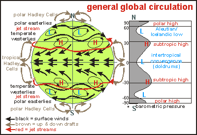
Climate Niue
is located south of the moist tropics but north of the dry subtropical
deserts. Warm moist air rises above the equatorial band, raining its moisture
over tropical rain forests. The dry high altitude air travels south-west
in a rotation known as the Hadley Cell. Above the subtropic high, the dry
cool air descends and warms up, becoming even dryer. From the subtropic
high the wind continues its Hadley spiral, now blowing as a south-easterly
trade wind, evaporating moisture from the sea and joining up with the tropics
again, where it deposits its load of moisture. This is why Niue experiences
long periods of trade winds blowing from the south-east.
[waiting for climate data]
Tides The tides do not move in the simple textbook way, as a bulge travelling
around the Earth (See Oceanography/tides),
but in circles running along the continental shores rather than head-on.
The map below shows how these circling waves form nodes (dark blue) without
any tide and high tide excursions inbetween (yellow to red). The spiderlike
web of white lines provides their timing. New Zealand forms an unusual
node with high tides and the tide wave encircling it counter-clockwise.
It joins up with the dark node east of Niue around which the tide moves
clockwise and so on.
Niue is located in the green band, experiencing a moon tide of 2 x 45cm=
90 cm. Note that the solar tide adds to this, resulting in a neap tide
and a spring tide of less than 1.5m twice each lunar month.
In Niue the tide would be inconsequential, except for it flooding the
coralline flats. When the tide is out, these flats and their many pools
can be visited. Small to medium waves then brush up to the surrounding
coralline rim, leaving the flats calm. During high tide and inbetween,
however, waves wash over the fringing rim and their returning water assembles
in sink holes and canyons, often causing a current too strong to swim against.
It all depends on the size of the waves of course.
Currents are not of concern in Niue but locals report strong currents
flowing around Tepa Point.
 Niue
is a very small island, located NE of New Zealand, East of Tonga, West
of the Cook Islands and South of Samoa. The map shows Niue in the central
Pacific, and its Exclusive Economic Zone (EEZ) in yellow. Niue is rather
unique in being only an isolated island rather than an archipelago. This
uniqueness has its influence on the marine life found along Niue's coasts,
as it lacks an interconnected 'network' of places to live. The larvae of
marine species are thus easily lost in the blue sea, as they drift off
into an environment lacking planktonic food. Niue's isolation has also
had its effect on Niue's history, culture and wellbeing.
Niue
is a very small island, located NE of New Zealand, East of Tonga, West
of the Cook Islands and South of Samoa. The map shows Niue in the central
Pacific, and its Exclusive Economic Zone (EEZ) in yellow. Niue is rather
unique in being only an isolated island rather than an archipelago. This
uniqueness has its influence on the marine life found along Niue's coasts,
as it lacks an interconnected 'network' of places to live. The larvae of
marine species are thus easily lost in the blue sea, as they drift off
into an environment lacking planktonic food. Niue's isolation has also
had its effect on Niue's history, culture and wellbeing.
 Niue
is located on the Pacific sea plate, coloured here in blue. The world's
surface area consists of several sea plates and continents. These are not
static, but move slowly (drift) relative to one another. The Pacific Plate
moves steadily at about 1cm per year in a NW direction. That may not seem
much, but when Niue was still an active volcano, peeping its top above
the sea, some 2-3 million years ago, Niue was located some 2 million cm
further South-East (20km).
Niue
is located on the Pacific sea plate, coloured here in blue. The world's
surface area consists of several sea plates and continents. These are not
static, but move slowly (drift) relative to one another. The Pacific Plate
moves steadily at about 1cm per year in a NW direction. That may not seem
much, but when Niue was still an active volcano, peeping its top above
the sea, some 2-3 million years ago, Niue was located some 2 million cm
further South-East (20km).
 Niue's
ocean territory has recently been defined by its Exclusive Economic Zone,
an ocean territory encircling every outcrop of land. As Niue has only two
submerging parts (Niue and Beveridge Reef), these form the centres of two
circles of 200nM (370km) radius, covering a total area of 390,000km2, and
extending from W164º to W172º30' and S16º30' ro S23º30'.
Where these circles interfere with those of other nations, the sea is divided
between competing nations. In this manner Niue borders the EEZ of Fiji
in the West, American Samoa in the North and Cook Islands in the East.
Its southern boundary is uncontested, bordering international waters. Notice
that the grid marks degrees of latitude and longitude, which so near the
equator are almost equal, measuring squares of 60nM (= 111km). Beveridge
Reef lies about 130nM from Niue.
Niue's
ocean territory has recently been defined by its Exclusive Economic Zone,
an ocean territory encircling every outcrop of land. As Niue has only two
submerging parts (Niue and Beveridge Reef), these form the centres of two
circles of 200nM (370km) radius, covering a total area of 390,000km2, and
extending from W164º to W172º30' and S16º30' ro S23º30'.
Where these circles interfere with those of other nations, the sea is divided
between competing nations. In this manner Niue borders the EEZ of Fiji
in the West, American Samoa in the North and Cook Islands in the East.
Its southern boundary is uncontested, bordering international waters. Notice
that the grid marks degrees of latitude and longitude, which so near the
equator are almost equal, measuring squares of 60nM (= 111km). Beveridge
Reef lies about 130nM from Niue.
 In
1978, an experimental satellite was launched to study the oceans. One of
Seasat's instruments was a radar altimeter, able to measure the ocean's
surface from an altitude about 500 miles up, with a precision of 5-10 cm.
Surprisingly, the surface of the ocean proved to be curving and dipping,
often by as much as 10m up and down (for 5000m bottom relief). When mapped,
the dips corresponded to dips in the sea floor and the bumps to sea mounts
and ridges. The precision of the measurements allowed computers to make
precise and detailed maps of the entire world's ocean floors.
In
1978, an experimental satellite was launched to study the oceans. One of
Seasat's instruments was a radar altimeter, able to measure the ocean's
surface from an altitude about 500 miles up, with a precision of 5-10 cm.
Surprisingly, the surface of the ocean proved to be curving and dipping,
often by as much as 10m up and down (for 5000m bottom relief). When mapped,
the dips corresponded to dips in the sea floor and the bumps to sea mounts
and ridges. The precision of the measurements allowed computers to make
precise and detailed maps of the entire world's ocean floors.
 Niue
is an old and inactive volcano that rose above the sea before it died.
As its soft cone eroded by weather and waves, it also shrank as its core
cooled. During this slow process, a coral reef formed on its top, the Mutalau
Reef, named after the island's present highest point. The reef kept up
with the sinking rate of the volcano, laying down a coral cap of possibly
70 + 130m = 200m. The diagram on right aims to visualise what happened,
but hard scientific information is not yet available. Because of the Pliocene-Pleistocene
fossils found in what was then the atoll's lagoon, the limestone cap must
have formed before the severe ice ages of the Pleistocene (1.6 million
years ago to 10,000 years ago). No tertiary fossils were found (56 million
to 2 million years ago). During the long period of the great ice ages in
the Pleistocene, the sea level rose and fell while the world's climate
was cooler by several degrees. It is not likely that much coral formed
during that cold period.
Niue
is an old and inactive volcano that rose above the sea before it died.
As its soft cone eroded by weather and waves, it also shrank as its core
cooled. During this slow process, a coral reef formed on its top, the Mutalau
Reef, named after the island's present highest point. The reef kept up
with the sinking rate of the volcano, laying down a coral cap of possibly
70 + 130m = 200m. The diagram on right aims to visualise what happened,
but hard scientific information is not yet available. Because of the Pliocene-Pleistocene
fossils found in what was then the atoll's lagoon, the limestone cap must
have formed before the severe ice ages of the Pleistocene (1.6 million
years ago to 10,000 years ago). No tertiary fossils were found (56 million
to 2 million years ago). During the long period of the great ice ages in
the Pleistocene, the sea level rose and fell while the world's climate
was cooler by several degrees. It is not likely that much coral formed
during that cold period.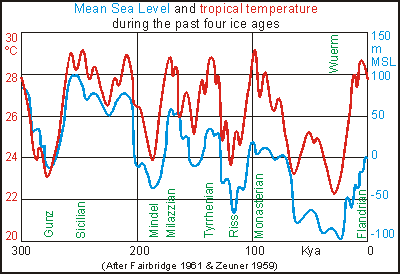 The
diagram on right shows tropical sea temperatures (red) and mean sea levels
(blue) for the past 300,000 years. Plaeontologists distinguish four ice
ages: Wuerm, Riss, Mindel and Gunz with warm interglacial periods in between
(Sicilian, Milazzian, Tyrrhenian, Monasterian and recent Flandrian). During
all of this time, Niue was located at the southern fringe of where coral
grows faster than erosion by wave action and natural dissolution of limestone
in water. Follow the red curve for all the periods extending above 26-27ºC.
During these periods, Niue grew, whereas during the inbetween periods,
Niue must have shrunk due to insufficient coral growth (the higher the
temperature, the better corals grow). Follow the blue curve, and it shows
that some 250,000 years ago, the sea level stood 100m higher. Further back
in time, it stood higher still. Thus the Mutalau Reef and lagoon may have
been formed during warm times when the sea level stood 100m higher than
today. Fossil shells show that this happened some 1 million years
ago but this date is uncertain. Niue may have formed in the Sicilian interglacial
when the sea level stood above the Mutalau Reef. The Alofi Terraces may
have formed in the Milazzian and Tyrrhenian warm interglacials (120,000
- 170,000 years ago) and another accretion may have happened some 80,000
years ago. These successive periods of accretion and erosion may have caused
discontinuities in the Alofi Terraces with alternations of weak and strong
rock, resulting in chasms seen today, explained by geologists as faults.
The
diagram on right shows tropical sea temperatures (red) and mean sea levels
(blue) for the past 300,000 years. Plaeontologists distinguish four ice
ages: Wuerm, Riss, Mindel and Gunz with warm interglacial periods in between
(Sicilian, Milazzian, Tyrrhenian, Monasterian and recent Flandrian). During
all of this time, Niue was located at the southern fringe of where coral
grows faster than erosion by wave action and natural dissolution of limestone
in water. Follow the red curve for all the periods extending above 26-27ºC.
During these periods, Niue grew, whereas during the inbetween periods,
Niue must have shrunk due to insufficient coral growth (the higher the
temperature, the better corals grow). Follow the blue curve, and it shows
that some 250,000 years ago, the sea level stood 100m higher. Further back
in time, it stood higher still. Thus the Mutalau Reef and lagoon may have
been formed during warm times when the sea level stood 100m higher than
today. Fossil shells show that this happened some 1 million years
ago but this date is uncertain. Niue may have formed in the Sicilian interglacial
when the sea level stood above the Mutalau Reef. The Alofi Terraces may
have formed in the Milazzian and Tyrrhenian warm interglacials (120,000
- 170,000 years ago) and another accretion may have happened some 80,000
years ago. These successive periods of accretion and erosion may have caused
discontinuities in the Alofi Terraces with alternations of weak and strong
rock, resulting in chasms seen today, explained by geologists as faults.
 This
diagram shows the general cross section of the shore line. From right to
left, one leaves the ancient Mutalau Lagoon of 30-40m height, crossing
the ancient Mutalau Reef of 45-75m to descend onto the Alofi Terrace of
20-27m height. Descending over one of the ridges, one comes to a steep
dropoff of 6-20m height, undercut by a wave-cut notch of several metres
high. Going down a heel of 0.5-2.5m, one arrives at the coralline flat
which is bordered by a slightly higher fringing reef. Underneath the coralline
flats extends a maze of caves, at times opening up into blow holes and
seething canyons. At about 6-12m the rubble collects onto sandy flats,
alternated by coral-clad ridges, leading down a gentle slope to 25-30m
depth where the slope becomes steeper, the deep reef with corals able to
live in diminished light, while unaffected by storm waves. There exists
a remarkable difference between the exposed SE coast and the sheltered
but hurricane-torn NW coast.
This
diagram shows the general cross section of the shore line. From right to
left, one leaves the ancient Mutalau Lagoon of 30-40m height, crossing
the ancient Mutalau Reef of 45-75m to descend onto the Alofi Terrace of
20-27m height. Descending over one of the ridges, one comes to a steep
dropoff of 6-20m height, undercut by a wave-cut notch of several metres
high. Going down a heel of 0.5-2.5m, one arrives at the coralline flat
which is bordered by a slightly higher fringing reef. Underneath the coralline
flats extends a maze of caves, at times opening up into blow holes and
seething canyons. At about 6-12m the rubble collects onto sandy flats,
alternated by coral-clad ridges, leading down a gentle slope to 25-30m
depth where the slope becomes steeper, the deep reef with corals able to
live in diminished light, while unaffected by storm waves. There exists
a remarkable difference between the exposed SE coast and the sheltered
but hurricane-torn NW coast.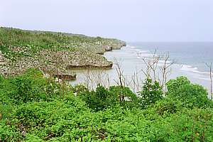 This
view, looking south from Tuapa (N of Alofi), shows the typical shape of
Niue's shoreline. From the sloping Alofi Terrace on left, ridges run into
the sea, alternated by steep valleys. Both end in a platform that extends
further out into sea before it rises into a knee-high ridge, the outer
reef. From there it drops down to 6-10m, where it descends more gradually.
This
view, looking south from Tuapa (N of Alofi), shows the typical shape of
Niue's shoreline. From the sloping Alofi Terrace on left, ridges run into
the sea, alternated by steep valleys. Both end in a platform that extends
further out into sea before it rises into a knee-high ridge, the outer
reef. From there it drops down to 6-10m, where it descends more gradually.
 Limestone
is dissolved by the small amount of carbondioxide that dissolves in water.
The air around us contains very small concentrations of carbondioxide,
only 40 molecules for every million. Those molecules that dissolve into
water, exist in equilibrium (balance) with those outside, such that the
concentration of the acid it forms, is indeed very low. But this small
amount attacks limestone rock fiercely, dissolving it into the water. In
this manner the other elements in the rock are freed up, enabling the formation
of soil where plants and soil biota (worms, bacteria, fungi) exist. Where
the infused water (with calcium in it) dries up, such as on dripstone formations,
the limestone is again laid down layer by layer, in a very hard form. Where
algae are present due to available light, such dripstones may assume wonderful
palettes of colour, such as in the Avaiki cave.
Limestone
is dissolved by the small amount of carbondioxide that dissolves in water.
The air around us contains very small concentrations of carbondioxide,
only 40 molecules for every million. Those molecules that dissolve into
water, exist in equilibrium (balance) with those outside, such that the
concentration of the acid it forms, is indeed very low. But this small
amount attacks limestone rock fiercely, dissolving it into the water. In
this manner the other elements in the rock are freed up, enabling the formation
of soil where plants and soil biota (worms, bacteria, fungi) exist. Where
the infused water (with calcium in it) dries up, such as on dripstone formations,
the limestone is again laid down layer by layer, in a very hard form. Where
algae are present due to available light, such dripstones may assume wonderful
palettes of colour, such as in the Avaiki cave.
 The
middle of the island was once the atoll's lagoon, and it is still mainly
flat today. The surface rocks of the basin are all calcarenites
and commonly contain mollusc shells. The sand is cemented on about 60%
of the area and incipient (beginning) karrenfelds have developed
leaving residual pinnacles commonly rising about 5ft above the adjacent,
flat, uncemented sand.
The
middle of the island was once the atoll's lagoon, and it is still mainly
flat today. The surface rocks of the basin are all calcarenites
and commonly contain mollusc shells. The sand is cemented on about 60%
of the area and incipient (beginning) karrenfelds have developed
leaving residual pinnacles commonly rising about 5ft above the adjacent,
flat, uncemented sand.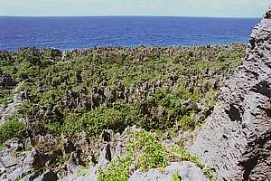 The
southern coast is attacked by the full force of the prevailing winds, and
the effect of constant spray has produced an entirely different landscape
from that in the more sheltered coastal areas. Instead of it being cliffed,
it is backed by a slope of 17-22º leading from sea level to the Alofi
Terrace. This slope is bare of vegetation and is exceedingly rough, being
a karrenfeld of crevices and razor-sharp pinnacles. Blowholes add
beauty to this desolate coastline.
The
southern coast is attacked by the full force of the prevailing winds, and
the effect of constant spray has produced an entirely different landscape
from that in the more sheltered coastal areas. Instead of it being cliffed,
it is backed by a slope of 17-22º leading from sea level to the Alofi
Terrace. This slope is bare of vegetation and is exceedingly rough, being
a karrenfeld of crevices and razor-sharp pinnacles. Blowholes add
beauty to this desolate coastline.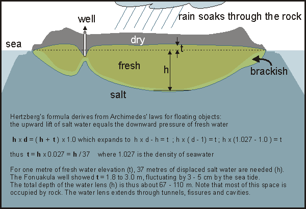
 Niue
is located south of the moist tropics but north of the dry subtropical
deserts. Warm moist air rises above the equatorial band, raining its moisture
over tropical rain forests. The dry high altitude air travels south-west
in a rotation known as the Hadley Cell. Above the subtropic high, the dry
cool air descends and warms up, becoming even dryer. From the subtropic
high the wind continues its Hadley spiral, now blowing as a south-easterly
trade wind, evaporating moisture from the sea and joining up with the tropics
again, where it deposits its load of moisture. This is why Niue experiences
long periods of trade winds blowing from the south-east.
Niue
is located south of the moist tropics but north of the dry subtropical
deserts. Warm moist air rises above the equatorial band, raining its moisture
over tropical rain forests. The dry high altitude air travels south-west
in a rotation known as the Hadley Cell. Above the subtropic high, the dry
cool air descends and warms up, becoming even dryer. From the subtropic
high the wind continues its Hadley spiral, now blowing as a south-easterly
trade wind, evaporating moisture from the sea and joining up with the tropics
again, where it deposits its load of moisture. This is why Niue experiences
long periods of trade winds blowing from the south-east.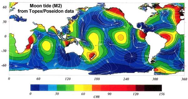