By Dr J Floor Anthoni, 1997
www.seafriends.org.nz/issues/res/gi/gidive.htm
Many divers have dived inside the Goat Island
marine reserve, and explored its many fascinating places. Unfortunately,
this information was lost, because it was never written down and published,
but here is a first record from first-hand experience. Enjoy the diving
and snorkelling in the places that fascinated them and the places nobody
knew existed. Help to protect the secret and sacred places you are going
to learn about. Share us your secrets to make this a better record.
For best printed results, set your left margin to 0.3" and
right margin to 0.2". This section contains over 190 files, about 3.5MB.
For corrections, suggestions and improvements, please
e-mail
me.
-- home -- conservation
issues -- marine reserves -- site
map -- Rev 20021210,20030110,
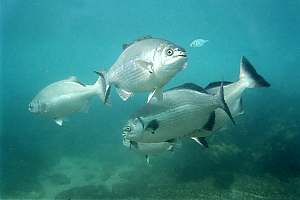
Tips for diving and snorkelling Congratulations! You are about to embark on one of the nicest pursuits
in New Zealand in one of the finest places our country has to offer. The
Goat Island Marine Reserve was established in 1977 and since that time
the fish have not only become very numerous but also very tame. Immediately
off the beach you will encounter schools of blue maomao, normally open-water
plankton feeders, vying for breadcrumbs. And not far away are numerous
snapper, trevally and the cheeky blue cod. Going further afield, the spotties,
parore, kelpfish, marblefish, red moki and crayfish are expecting you.
The further you venture from the beach, the cleaner the water becomes and
the more naturally the fishes behave. Make it a habit not to feed them
outside the beach area. Never break urchins!
If you want to learn more about free-diving, read the section
Snorkelling
with Floor Anthoni (11 pages).
Please respect the sea and its forces. This beach faces an open ocean,
and can at times become dangerous. The temperature is never comfortable
and safe for swimming without wetsuits, although February is the warmest
month. Winter temperatures are around 15ºC, but may dip to 12ºC.
Summer temperatures rise to 21º, with a shallow warm layer rising
to 23º on warm, quiet days. Divers need wetsuits in all seasons. Swimmers
can get away without, in the months January - March.
The currents are usually minimal, but they are unpredictable. Be aware
that a westerly wind sends a westerly current through the channel, which
may, at times be uncomfortable for divers. Swell may arrive unpredictably
from distant northern sources, but more likely the waves are caused by
winds from W to N to E, whereas SW to S to SE winds are best for calm seas.
The currents in the channel are never dangerous but they could be a
nuisance during spring tides. Swim close to the rocks or the bottom for
minimum currents. If necessary, use your hands to pull yourself along.
Remember that you can get out of the water in many places. Goat Island
forms a barrier to waves and swell and you can usually swim or dive in
its shelter. But avoid the white water areas where the water runs swiftly
over submerged rocks. Here you could easily be swept into a most uncomfortable
situation. Should you need to get out on a rock, take your time and find
the most sheltered and accessible spot. Remember that there's always a
better spot to be found. Look where the urchins are and where to put your
foot. Take one fin off. Let the waves do the work. Put your foot down firmly
and stand upright in one motion. Let the waves wash back past you before
clambering up the rock. NEVER crawl out of the water on your knees! The
water has too much grip on you this way.
There are no dangerous animals to be afraid of. Sharks have never caused
a problem, and they are much rarer than dolphins. At times there can be
jellyfish in the water. Some sting, some don't. When stung, treat the rash
with vinegar. The rocks can be your biggest enemy, where waves wash over
them. Sharp creatures on these rocks (oysters, barnacles, tube worms) can
rip your suit and skin.
What to do and what not to do Here are some DOs and DON'Ts to help you:
Have patience with the suits, zips, straps and flipper insteps; They rip
easily. Help your kids.
Don't walk on the fins. At least, walk backward.
Don't let your regulator, snorkel or mask touch the sand.
Don't lie in the wave wash at the beach with dive gear on.
Before wetting your mask, spit into it thoroughly and rub the saliva all
over the inside windows. Then rinse with one swoop only. Wet your face
to cool it and to reduce perspiration.
Keep your tongue up as if saying T or D, when breathing, to avoid drops
of water shooting into your wind pipe.
To clear your snorkel, blow hard with a 'D' sound. The best way is to gently
blow it empty while under water and at the same time pushing it up through
the surface.
To clear the water out of your mask, look UP. Push the glass onto your
face above your forehead. Blow gently into the mask. The water will run
out.
Before going far, make sure you have the right amount of weight and that
you feel comfortable.
Don't get too cold. Think of the return swim. Make sure you have a warm
wetsuit.
Go where the waves are minimal.
Don't crawl over the sharp rocks or sit on them because that could wreck
a wetsuit instantaneously.
The right weight Take time to make sure you have the right amount of lead on your weightbelt.
Do as follows:
Go into chest-high water and try to float in an upright position. You may
have to let the water run into your wetsuit and bubbles out of your wetsuit.
Breathe in as far as you can. You must now float comfortably with your
eyes and your nose out of the water.
Breathe out completely. Your eyes must go under water but you may not sink.
Adjust your weight until you can do the above comfortably.
Pull your weightbelt up over your chest so you can float horizontally,
head down, while breathing through your snorkel. You must float comfortably.
It is dangerous if you sink in this position. Adjust your weight belt further.
Snorkelling down A good snorkeldiver does not fight the water or the waves. He goes
down effortlessly and balances himself in the water by blowing excess air
out. Here is how you go down with a 'duck-dive':
Don't try to swim down but bring your legs up high out of the water. First
jack-knife as if wanting to touch your knees; then stretch out. Your legs
will rise out of the water. The weight of your legs (one fifth of your
body height), pushes you down. At the same time, make one swimming movement
with your arms.
Hold a plant or the rocks so that you won't float up again. Now let enough
air out so you can let go of the rock without floating up. Make small swimming
movements to move around. Better still, pull yourself along the rocks and
kelps with your hands.
To avoid ear pain, hold your nose and close it. Then blow air (like a mild
sneeze) until you hear your ears 'pop'. Do this before they start to hurt.
Staying down In order to be able to stay down for a long time:
you must have a warm suit so you won't lose energy through shivering.
you must feel comfortable and not be afraid. There's nothing to fear.
you must have the right weight on your weightbelt.
you must not fight the water.
take five deep breaths before going down.
you must remember that it gets much better after the first few horrible
attempts.
grab hold of the rock or a seaweed, in order to stay at depth and not waste
energy fighting to go down
let enough air out of your lungs to balance yourself, then swim slowly
and confidently along
ascend without panic. Relax.
Diving from a beach Divers, please note that beach diving requires some extra skills, and
invites for making new mistakes. It is much more challenging than hopping
over the side of a boat.
you have to carry your gear from the parking lot, over loose sand into
waves. Are you fit enough? Does your buddy need help? Is there any gear
that can break?
you need a warm, protective wetsuit. Are you familiar with heavy weight
belts and the skills to neutralise your buoyancy?
make sure you are kitted up BEFORE going into the water. Only mask and
fins are still to be done.
in the water, walk backward and hold your buddy firmly by the shoulder.
In this manner the two of you become a single four-footed animal, reducing
the risk of falling and stumbling considerably. Once you are down, it is
hard to get up again.
NEVER crawl on hands and feet in or out of the water. Your regulators and
BCD inflator will fill up with sand and become dangerous to use. They will
require an expensive overhaul afterwards!
sand is your equipment's worst enemy. Keep regulators and BCDs off the
sand at all times!
entering the water is fatiguing for many. Before swimming out or diving
under, lie still in the water to regain you breath.
in order to know where you are and not to swim in circles, surface regularly.
Note the movement of the water and the ripples in the sand, and use these
to orientate yourself. If you have a compass, try to use it.
in the channel, stop to check the current. It is better to swim upstream
when going out, and to return with the movement of the current.
plan your return trip under water, because many divers feel uncomfortable
swimming at the surface.
give big waves a miss. They can be dangerous, and damaging to health and
equipment. They also foul the water. Learn to duck under an oncoming wave,
when going out.
in case of currents, swim to a side or to the bottom where they are less
strong. Use your hands to pull yourself forward, rather than by kicking.
Don't overfatigue yourself. Rest if necessary.
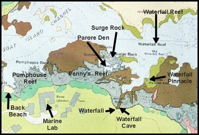
Maps and placenames In the course of time, people have given various places their names.
Read this section to familiarise yourself with the placenames and what
is interesting about them. The detailed maps have been derived from the
overview
map.
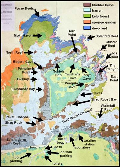
An
overview The overview map of the area around Goat Island shows most of the important
placenames. Click on the map for a larger version.
Visitors arrive from the Goat island Road, at bottom left, park their cars
on the top parking which has many levels. They then walk to the beach entrance,
where an unloading zone (bottom parking) can be used to unload heavy equipment.
The Department of Conservation (DoC) has built primitive long-drop
toilets, because of the difficulty of discharging sewage in this area.
There is no running fresh water. Take your rubbish away with you, because
rubbish bins are inadequate for busy days. Should you need better facilities,
do not hesitate to visit Seafriends at the top of the Goat Island Rd.
The Goat Island Road continues across the little stream to the Marine
Laboratory of the University of Auckland. A public walking track leads
from here over the rugged coast eastward, but does not reach Cape Rodney,
nor does it loop around. One has to track it back to its beginning, but
it is well worth doing.
Most diving and snorkelling happens in the vicinity of the main beach,
as discussed in detail below, but intrepid explorers can go all the way
around the island, provided they take sensible precautions, as explained
below.
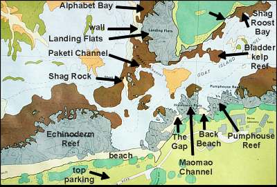
The
beach area The beach area radiating out from the only access point by the creek,
is by far the most visited. People usually enter the water from the beach,
going either west, north or east. Make sure to avoid the rocks on both
sides of the beach, while entering the water. A good entry point is The
Gap, some 50m to the right of the beach. It has a sandy bottom and
it becomes deep more quickly than the water in front of the beach. It is
prefered by divers, also because it has no boulders to stub one's feet
on. A little further still, lies Back Beach, hidden around a corner
of the cliff. From here one can swim into Maomao Channel, a narrow
gap in the rocky
Hormosira Flats platform, where people feed the
fishes. Blue Maomao abound here. (Hormosira= necklace weed)
Shag Rock breaks the monotony of the area, offering hiding places
for fish and crayfish, while providing more shelter to the Paketi Channel
(Paketi= Spotty). It is not surprising that this area is naturally
rich in fish (as opposed to the artificially attracted begging fish schools
nearer the beach). You will find sandy patches visited by fishes to be
cleaned by young trevally. Hiding under the boulders, you will find crayfish
and the nocturnal bigeyes. This is a place visited by crayfish when they
are due to moult. Look for the secretive butterfish and banded wrasse in
the stalked kelp, while pipers are skimming the surface.
North of this shallow channel, lies a 6m deep sandy spot, home of large
snappers. Along the island, stretches a vertical wall, undercut
by shallow caves, home for cryptic fishes (various species of triplefin,
dwarf scorpionfish) and crayfish. Going further, you will enter Alphabet
Bay, a very interesting shallow bladderkelp area, crossed by deep cracks
where often stingrays are found resting. Alphabet Bay is named after
the alphabet letters A-E painted on Goat Island's cliff. These were used
to identify research sites. At the point of the arrow is a rock with a
crayfish city underneath. See if you can find it.
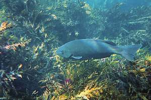
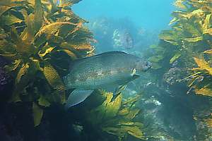
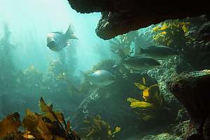
f007727:
rare and large silver drummer have congregated above a sandy patch to get
cleaned by a small trevally, just visible facing the highest fish. Notice
how the clients change colour for signalling their readiness.
f014808: butterfish announce their presence by their bite
holes left in the kelp leaves. They fold a leaf double inside their mouths,
and bite half a circle out. In this manner, the leaf does not easily rip
during storms, which would otherwise waste their food source.
f007733: butterfish are secretive, shy and sneaky. They live
underneath the stalked kelp, which is both shelter and a source of food
for them. All born female, a butterfish may change sex to become male later
in life. This one is about to do so.
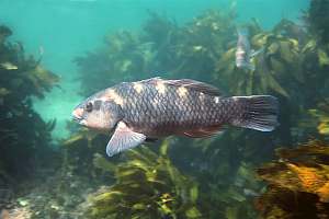
f008507: the banded wrasse is one of NZ's most sturdy wrasses,
living happily in wave-washed environments. Like the butterfish, it maintains
a harem of females inside a large territory.
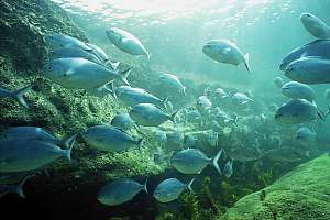
At its narrowest point, Goat Island Channel is also at its most
shallow, resulting in a noticeable current pushing through this bottleneck.
One can find young blue maomao and sweep facing the current, as they catch
zoo plankton. But the sea bottom is monotonous and sandy. Look for the
odd eagle ray burrowed here. The situation becomes suddenly interesting
around and above Bladderkelp Reef, where grazing fish like parore,
silver drummer and marblefish abound. Behind this reef extends a deep sandy
area, bounded by another interesting snorkel spot near the top right corner
of the map, Shag Roost Bay. It is named after the shags roosting
here in the high-rise pohutukawa trees. Duck behind the shallow rocks at
the point of the unlabelled arrow to find large crayfish in shallow water.
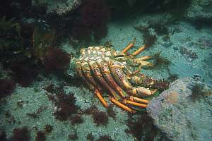
f003505: discarded crayfish moults like this one are just
the empty skins in which crayfish and other crustaceans live. In order
to be able to grow, they shed the old skin and grow a new one.
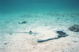
f002311: an eagle ray lies half-burrowed on the sand. They
used to be common in the Goat island Channel, but have been scared off
because of people's inconsiderate behaviour.
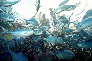
f022018: blue maomao keep a watchful eye on the people above
water, who are about to feed them.
f022024: Blue Maomao Channel is the hang-out of a small school
of blue maomao. They have been attracted by the food people bring.
Going
east towards Waterfall Reef The Marine Laboratory is located at the foot of a ridge. Behind it
runs a gully, which is the catchment area for a small stream gushing over
the edge of the cliff. It is called Waterfall. Even in mid summer,
the waterfall trickles along. Underneath it, the rocks have been cut deep
by a steep gully, ending in a deep cave with a shingle bottom above water.
This Waterfall Cave can be explored when the water in the gully
is calm enough. Climbing up the steep shingle can be tiresome.
Walk over the rock flats to Back Beach, and start your exploration
from here.
The outstanding feature of Pumphouse Reef is a white cubicle
made of concrete, which houses the pumps for the saltwater circulation
systems of the Laboratory. At the foot of this reef, the rocks offer safe
shelter for large crayfish, tucked away in singles and doubles behind a
barrier of lower reefs. Further out from Pumphouse Reef the topography
becomes more pronounced, with canyons.
Penny's Reef continues on from Pumphouse Reef towards
Surge
Rock. It was named after Penny ??? ???. In between the two lies a sheltered
bowl of water, confiscated by the local Parore for their sleeping hangout.
Even when the water surges heavily over Surge Rock,
Parore Den
is tranquil. Here you can see the Parore changing colour to fall asleep,
often attended to by triplefins cleaning their skins from parasites. Among
the boulders, large crayfish can be admired. This is also a place where
young crayfish can be found, at times smaller than a finger.
Waterfall Reef is a large barren area, sloping down gently to
the sand at 15m depth. Here a fringe of stalked kelp can be found, sometimes
buried by the sand. Because of its ease of acces (from Waterfall), this
has always been a favourite study area for students of the Marine Lab.
They distinguish Outer-, Mid- and Inner-Waterfall
Reef. A pinnacle rises to the surface and could be a navigation hazard
at low tide. Between the pinnacle and the shore, the topology is varied
and interesting, with both wild water and shelter, inviting for a surprising
variety of fish. This extends all the way to the end of the map, marked
by Ray Rock after which the seascape changes to 10m deep water with
gravel and sand. Around the corner, marked by pink on the map, is a gravel
beach at the foot of a number of caves where blue penguin can be found
nesting in October-December.
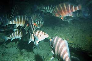
f000922: This is a side chamber of the parore sleeping den,
chosen because of its tranquility and the many bunks it provides. (continued
on right) >>
f001820: a small group of Parore comes home for a rest after
having foraged for breakfast. One halts, discovering the photographer.
Spending time in this area before the sun sets, is quite rewarding.
>>At night, every ledge is occupied by a sleeping Parore.
They fight over the prime bunks, and return to their own each night. In
this photo, a parore returning home (bottom), one inspecting the photographer
(top) and at least six visible resting.
Leaving Parore Den on its eastern side, through a narrow gap and around
Surge Rock, gives you a chance to explore a varied rocky bottom to 15m
depth, with varied drop-offs and boulders, housing a sizable quantity of
crayfish in small numbers at a time. In the good times, this round trip
would bring you face to face with over 70 crayfish.
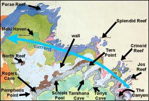
Diving
the outside Almost all places shown on this map are exposed to the open ocean.
For snorkeldivers venturing to explore the outside, it may mean having
to cope with froth-laden surface waters, unpleasant waves, cold and fatigue.
From the beach to Pempheris Point (Pempheris adspersa= bigeye),
it is but one third the way around the island, a good moment to reflect
on the two-thirds still to go. At Tern Point (we call it Half-way
Point), you are half-way, the point of no return, and you might as
well push on. Tern Point is named after the hundreds of terns (and
red-bill gulls and black back gulls) who came to nest here from October
to December, in the seventies and eighties. However, they have not come
back since the nineties.
The large caves invite for exploration, but don't be disappointed if
you don't succeed. You will need very calm water without easterly swell,
and you need to bring a powerful torch, for the Tamihana Cave is
very deep, with a wet beach at its end and a cocktail shaker in between.
Very few have made it there. Tonys Cave (named after Tony Ayling)
is much shallower, and the area in front of it, also calmer.
The Canyon is an interesting but barren feature before reaching
East
Point (also called Goat Island Point). In theory at least, snorkellers
should be able to visit North Reef, a serious navigation hazard
which almost bares itself at spring low tide. But from the shore, it is
almost impossible to find, reason why spearfishermen in the sixties left
it alone, and with it Moki Haven (often mis-spelled as Moki Heaven)
where the last big moki congregated.
In order to dive in this area, a boat is more than just welcome, because
it takes a good 20 minutes of snorkelling with all your gear on, to reach
Pempheris
Point, where the fun begins. Pempheris Point is interesting
because it marks the boundary between the inside and the outside (the fish
think so too!). Moor your boat on the barren rock flats of Alphabet
Bay, near D-Buoy, and swim towards the point. A large rock leaves
a narrow, seething gap, leading to a semi-sheltered bowl with a steep wall
east. This wall has shelves running along, stocked like a supermarket,
with species of all kind. Bring a torch to see them all. Do a round loop
westward, then back, over the ridge to see many crayfish, butterfish and
more. The sheltered bowl was once the breeding ground of demoiselles, but
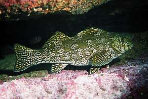
they disappeared in the nineties. However, the biggest and shiest snapper
of the reserve are often found here before they dare to move closer to
the beach. Here you also encounter a small moki hole. A sizeable spotted
black grouper also lived here.
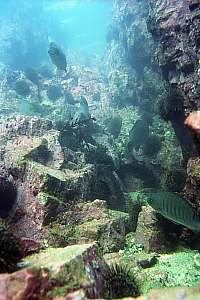
f000718: a parore (Girella tricuspidata) in dark olive
suit grazes the red fluffy algae from the tough flapjack bladderkelp.
f016906: a shy marblefish (Aplodactylus arctidens)
has also taken refuge on the shelves, displaying itself as if it were a
desirable grocery on a supermarket shelf.
f016913: a small moki hole can be found where the grocery
shelves end. These moki (Cheilodactylus spectabilis) are mature,
but not old. Aged about seven years, they will gradually lose their stripes
to become mottled brown, living to a ripe 40 years.
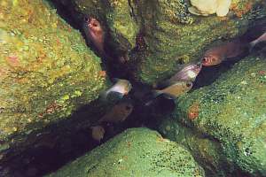
f012329: in the cracks and over the shelves, you can find
the very common bigeye (Pempheris adspersa). These fish hide by
day but feed on plankton by night. They are good at intercepting prey,
rather than giving chase. With jerky movements they jerk forward, to come
to a complete halt for a few seconds, allowing themselves to see what moves
in the water. They react fast, and they are hard to catch.
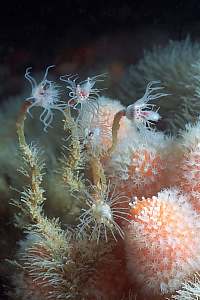
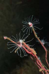
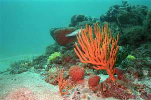
f032531: the Shelves offer protection to fragile sessile life like
these orange deadman's fingers (Alcyonaria sp.) and tubular hydroids
(Tubularia sp.).
f032535: close-up of Tubularia. Most hydroids
cannot retract their polyps, but this species lives inside a flexible tube,
which protects its main parts, but not what sticks outside.
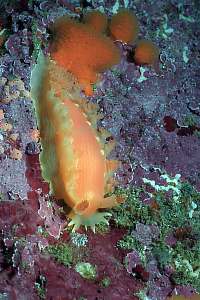
f032526: the Tritonia nudibranch (Tritonia incerta)
is never far away from the deadmans fingers because it feeds on them.
Rogers Cave is the next dive of interest. Moor the boat on the shallow
flats near the cave. These flats, although barren with here and there a
seaweed, are interesting. You find an unusual number of sand octopus, crayfish
and large seven-armed stars. The cave itself is submerged at high tide
(the best time to visit), but in between, it becomes a kind of blow hole,
compressing the air inside with a loud bang. At the same moment it also
compresses the air in your lungs, which is a remarkable sensation, to say
the least. Go further into the cave, and it becomes quiet. You can breathe
from the air in the air bubbles. In front of the cave, the water moves
to and fro and is home to schools of silver drummer and blue maomao. Interestingly,
a few resident black angelfish (Parma alboscapularis) are also found
here. The shallows east of the cave are interesting and varied, but you'll
need calm water for your exploration.
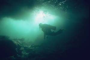
f013815: a diver hangs motionless in Rogers Cave, experiencing
the sensation of sudden air compression.
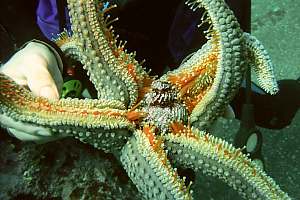
f013822: a large seven-armed star (Astrostole scabra)
shows what it has caught for a meal, a Cooks turban shell (Cookia sulcata).
From Rogers Cave, move west to a nearly surfacing rock, covered in flapjack
bladderwrack, home to grazers such as parore, silver drummer and kelpfish.
Over the ridge you will enter the sheltered bowl with the supermarket shelves.
Going north, extends a gently sloping platform which ends where the ridge
of North Reef begins. Heavy swell breaks over this reef, leaving the area
between it and Goat Island relatively sheltered. Over North Reef begins
the current, which can run quite fast over its ridge. Many fish of various
species, particularly snapper, hang out in this area. It is a good spot
for a night dive by boat
North Reef to Moki Haven is a fantastic dive. Moor your
boat near North Reef on the barren rocks, and descend westward steeply
to the sand where an enchanting landscape of sponges is found. On your
left the sand-covered sponge gardens, and on your right the steep sided
deep reef at the foot of the kelp forest. Follow along the sand, eastward.
In a shallow cave with a sandy bottom, you'll encounter one of the densest
crayfish cities inside the reserve. Follow along the sand until a ridge
in the kelp forest comes down. Follow this ridge up to a depression, and
notice the many moki there. Try to find a small cave, and you've found
Moki
Haven. This cave is at times (always?) filled to the brim with some
70 large and small red moki. You can enter it with a torch, towards the
dark rear, obscured by so many fish. Follow the ridge south to SW towards
North
Reef, your starting point. It is a long, deep dive (20m). Watch out
for currents over North Reef, particularly on the outgoing tide.
Another nice dive leads from the wall near Schiels Pool (named
after Dave Schiel) north towards the deep reef. Moor the boat on the shallow
flats west of the wall and swim along this wall to the deep, perhaps to
Porae
Reef, then back again.
Diving Tamihana Cave can be disappointing because the canyon
leading into it, is abraded by tonnes of shingle, deposited in front of
it. But you'll see some nice drop-offs with remarkable stands of tall stalked
kelp and large sea urchins. The deep reef becomes poorer due to scouring
and strong wave action at depth, in front of the caves. Crinoid Reef
was named after the featherstars (Crinoids) found here, but they
have gone long since.
Jos Reef was named after the Lab technician
Jo Evans.
Diving East Point You can moor your boat over the 20m deep sand, and immediately descend
to the bottom, to follow the bottom fringe of the kelp forest, with its
many sponges. Going eastward, the forest margin bends south, where often
schools of young snapper are found. Schools of blue maomao, trevally, jack
mackerel and kahawai come down from the blue to visit you. Your dive continues
along a pebbly bottom clearly showing the digging activity of the
giant heart urchin (Brissus gigas). From there southward, the environment
becomes monotonous, all the way to the Goat Island Channel. But
right around East Point, you will find a few steep-walled canyons,
with another crayfish city near the bottom.
An interesting feature of the eastern side of Goat Island is Penguin
Cave, a large and deep cave with a dry beach inside. It is named after
a few blue penguins (fairy penguins) nesting here from October to December.
You'll need a torch to explore this cave, but it is usually safe to enter.
In front of the cave exists relative shelter over a sandy patch, enough
room to moor a small boat, and you can find young crayfish amongst the
boulders.
Other dive sites Favourite dive sites are often chosen on the basis of a feature
which is easy to find, a hotspot of biodiversity, a convenient place to
anchor, shelter and so on. But the entire area of the marine reserve is
divable and interesting. In this section we'll describe a few of the places
outside the central area.
Lovers' Leap Lovers' Leap is a steep cliff by Lookout Point at the
end of the Coastal Walkway. Underneath it extends an area which
is interesting for snorkelling, due to its scattered boulders and passage
ways. From the Lookout Point, one can clamber down to the sea, and
this was indeed one of the prime snapper fishing spots which the locals
had to sacrifice in lieu of the marine reserve. To the east, one can snorkel
the capricious topology of that area. To the west, one could walk along
the water's edge, all the way to Waterfall and back to the Coastal
Walkway. However, in the mid-1980s, two critical rock ledges collapsed,
and this is no longer possible.
Tabletop Rock Tabletop Rock is a large, flat rock with a sloping flat in front
and canyons behind it. One can anchor one's boat in front of it on the
pebbly bottom. A dive circling around Tabletop Rock, is most
interesting for its variety, but you'll need a reasonably calm sea. For
ease of navigating, go around it in a clockwise manner, and go slowly because
much interesting life is hidden from view. On its east side, there is a
shallow, narrow gap to go through. In the canyons to the west, you'll find
large crayfish, and many fish sheltering inside deep crevices where Tabletop
Rock is split. One or two crayfish cities can be found here too. Visit
its shallow sloping flat with bladder kelps, to observe parore, marblefish
and silver drummer feeding. From the pebble basin, a valley leads to the
deep sand at 18m depth. Study the steep rock walls for their variety in
attached life forms.
Smugglers Cove Smugglers Cove or Motu Ruru Cove can be very wild at
times, because waves are compressed within its tapering funnel. It is littered
with broken rock, home to a great variety of triplefins.
Rodney Cove Rodney Cove is flanked by two rocky outcrops, and is not immediately
evident when passing by boat. However, it forms a sizable pool of shelter
for many conditions, except for northerly swell. Use this cove to rest
from a dive. This pool is also excellent for beginning divers as it slopes
gently to 10m depth at its entrance. But for the naturalist, Rodney Cove
is a treasure trove of variety, which includes sponges in shallow water.
At its entrance, going east, one finds a sentinel rock with a passage.
Lots of semi-pelagic fish.
Floors Reefs I have taken the liberty of naming Floors Reef after myself,
since I also discovered it first. It consists of a low reef and a pinnacle
rising to 14m depth from a 24m deep sea bottom, and separated by some 10m
of sand with a boulder here and there. Floors Reef lies smack in
the middle of a strong current, bending around Cape Rodney. So take all
necessary precautions:
The best time is to dive it during neap tides when currents are least strong.
The low tide makes the sea bottom over 2m shallower, thereby extending
your bottom time noticeably. Note that the current does not necessarily
stop at the low tide for Auckland, but often an hour before low and an
hour after high tide.
Finding the reef is tricky, even when GPS co-ordinates are accurately known.
You need a depth finder as well.
Let enough anchor warp out to hold in the current. 40m at least.
Use a Jezus Line, a buoyed floating rope of at least 40m, trailing
in the current behind the boat. This gives you a much better chance of
swimming back to the boat.
Make sure you WILL find the anchor warp under water, at the end of the
dive, because decompressing in mid water while the current transports you
over a vast distance, is not an option. Be aware of every change in direction
you take under water, and use your compass frequently. For beginning divers:
aborting a dive unplanned, is not an option! Poor visibility increases
risk! Decompression dives are not an option.
Check bottom time and tank contents frequently. Stay together. Stay with
the person who knows the reef.
If you have GPS, navigate to S 36º16.455' x E 174º49.189' . Failing
that, start from the middle of the entrance to Rodney Cove S 36º16.630'
x E 174º49.122' and steer exactly 0.0º magnetic. After 0.14 nautical
miles, you should be on top of it. Use your depth finder to confirm.
Floors Reef is worth the effort because it is perhaps the best
dive inside the reserve. When I discovered it in July 1992, before the
kelp die-off of 1993/94, it was like Noah's Ark, home to a few of just
about every species in this part of the sea. It was a hot spot, because:
the currents are strong, and they bring planktonic food for a large variety
of filterfeeders and semi-pelagic fish and a shellfish bed of dog cockles
and burrowing giant hearturchins. Pelagic schools of jack mackerel and
trevally are common.
currents and waves have a cleansing effect on sessile organisms like sponges,
keeping them in good health.
it provides a place to sleep for blue maomao, sweep, butterfly perch and
scarlet wrasse.
the water is the clearest around, inviting demoiselles to breed.
there is a steep wall, too dark for plant growth, inviting sessile filterfeeders
and brachiopods.
a small cave provides shelter to the nightshift animals, various species
of cod, red moki and a huge conger eel.
cracks in the rocks are large enough to shelter over 200 crayfish, some
of which the biggest ever seen.
the healthy sandy habitat invites many goatfish.
the top of the reef is light enough for plant life, providing enough food
for a family of butterfish.
it provides prey for john dory and kingfish.
it provides shelter to visitors like giant boarfish and tarakihi.
the pinnacle acts like an oasis, being separated from the coastal reefs
by a wide margin of sand.
The cave at the south end of the wall, is about 5m deep and 1.5m high at
its entrance. You need a good torch, and move forward on your fingers,
due to the sediment inside. Don't use your fins. Don't challenge the conger
inside- just admire him.
Floors Reef suffered three major set-backs. In November 1992, a dense
plankton bloom killed all the kelp. It took until 1998 before it had recovered
sufficiently. In 1995 the news of this discovery leaked out, and within
a week all crayfish had been poached. In the 90s the amount of sediment
reaching the sea, increased considerably, resulting in an overload of silt
in crevices and inside the cave.
I hope that you will respect this unique place, and allow it to recover
fully, including its crayfish population. Back in 1992 two spiny crayfish
were so big that they had no fear of me. They allowed me to close thumb-to-forefinger
around their paws, and I was unable to make my fingers touch! One day,
I hope, a dive club may rise to the challenge of mapping these two reefs.
f004812: a community of large and healthy sponges can be
found all around Floor's Reef and wherever rocks surface above the sand
in the area around the reefs.
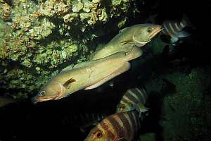
f017107: large southern bastard cod (Pseudophycis barbata)
and red moki (Cheilodactylus spectabile) milling around at the entrance
to the small cave at Floor's Reef. Large crayfish can be found inside.
Above the cave a yellow variation of lamp shell or brachiopod.
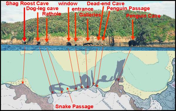
Cave
exploration On the west side of Goat Island extends an extensive system of interconnecting
caves, worthy of exploration by the not so faint-hearted. The combined
map and photo on right shows the extent of the cave system, with its names.
Click on the image for a larger version. Please
note that this map has been drawn from memory and is not precise. One day
some dive club may rise to the challenge to map these caverns more expertly.
Exploring these caves and their passages is not dangerous, provided that
you take the necessary precautions.
Make sure that someone knows where you are.
Choose a calm day. Waves, particularly swell, increase risk of wounding
yourself, considerably.
Provide each member of the group with a waterproof torch.
Don't take unnecessary risks.
The trip is risky or impossible for people who are overweight, because
they are more likely to stumble and fall, and won't fit through some of
the passages.
Wear a wetsuit to protect your skin from abrading with the rocks and wear
hard-soled booties because oysters, barnacles and tubeworms are present,
and some rocks are sharp. Don't walk on your flippers.
Remember that the start of your exploration is a long swim away from the
beach, and you have to swim all the way back again. So protect yourself
adequately against the cold.
Update April 2014 Sadly, after some storms, vast amounts of pebbles were washed into
various caves, thereby obliterating some passages like the rat hole
ans snake passage. and almost the Penguin Passage. Because
the water level is important, it is suggested to do your exploration during
a neap low tide with hardly any swell. Water clarity is not important
but helps somewhat.
Begin your journey in Dog-leg Cave, the first cave which has
an entrance at water level. By contrast, Shagroost Cave starts well
above the high tide and is a dead end. Dog-leg Cave has a squarish,
deep entrance, but almost invisibly turns sharply right to a wide but low
cavern. During high tide, the ceiling of this cavern is submerged, while
waves compress and spout air ominously. Choose your timing at mid tide
or slightly later, because this allows you to swim most of the way. At
the end of the cavern, light appears and a narrow slit leads you to the
Rathole where you can exit. Note that this is difficult or impossible
for overweight people.
Dog-leg Cave has a hidden passage back
from the Rathole, which widens and then narrows considerably. However,
this narrow Snake Passage widens towards its sandy bottom, allowing
you to snorkel through at mid tide and crawl (slither) through it at low
tide. The Snake Passage widens just before the Window in
the Galleries Caves.
The Galleries Caves can be entered from
their main entrance. The other entrances have been blocked by boulders,
which can be clambered over. Once inside, the Galleries appear much
larger than expected, complete with a pebbly beach at their deepest end.You'll
find young crayfish and bigeyes in the dark recesses.Also mauve and lemon
jewel anemone mats on vertical walls. Agile crabs fleeing in all directions.
To reach Dead-end Cave, you have
to clamber over one or two rocks. It is a mysterious, almost straight tunnel,
ending in total darkness. At mid to high tide, you can float all the way
to the back inside this tunnel. At its entrance, you'll find the largest
cats-eye snails in the reserve. Leave them there.
Immediately to the right of this tunnel starts
a most interesting connection to the impressive and deep Penguin Cave.
Penguin
Passage bends around, so that its end cannot be seen from either entrance.
Inside the tunnel, which is tall enough to walk through, caverns branch
off to the north. Turn left into Penguin Cave and walk up its sandy
beach towards the back. Here one can find the nesting places of two pairs
of blue penguin or fairy penguin (October to December). Leave them alone,
because they are protected. In very good years for this sea bird, three
pairs may be found nesting here The smell of ammonia from their droppings
gives them away. Find your way out again through the cave's main entrance.
Night diving Snorkelling the Goat Island Channel by night is an exciting
and rewarding experience. It allows you to observe the 'night shift', and
how fish find their sleeping places. You require calm and clear water so
that your powerful torch can show you the bottom 2-3m away. Seafriends
hires some very bright ones. Experienced freedivers will take the torch
under water as they swim over the bottom.
You can start out from the main beach, but a rewarding place is Back
Beach, from where you can swim around Pumphouse Reef where large
crayfish start their evening walk. Wherever you go, something unexpected
may show up. By night all colours are more vivid, and previously camouflaged
animals suddenly stand out. You will meet crayfish fossicking in the open,
large conger eels, scores of bigeyes and slender roughies, and you may
bump into pipers, confused by the light. Broad squid come to shore to lay
their eggs, and goatfish are resting in their most brilliant colours. Blue
maomao change colour and hide under the kelp. Many wrasses such as spotties
and banded wrasse have dug themselves in under coarse sand. The butterfish
is a spectacle to behold, sleeping under the kelp canopy.
To prepare your night snorkeldive, bring a gas or oil lamp as an orientation
point on a prominent rock, where you can also get in and out of the water.
Your torch must be waterproof and pressure proof, as used for diving, and
it must be bright. The ideal is about 20 Watt (quartz-halogen), but 50
Watt is preferable when you need to share the light between the two of
you. Make sure someone knows where you are, or waits for you on the beach.
Stay together in the water.
Several places can be dived by night, but you must have a boat with
full navigational lights and the knowhow to get back to Leigh Harbour in
a mist. The following night dives are recommended: around D-Buoy,
around
Rogers Cave, in front of Penguin Cave, and around
Tabletop
Rock.
 An
overview
An
overview
 The
beach area
The
beach area
 f007727:
rare and large silver drummer have congregated above a sandy patch to get
cleaned by a small trevally, just visible facing the highest fish. Notice
how the clients change colour for signalling their readiness.
f007727:
rare and large silver drummer have congregated above a sandy patch to get
cleaned by a small trevally, just visible facing the highest fish. Notice
how the clients change colour for signalling their readiness.
 Going
east towards Waterfall Reef
Going
east towards Waterfall Reef
 Diving
the outside
Diving
the outside