Common
soils of the world Soil
formation depends on parent material, climate (temperature and moisture)
and biotic factors (mainly acidity, soil moisture content and drainage).
Since the minerals and elements that make up the parent material are well
mixed over the planet, the main groups of soil follow the main habitat
types of the world.
Here are the main soil orders,
in alphabetical sequence.
Alfisol: soils with clay-enriched
subsoils. Mineral soil, relatively low in organic matter, high base saturation.
Clay content increases with depth to an illuvial horizon of silicate clays
(argillic horizon), which restricts soil depth and root penetration, resulting
in poor cropyields. Soils are sensitive to crusting. Moisture is adequate
to mature a crop in most years. Mostly derived from granites, gneisses
and schists but occasionally from sandstone, mica, quartzite and shale.
Andisol: volcanic soils
of tuff and ash.
Aridisol: soils of deserts
and semi-arid regions, and related saline or alkaline soils. Mineral soil,
relatively low in organic matter. Inadequate moisture to mature a crop
without irrigation in most years. some pedogenic horizons.
Entisol: soils without
layering, except after ploughing. Mineral soil with weak or no pedogenic
horizons. No deep, wide cracks in most years.
Histosol: bog-type soils.
Organic in more than half of the upper 80 cm.
Inceptisol: very young
soils with weakly developed soil layers, and not much leaching or mineral
alteration. Mineral soil with some pedogenic horizons and some weatherable
materials. Enough moisture available to mature a crop in most years. No
horizon of illuvial clays. Relatively low in either organic matter or base
saturation, or in both.
Mollisol: grassland soils,
mostly rich in calcium; also forest soils developed on calcium-rich parent
materials. They are characterised by a thick surface layer, rich in organic
material. Mineral soil with thick dark surface horizon, relatively rich
in organic matter. High base saturation throughout. No deep, wide cracks
in most years.
Oxisol: soils that are
more weathered than the ultisols, including most laterites. Mineral soil
without weatherable materials. Inactive clays. No illuvial horizon of silicate
clays.
Spodosol: soils with
a light, ashy gray A horizon, and a B horizon containing inorganic matter
and clay leached from the A horizon. Mineral soil with an illuvial horizon
of amorphous alumina and organic matter, with or without amorphous iron.
Ultisol: soils similar
to alfisols, but with weathering more advanced. They include some lateritic
(highly leached) soils. Mineral soil with and illuvial horizon of silicate
clays. Low in base saturation. Moisture adequate to mature a crop in most
years.
Vertisol: soils with
upper layers mixed or inverted because they contain expandable clays (that
swell when wet and crack when dry). Clayey soils forming deep, wide cracks
at some time in most years.
The following table shows where
the main soil orders in the world are found. Numbers are millions of hectares.
(Various sources, from B A Stewart et al: Sustaining the world base of
an expanding world agriculture, in Lal & Pierce: Soil management for
sustainability, 1991). Of the total land area of 13,000 Mha, 8,800 Mha
are productive land, forest or farmed.
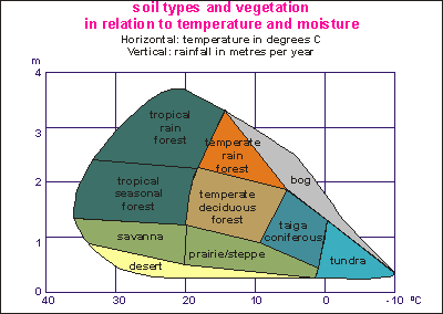
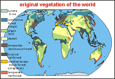
The
world's ecosystems depend primarily on their plants, which in turn depend
mainly on climate. Soil formation depends on the same climatic factors
as these, and on the acids produced by the plants. It is not surprising
then, that the main soil orders of the world follow the world's main ecosystems.
The diagram above shows the vegetation type (and ecosystem) as a function
of both temperature and rainfall. The boundaries between the various ecosystems
curve downward, going from left to right (hot to cold). This is because
more moisture is needed in warm climates, in order to offset their high
evaporation losses. So, an amount of 1m rainfall in the tropics is barely
enough for dry savanna grassland, but in the polar regions will lead to
the formation of bogs. Important is not the amount of rainfall but whether
it is more or less than natural evaporation. Below follow the soil characteristics,
going from cold to warm climate.
Subglacial desert: vegetation
is almost absent, weathering is very slow and the soils formed are very
shallow (lithosols). High mountain soils are similar but erosion is high.
Tundra soil: Tundras.
Dark-brown, peaty layer over grey horizons, mottled with rust. Vegetation
is sparse, consisting of mosses, lichens, herbs and shrubs that do not
produce very acid humus. Rainfall is low (20-100 mm/yr). The bases that
are leached from the surface, accumulate in the lower part of the profile,
where further drainage is impaired by permafrost. Acidity is insufficient
to podsolise, but it reacts with iron to produce brown soils. There is
often a humus-rich layer on the surface of the permafrost horizon.
Podzol: Leaf litter over
a humus-rich layer over a whitish-grey to greyish-brown leached layer.
B horizon clayey and brown, acidic. Taiga coniferous forest and mountain
coniferous forest. With a short summer and conditions not too frosty for
coniferous trees, highly acidic humus is produced, causing podsolisation.
In waterlogged places, organic matter accumulates and the reducing-conditions
make gleisolic grey soils. Humus podsols are more common in Atlantic regions
because of their higher rainfall. The podsolisation process leaches aluminum
and iron bases into the B horizon.
Brown forest soil (brunisol):
Broad-leaved forest and meadows. With a longer summer, deciduous trees
prevail, which produce milder, less acidic humus. These soils are brown
and less leached. Where rainfall is low and parent materials are calcareous
or basaltic, the formed soils are neutral (brunisol= braun erde= brown
earth). In places with high rainfall, soils become acid (brun acide).
Chernozemic regions, lightly
leached dry soil: (chernozem= black earth) Black to grey-brown crumbly
soil to a depth of 90-120cm grading through lighter colour to a layer of
carbonate accumulation. Climate subhumid, temperate to cool. Temperate
grasslands. A grassland vegetation with chernozemic soils occurs when spring
is not dry, winter is relatively cold, and leaching rainfall is low. Calcareous,
gypsic or salic horizons are frequent. Solonchaks, solonetz, and planosols
are common where drainage is poor. Prairie soils of America are inbetween
chernozemic and brunisolic soils.
Cinnamonic regions, red and
yellow subtropical soil: Subtropical scrub and grassland. In climates
with dry seasons where soil is dried thoroughly to considerable depth,
fine crystallites of irreversibly dehydrated iron sesquioxides (Fe2O3)
are formed, giving reddish colour and cinnamonic soils. Organic matter
decays rapidly and does not accumulate on the surface. Humus originates
chiefly in roots and is well distributed along the profile.
Desert soil: Light grey
or brown in north, reddish in south. Low in organic matter. A carbonate
layer generally within 30cm of the surface. Climate arid, cool to hot.
Vegetation is very scarce in the desert (desert shrubs), and soil erosion
is very severe from wind and occasional rains. Weathering is slow and shallow,
and leaching is almost absent. Soils are very poor in organic matter and
do not have a humic horizon. Because sodium elimination is difficult,
autochthonous soils are usually planosols and solonetz with very thin horizons.
A calcareous horizon usually underlies the B horizon. Soils are often covered
with desert pavement. Materials eroded from higher land, accumulate in
depressions, forming dunes and alluvial soils.
Kaolinitic regions: Tropical
rainforests. The high leaching rainfall of tropical regions, results in
the formation of two-layer clays (kaolinite). Soils are usually acid in
the lower horizons, whereas the upper horizon may be eutrophic (rich in
nutrients). A dry season activates decay of organic matter, favours fires
and interferes with the production of acid humus, resulting in surface-dystrophic
soils (low in nutrients). A long dry season may encourage ferrugination.
Young soils from volcanic ash start as andosol, then becoming terra roxa
(intergrade kaolinitic) and then kaolinitic. Terra roxa (red earth) is
often made up of young soils formed easily from basalt, in erosion-prone
mountainous tropical regions (coffee regions).
Bog soils: Brown, dark-brown
or black peaty material over soils of mineral matter mottled grey and rust.
Vegetation: swamp, forest, sedges, grasses. Moist, cool to tropical climates.
Gleisation.
Alpine meadow: Mountain
alpine soils. Dark-brown, organic-rich layer grading down at 30-60cm to
grey and rusty soil, streaked and mottled. Cool climate. Vegetation: grasses,
sedges, herbs. Some gleisation and calcification.
Rendzina: Limestone soils.
Dark-grey or black, organic-rich surface layers over soft light grey or
white calcareous material derived from chalk, soft limestone or marl. Vegetation
mostly grassland. The lime in these soils is derived from the parent material.
Climate: all regions.
Laterite: Rainforests.
Thin organic layer over reddish, strongly leached soil, generally clayey
and enriched in hydrous alumina or iron oxide or both; low in silica; generally
deep soil. Tropical wet climates. Vegetation mostly forest.
Saline and alkaline:
Soils in which salts, including alkali have accumulated, generally in poorly
drained, arid or semi-arid areas. Salts deposited as a result of evaporation.
Vegetation: salt-tolerant species or none.
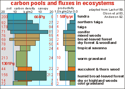
Carbon
pools and fluxes in terrestrial ecosystems Although
this diagram classifies soils and ecosystems slightly differently, it gives
a good and exact overview of the productivity (right-hand column) and stored
carbon in the soil (left) and above the soil (middle). The histograms are
in amount of carbon per square metre and the red numbers are totals for
each class, in Pg (billions of tonnes, Gt). The bold red numbers are world
totals for each columns. Notice that the heighth of each rectangle represents
the relative area covered by each type of ecosystem. It can be seen that
warm grassland covers most of the continents and highland woods least.
Example: warm grasslands cover
the largest area (vertical size), have a very low investment in canopy
but moderate carbon investment underground, and they are moderately productive.
Example: humid broad-leaved
forests have high productivity and a very high investment in carbon above
ground versus moderate investment underground.
Example: tundra have very
low investments above ground but very high amounts of carbon underground.
They are the least productive ecosystems of all.
It has been attempted to
align the ecosystems by latitude, although this was not strictly possible.
Going from tundra to warm grassland (top down), one sees productivity increasing,
then decreasing again. Likewise, the stored carbon above ground in roots
and foliage follows the same trend, but the amount of carbon underground
in roots and soil organisms decreases. Notice how grasslands have very
little organic matter above ground, but ten times more underground. Arid
soils have more biomass above than underground.
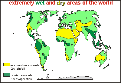
The map on right gives another
picture of the world's climate. It shows the problem areas where rainfall
either grossly exceeds evaporation (dark green) or the other way around
(yellow). In these areas, sustainable farming is extremely difficult, even
when enough drainage is applied in the wet zones or irrigation in the dry
zones. In the wet zones the nutrients and fertiliser are leached away easily
whereas in the dry zones salts accumulate in the soil. In the light green
areas, farming can be done sustainably but much of this area is still covered
in snow, ice and bare rock (not shown).
 Soil
formation depends on parent material, climate (temperature and moisture)
and biotic factors (mainly acidity, soil moisture content and drainage).
Since the minerals and elements that make up the parent material are well
mixed over the planet, the main groups of soil follow the main habitat
types of the world.
Soil
formation depends on parent material, climate (temperature and moisture)
and biotic factors (mainly acidity, soil moisture content and drainage).
Since the minerals and elements that make up the parent material are well
mixed over the planet, the main groups of soil follow the main habitat
types of the world.
 The
world's ecosystems depend primarily on their plants, which in turn depend
mainly on climate. Soil formation depends on the same climatic factors
as these, and on the acids produced by the plants. It is not surprising
then, that the main soil orders of the world follow the world's main ecosystems.
The diagram above shows the vegetation type (and ecosystem) as a function
of both temperature and rainfall. The boundaries between the various ecosystems
curve downward, going from left to right (hot to cold). This is because
more moisture is needed in warm climates, in order to offset their high
evaporation losses. So, an amount of 1m rainfall in the tropics is barely
enough for dry savanna grassland, but in the polar regions will lead to
the formation of bogs. Important is not the amount of rainfall but whether
it is more or less than natural evaporation. Below follow the soil characteristics,
going from cold to warm climate.
The
world's ecosystems depend primarily on their plants, which in turn depend
mainly on climate. Soil formation depends on the same climatic factors
as these, and on the acids produced by the plants. It is not surprising
then, that the main soil orders of the world follow the world's main ecosystems.
The diagram above shows the vegetation type (and ecosystem) as a function
of both temperature and rainfall. The boundaries between the various ecosystems
curve downward, going from left to right (hot to cold). This is because
more moisture is needed in warm climates, in order to offset their high
evaporation losses. So, an amount of 1m rainfall in the tropics is barely
enough for dry savanna grassland, but in the polar regions will lead to
the formation of bogs. Important is not the amount of rainfall but whether
it is more or less than natural evaporation. Below follow the soil characteristics,
going from cold to warm climate.
 Although
this diagram classifies soils and ecosystems slightly differently, it gives
a good and exact overview of the productivity (right-hand column) and stored
carbon in the soil (left) and above the soil (middle). The histograms are
in amount of carbon per square metre and the red numbers are totals for
each class, in Pg (billions of tonnes, Gt). The bold red numbers are world
totals for each columns. Notice that the heighth of each rectangle represents
the relative area covered by each type of ecosystem. It can be seen that
warm grassland covers most of the continents and highland woods least.
Although
this diagram classifies soils and ecosystems slightly differently, it gives
a good and exact overview of the productivity (right-hand column) and stored
carbon in the soil (left) and above the soil (middle). The histograms are
in amount of carbon per square metre and the red numbers are totals for
each class, in Pg (billions of tonnes, Gt). The bold red numbers are world
totals for each columns. Notice that the heighth of each rectangle represents
the relative area covered by each type of ecosystem. It can be seen that
warm grassland covers most of the continents and highland woods least.